
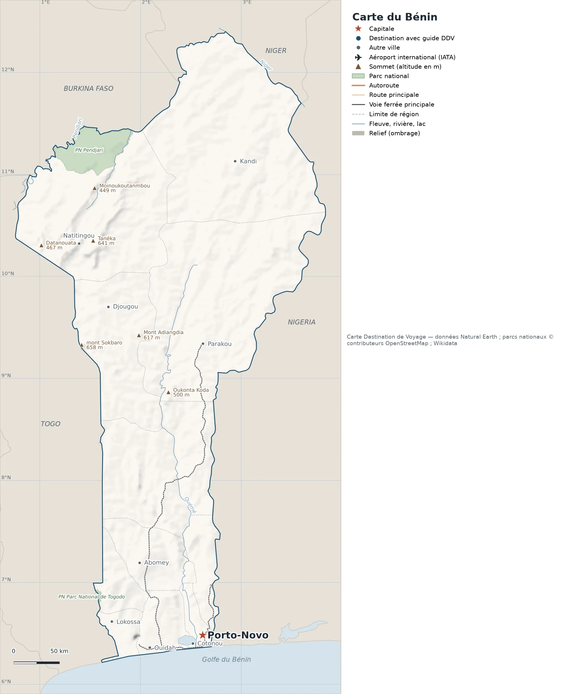
This map of Benin shows the capital (Porto-Novo) and the main cities, with terrain, national parks, railways and rivers.
Neighbouring countries (land border): Burkina Faso, Niger, Nigeria and Togo. Its coasts face: Gulf of Benin.

Our travel deals for Map
Affiliate links: we earn a commission, at no extra cost to you.
 FlightsKiwi.comCompare flights and airline combinations to Map.Compare flights
- eSIMAiraloData plan to install before you leave (eSIM-compatible phone).See plans


Open the full-size map (high resolution, zoomable)
Key: red star = capital; blue dot = destination covered by a Destination de Voyage guide; blue italic name = region or island with a guide; grey dot = other city; plane = international airport (IATA code); brown triangle = summit (elevation); green areas = national parks; thick orange line = expressway, light orange = main road; black-and-white line = main railway; grey dashes = regional boundaries; blue = rivers and lakes; shading = terrain; grid = latitude and longitude.
Sources: base map, cities, roads, railways, airports, administrative boundaries, rivers, lakes and hillshading: Natural Earth 1:10m (public domain). National parks: © OpenStreetMap contributors (ODbL licence). Summits and elevations: Wikidata and Natural Earth. Places missing from Natural Earth: Wikipedia coordinates. Map produced by Destination de Voyage.
Regions and destinations on the map of Benin
| Region | Our guides | Other cities on the map |
|---|---|---|
| Alibori | — | Kandi |
| Atacora | — | Natitingou |
| Atlantique | — | Ouidah |
| Borgou | — | Parakou |
| Donga | — | Djougou |
| Mono | — | Lokossa |
| Ouémé | — | Cotonou |
| Zou | — | Abomey |
Straight-line distances between the main cities
Straight-line distances calculated from the coordinates of the places (haversine formula). Actual journeys by road, rail, boat or plane are longer.
| Route | Straight-line distance |
|---|---|
| Porto-Novo – Parakou | 318 km (198 mi) |
| Porto-Novo – Djougou | 372 km (231 mi) |
| Porto-Novo – Kandi | 518 km (322 mi) |
| Porto-Novo – Ouidah | 60 km (37 mi) |
| Porto-Novo – Abomey | 105 km (65 mi) |
| Porto-Novo – Natitingou | 447 km (278 mi) |
| Porto-Novo – Lokossa | 101 km (63 mi) |
Terrain, national parks and airports
Main summits (elevations from Wikidata / Natural Earth): Mount Sokbaro (658 m / 2,159 ft), Tanéka (641 m / 2,103 ft), Mount Adiangdia (617 m / 2,024 ft), Mount Goubono (613 m / 2,011 ft) and Koudouogo (561 m / 1,841 ft).
National parks shown (2): Togodo National Park and Pendjari National Park.
Our guide
The 12 regions of Benin and what sets them apart
The Natural Earth base map divides Benin into 12 first-level subdivisions (type: Department). These are the grey dashed boundaries on the map. The table ranks them from largest to smallest, with the cities, the highest point and the international airports the map places in each.
| Region | Type | Area | Cities and guides | Highest point shown | Airport |
|---|---|---|---|---|---|
| Alibori | Department | 26,689 km² (10,305 sq mi) | Kandi | — | — |
| Borgou | Department | 25,624 km² (9,893 sq mi) | Parakou | Bonazuro (521 m / 1,709 ft) | — |
| Atacora | Department | 21,250 km² (8,205 sq mi) | Natitingou | Tanéka (641 m / 2,103 ft) | — |
| Collines | Department | 14,345 km² (5,539 sq mi) | — | Mount Koudia (366 m / 1,201 ft) | — |
| Donga | Department | 11,005 km² (4,249 sq mi) | Djougou | Mount Sokbaro (658 m / 2,159 ft) | — |
| Zou | Department | 5,087 km² (1,964 sq mi) | Abomey | — | — |
| Atlantique | Department | 3,138 km² (1,212 sq mi) | Ouidah | — | — |
| Plateau | Department | 3,079 km² (1,189 sq mi) | — | — | — |
| Couffo | Department | 2,741 km² (1,058 sq mi) | — | — | — |
| Mono | Department | 1,727 km² (667 sq mi) | Lokossa | — | — |
| Ouémé (capital) | Department | 1,372 km² (530 sq mi) | Cotonou, Porto-Novo | — | — |
| Littoral | Department | 58 km² (22 sq mi) | — | — | — |
- Largest: Alibori, about 26,689 km² (10,305 sq mi), or 23% of the mapped territory.
- Smallest: Littoral, about 58 km² (22 sq mi).
- Capital region: Porto-Novo is in the Ouémé subdivision.
- Highest region: Donga, home to Mount Sokbaro (658 m / 2,159 ft), the highest summit shown on the map.
How to read the map of Benin
- Extent: the mapped territory covers about 116,113 km² / 44,831 sq mi (Destination de Voyage calculation on the Natural Earth outline; Wikidata gives 114,763 km² / 44,310 sq mi). It spans from 6.21° N to 12.40° N in latitude and from 0.76° E to 3.84° E in longitude, about 688 km (428 mi) north to south and 338 km (210 mi) west to east (bounding box, outlying territories included).
- Outline: the perimeter of the territory on the map (coastline and land borders) measures about 1,996 km (1,240 mi). The simplified Natural Earth outline smooths out small detours, so the real length of the coastline is greater. Destination de Voyage calculation.
- Time zone (IANA tz database 2026b): Cotonou:
Africa/Porto-Novo(UTC+1, all year). Time difference and clock changes: Benin time difference. - Terrain: shading shows the relief and brown triangles mark the summits. The highest shown are Mount Sokbaro (658 m / 2,159 ft), Tanéka (641 m / 2,103 ft), Mount Adiangdia (617 m / 2,024 ft), Mount Goubono (613 m / 2,011 ft) and Dimansenntari (602 m / 1,975 ft). Wikidata gives Mount Sokbaro (658 m / 2,159 ft) as the highest point.
- Rivers (blue lines): Ouémé (about 511 km / 318 mi drawn within the territory), Pendjari (about 170 km / 106 mi drawn within the territory), Niger (about 109 km / 68 mi drawn within the territory). Lengths measured on the simplified Natural Earth outline: Destination de Voyage calculation.
- National parks (green areas): 1 whose centre lies within the territory: Pendjari National Park. Outlines from OpenStreetMap or position from Wikidata.
Distances between the main cities (cross table)
Straight-line distances between the capital, our destinations and the largest cities on the map, with the direction from the first city. Roads or ferries always add distance.
| Route | Straight-line distance | Direction |
|---|---|---|
| Porto-Novo → Cotonou | 14 km (9 mi) | southwest |
| Porto-Novo → Djougou | 372 km (231 mi) | north |
| Porto-Novo → Parakou | 318 km (198 mi) | north |
| Porto-Novo → Kandi | 518 km (322 mi) | north |
| Porto-Novo → Lokossa | 101 km (63 mi) | west |
| Porto-Novo → Ouidah | 60 km (37 mi) | west |
| Cotonou → Djougou | 378 km (235 mi) | north |
| Cotonou → Parakou | 327 km (203 mi) | north |
| Cotonou → Kandi | 528 km (328 mi) | north |
| Cotonou → Lokossa | 92 km (57 mi) | west |
| Cotonou → Ouidah | 48 km (30 mi) | west |
| Djougou → Parakou | 111 km (69 mi) | east |
| Djougou → Kandi | 210 km (130 mi) | northeast |
| Djougou → Lokossa | 343 km (213 mi) | south |
| Djougou → Ouidah | 374 km (232 mi) | south |
| Parakou → Kandi | 202 km (126 mi) | north |
| Parakou → Lokossa | 319 km (198 mi) | south |
| Parakou → Ouidah | 336 km (209 mi) | south |
Typical routes in Benin from the map
- Our complete guide to Benin: must-sees, detailed itineraries and budget
- When to go to Benin? Best time to visit and climate month by month
- Benin time difference: what time is it?
Frequently asked questions
What is the capital of Benin?
Porto-Novo, marked by the red star on the map.
Which countries border Benin?
Countries sharing a land border: Burkina Faso, Niger, Nigeria and Togo.
What is the highest summit shown on the map?
Mount Sokbaro, at an elevation of 658 m / 2,159 ft (source: Wikidata).
Where is Porto-Novo on the map of Benin?
At 6.48° N and 2.62° E, marked by the red star, in the Ouémé subdivision.
How many regions does Benin have?
Our map, based on Natural Earth, shows 12 first-level subdivisions (Department). Wikidata lists 12 entities of type “department of Benin” attached directly to the territory; the official division may differ from the one on the map.
Where is Benin?
Continent: Africa (Wikidata). Benin lies in the northern hemisphere, east of the Greenwich meridian. Coasts: Gulf of Benin. Land borders: Burkina Faso, Niger, Nigeria and Togo.
What is the area of Benin?
About 116,113 km² (44,831 sq mi) according to our calculation on the Natural Earth outline; Wikidata gives 114,763 km² (44,310 sq mi). The differences come from the precision of the coastline and inland waters.
Our sources
- Natural Earth 1:10m (public domain): country and subdivision boundaries, cities, airports, rivers, lakes, terrain, at naturalearthdata.com.
- Wikidata, item Q962 (Benin): area, highest point, continent and subdivisions, accessed 23 October 2026.
- © OpenStreetMap contributors (ODbL licence): national park outlines.
- Wikidata: position of national parks and elevation of summits.
- Wikipedia (French edition): coordinates of places missing from Natural Earth.
- Destination de Voyage calculations: distances (haversine, radius 6,371 km / 3,959 mi), bearings and areas (WGS84 ellipsoid, pyproj library).