
This map of Kazakhstan shows the capital, Astana, the 2 destinations covered in our guides and the main towns, with the terrain, national parks, expressways, railways, rivers and international airports.

Our travel deals for Map
Affiliate links: we earn a commission, at no extra cost to you.
 FlightsKiwi.comCompare flights and airline combinations to Map.Compare flights
- eSIMSailyAnother eSIM plan to compare: data, validity, network.See Saily plans


Safety (UK FCDO and U.S. Department of State, read on 12 November 2026): the UK FCDO (GOV.UK, updated 30 October 2026) does not advise against travel to any part of Kazakhstan, but lists areas that are closed to visitors unless you have prior permission from the Foreign Ministry, the Interior Ministry and the National Security Committee: Gvardeyskiy village in the Almaty region, the town of Baikonur, and the districts of Karmakchi and Kazalinsk in the Kyzylorda region. The U.S. Department of State rates Kazakhstan Level 1, Exercise Normal Precautions (travel advisory dated August 17, 2026), and says you must receive permission from the Kazakh government before travelling to certain areas bordering China and cities close to military installations. Sources: GOV.UK, Kazakhstan travel advice and travel.state.gov, Kazakhstan (page last updated August 13, 2026).
Places, summits and parks located in these areas remain drawn on the map for geographical reference, but we do not mention or recommend them.
Neighbouring countries (land border): China, Kyrgyzstan, Uzbekistan, Russia and Turkmenistan. Its coastline is on the Caspian Sea.
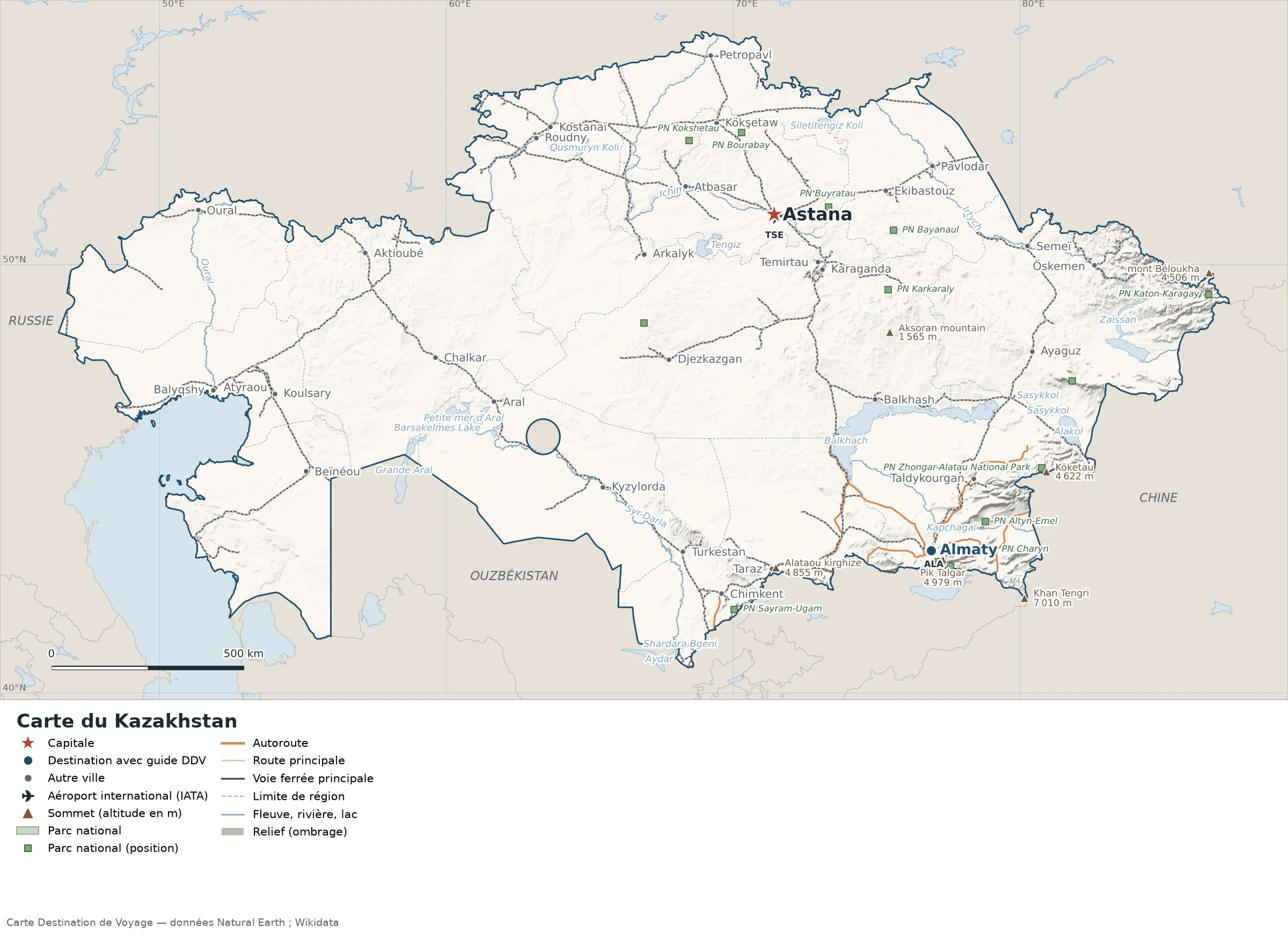
Open the full-size map (high resolution, zoomable)
Key: red star = capital; blue dot = destination covered by a Destination de Voyage guide; blue italic name = region or island with a guide; grey dot = other city; plane = international airport (IATA code); brown triangle = summit (elevation); green areas = national parks (green square = national park shown as a point); thick orange line = expressway, light orange = main road; black-and-white line = main railway; grey dashes = regional boundaries; blue = rivers and lakes; shading = terrain; grid = latitude and longitude.
Sources: base map, cities, roads, railways, airports, administrative boundaries, rivers, lakes and hillshading: Natural Earth 1:10m (public domain). National parks: Wikidata. Summits and elevations: Wikidata and Natural Earth. Places missing from Natural Earth: Wikipedia coordinates. Map produced by Destination de Voyage.
Regions and destinations on the map of Kazakhstan
| Region | Our guides | Other cities on the map |
|---|---|---|
| Almaty | Almaty | Taldykorgan, Sarkand, Kapchagay |
| Nur-Sultan (Astana) | Astana | — |
| Akmola | — | Kokshetau |
| Aktobe | — | Aktobe |
| Atyrau | — | Atyrau |
| Jambyl | — | Taraz |
| Karaganda | — | Karaganda |
| West Kazakhstan | — | Oral |
| East Kazakhstan | — | Öskemen |
| North Kazakhstan | — | Petropavl |
| Kostanay | — | Rudny |
| Kyzylorda | — | Kyzylorda |
| Turkistan Region | — | Shymkent |
| Pavlodar | — | Pavlodar |
Straight-line distances between the main cities
Straight-line distances calculated from the coordinates of the places (haversine formula). Actual journeys by road, rail, ferry or air are longer.
| Route | Straight-line distance |
|---|---|
| Astana – Almaty | 966 km (600 mi) |
| Astana – Karaganda | 187 km (116 mi) |
| Astana – Shymkent | 995 km (618 mi) |
| Astana – Taraz | 921 km (572 mi) |
| Astana – Pavlodar | 400 km (249 mi) |
| Astana – Öskemen | 800 km (497 mi) |
| Astana – Kyzylorda | 836 km (519 mi) |
| Astana – Aktobe | 1,007 km (626 mi) |
Terrain, national parks and airports
Main summits (elevations from Wikidata / Natural Earth): Khan Tengri (7,010 m / 22,999 ft), Talgar Peak (4,979 m / 16,335 ft), Kyrgyz Alatau (4,855 m / 15,928 ft), Semenov-Tyan-Shansky Peak (4,622 m / 15,164 ft), Köketau (4,622 m / 15,164 ft).
National parks shown (14): Tarbagatai National Park, Ulytau National Park, Zhongar-Alatau National Park, Altyn-Emel National Park, Sayram-Ugam National Park, Ile-Alatau National Park, Bayanaul National Park, Burabay National Park, Buiratau National Park, Charyn National Park, Karkaraly National Park, Katon-Karagay National Park, Kokshetau National Park, Kolsai Lakes National Park.
International airports shown: TSE (Astana), ALA (Almaty).
Our guides by destination
Frequently asked questions
What is the capital of Kazakhstan?
Astana, shown by the red star on the map.
What is the destination in our guides farthest from Astana?
Almaty, about 966 km (600 mi) in a straight line (Destination de Voyage calculation).
Which countries border Kazakhstan?
Countries sharing a land border: China, Kyrgyzstan, Uzbekistan, Russia and Turkmenistan.
What is the highest summit shown on the map?
Khan Tengri, at 7,010 m (22,999 ft) (source: Wikidata).
Which international airports are on the map?
TSE (Astana), ALA (Almaty).