
This map of Mongolia shows the capital, Ulaanbaatar, the main cities, with terrain, national parks, railways, rivers and international airports.
Bordering countries (land border): China and Russia.

Our travel deals for Map
Affiliate links: we earn a commission, at no extra cost to you.
 FlightsKiwi.comCompare flights and airline combinations to Map.Compare flights
- eSIMAiraloData plan to install before you leave (eSIM-compatible phone).See plans


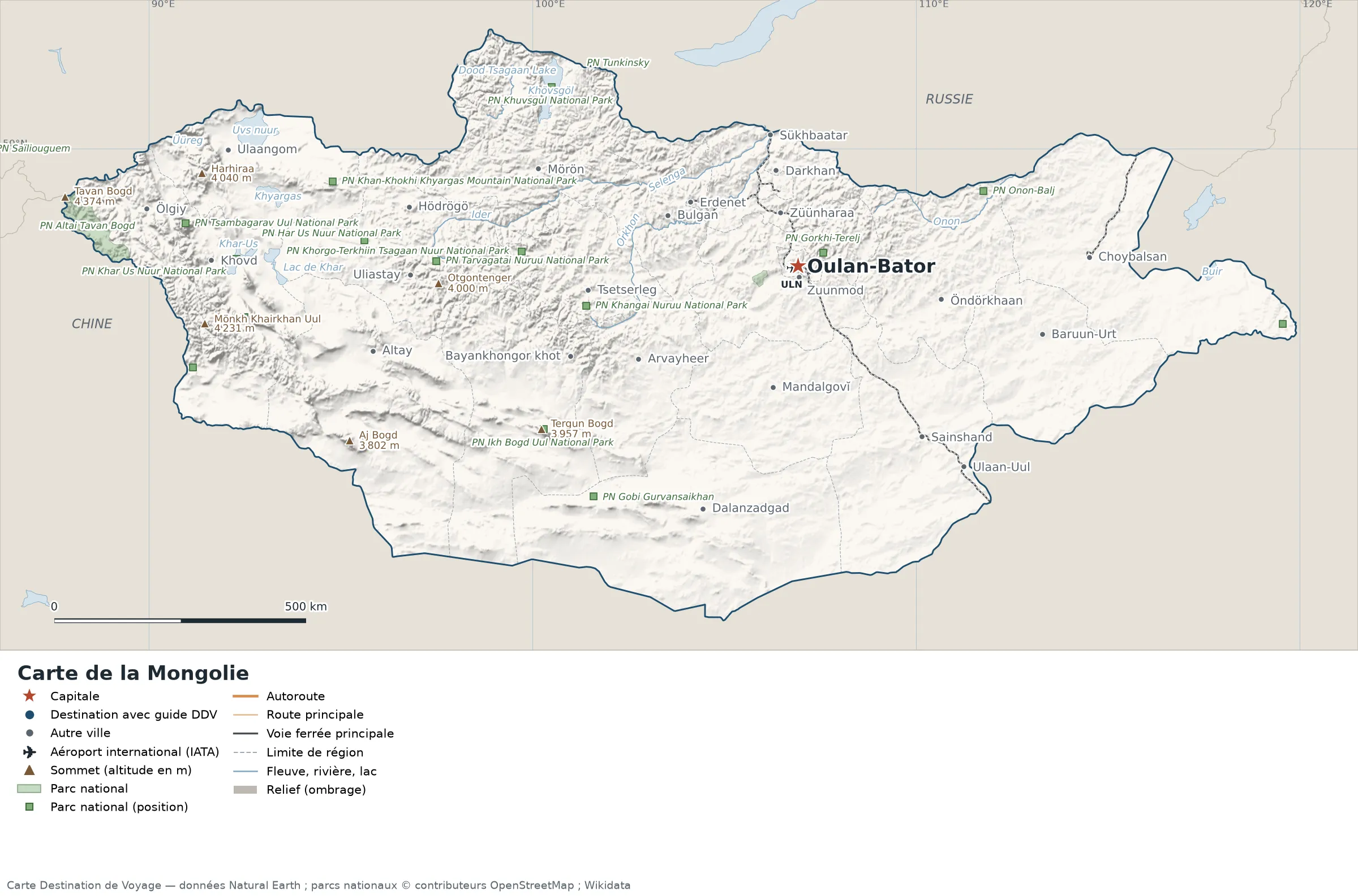
Open the full-size map (high resolution, zoomable)
Key: red star = capital; blue dot = destination covered by a Destination de Voyage guide; blue italic name = region or island with a guide; grey dot = other city; plane = international airport (IATA code); brown triangle = summit (elevation); green areas = national parks (green square = national park located by a point); thick orange line = expressway, light orange = main road; black-and-white line = main railway; grey dashes = regional boundaries; blue = rivers and lakes; shading = terrain; grid = latitude and longitude.
Sources: base map, cities, roads, railways, airports, administrative boundaries, rivers, lakes and hillshading: Natural Earth 1:10m (public domain). National parks: © OpenStreetMap contributors (ODbL licence) and Wikidata. Summits and elevations: Wikidata and Natural Earth. Places missing from Natural Earth: Wikipedia coordinates. Map produced by Destination de Voyage.
Regions and destinations on the map of Mongolia
| Region | Our guides | Other cities on the map |
|---|---|---|
| Bayankhongor | — | Bayankhongor khot |
| Bulgan | — | Bulgan |
| Dornod | — | Choybalsan |
| Govi-Altai | — | Altay |
| Khentii | — | Öndörkhaan |
| Khovd | — | Khovd |
| Khövsgöl | — | Mörön |
| Orkhon | — | Erdenet |
| Ulaanbaatar | — | Ulaanbaatar |
| Selenge | — | Darkhan |
| Sühbaatar | — | Baruun-Urt |
| Uvs | — | Ulaangom |
| Ömnögovi | — | Dalanzadgad |
| Övörkhangai | — | Arvayheer |
Straight-line distances between the main cities
Straight-line distances calculated from the coordinates of each place (haversine formula). Actual journeys by road, rail, ferry or plane are longer.
| Route | Straight-line distance |
|---|---|
| Ulaanbaatar – Erdenet | 242 km (150 mi) |
| Ulaanbaatar – Choybalsan | 565 km (351 mi) |
| Ulaanbaatar – Khovd | 1,136 km (706 mi) |
| Ulaanbaatar – Dalanzadgad | 519 km (322 mi) |
| Ulaanbaatar – Darkhan | 193 km (120 mi) |
| Ulaanbaatar – Ulaangom | 1,106 km (687 mi) |
| Ulaanbaatar – Altay | 853 km (530 mi) |
| Ulaanbaatar – Arvayheer | 365 km (227 mi) |
Terrain, national parks and airports
Main summits (elevations from Wikidata / Natural Earth): Tavan Bogd (4,374 m / 14,350 ft), Mönkh Khairkhan Uul (4,231 m / 13,881 ft), Sutai Mountain (4,220 m / 13,845 ft), Tsambagarav (4,193 m / 13,757 ft), Harhiraa (4,040 m / 13,255 ft).
National parks shown (20): Altai Tavan Bogd National Park, Bulgan Gol-Ikh Ongog National Park, Har Us Nuur National Park, Hustai National Park, Ikh Bogd Uul National Park, Khan-Khokhi Khyargas Mountain National Park, Khangai Nuruu National Park, Khar Us Nuur National Park, Khorgo-Terkhiin Tsagaan Nuur National Park, Khuvsgul National Park, Munkhkhairkhan National Park, Numrug National Park, Saylyugem National Park, Tarvagatai Nuruu National Park, Tsambagarav Uul National Park, Tunkinsky National Park, Ulaagchinii Khar Nuur National Park, Gorkhi-Terelj National Park, Onon-Balj National Park, Gobi Gurvansaikhan National Park.
International airports shown: ULN (Chinggis Khaan).
Our guide
Frequently asked questions
What is the capital of Mongolia?
Ulaanbaatar, marked by the red star on the map.
Which countries border Mongolia?
Countries sharing a land border: China and Russia.
What is the highest summit shown on the map?
Tavan Bogd, at an elevation of 4,374 m (14,350 ft), according to Natural Earth.
Which international airports are on the map?
ULN (Chinggis Khaan).