
This map of Taiwan shows the capital, Taipei, and the main cities, with terrain, national parks, expressways, railways and international airports.
Taiwan has no land border with another country on our base map. Its coasts face: Luzon Strait, Taiwan Strait, South China Sea, East China Sea and Philippine Sea.

Our travel deals for Map
Affiliate links: we earn a commission, at no extra cost to you.
 FlightsKiwi.comCompare flights and airline combinations to Map.Compare flights
- eSIMAiraloData plan to install before you leave (eSIM-compatible phone).See plans



Open the full-size map (high resolution, zoomable)
Key: red star = capital; blue dot = destination covered by a Destination de Voyage guide; blue italic name = region or island with a guide; grey dot = other city; plane = international airport (IATA code); brown triangle = summit (elevation); green areas = national parks; thick orange line = expressway, light orange = main road; black-and-white line = main railway; grey dashes = regional boundaries; blue = rivers and lakes; shading = terrain; grid = latitude and longitude.
Sources: base map, cities, roads, railways, airports, administrative boundaries, rivers, lakes and terrain hillshading: Natural Earth 1:10m (public domain). National parks: © OpenStreetMap contributors (ODbL licence). Summits and elevations: Wikidata and Natural Earth. Places missing from Natural Earth: Wikipedia coordinates. Map produced by Destination de Voyage.
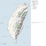
Regions and destinations on the map of Taiwan
| Region | Our guides | Other cities on the map |
|---|---|---|
| Changhua | — | Changhua |
| Chiayi | — | Chiayi |
| Chilung | — | Chilung |
| Hsinchu | — | Hsinchu |
| Hualien | — | Hualien |
| Kaohsiung | — | Kaohsiung |
| New Taipei | — | New Taipei |
| Penghu | — | Magong |
| Pingtung | — | Pingtung |
| Taichung | — | Taichung |
| Tainan | — | Tainan |
| Taipei | — | Taipei |
| Taitung | — | Taitung |
| Taoyuan | — | Zhongli |
Straight-line distances between the main cities
Straight-line distances calculated from the coordinates of the places (haversine formula). Actual journeys by road, rail, boat or plane are longer.
| Route | Straight-line distance |
|---|---|
| Taipei – Kaohsiung | 298 km (185 mi) |
| Taipei – Taichung | 133 km (83 mi) |
| Taipei – Magong | 259 km (161 mi) |
| Taipei – Tainan | 266 km (165 mi) |
| Taipei – Hsinchu | 64 km (40 mi) |
| Taipei – Hualien | 117 km (73 mi) |
| Taipei – Taitung | 257 km (160 mi) |
| Taipei – Zhongli | 36 km (22 mi) |
Terrain, national parks and airports
Main summits (elevations from Wikidata / Natural Earth): Yu Shan (3,952 m / 12,966 ft), Xueshan (3,886 m / 12,749 ft), Zhuoshe Mountain (3,368 m / 11,050 ft).
National parks shown (7): Kinmen National Park, Kenting National Park, Shei-Pa National Park, Taijiang National Park, Taroko National Park, Yangmingshan National Park, Yushan National Park.
International airports shown: KHH (Kaohsiung), TPE (Taoyuan).
Our guide
The 21 regions of Taiwan and what sets them apart
The Natural Earth base map divides Taiwan into 21 first-level subdivisions (type: Hsien, Shi and Zhixiashi). These are the grey dashed boundaries on the map. The table ranks them from largest to smallest, with the cities, the highest point and the international airports the map places in each.
| Region | Type | Area | Cities and guides | Highest point shown | Airport |
|---|---|---|---|---|---|
| Hualien | Hsien | 4,502 km² (1,738 sq mi) | Hualien | Mount Xiuguluan (3,825 m / 12,549 ft) | — |
| Nantou | Hsien | 4,154 km² (1,604 sq mi) | Nantou | Yu Shan (3,952 m / 12,966 ft) | — |
| Taitung | Hsien | 3,388 km² (1,308 sq mi) | Taitung | Guan Mountain (3,666 m / 12,028 ft) | — |
| Kaohsiung | Zhixiashi | 3,022 km² (1,167 sq mi) | Kaohsiung | Yu Shan (3,952 m / 12,966 ft) | KHH |
| Pingtung | Hsien | 2,846 km² (1,099 sq mi) | Pingtung | — | — |
| Taichung | Zhixiashi | 2,224 km² (859 sq mi) | Taichung | Xueshan (3,886 m / 12,749 ft) | — |
| Tainan | Zhixiashi | 2,202 km² (850 sq mi) | Tainan | — | — |
| Yilan | Hsien | 2,075 km² (801 sq mi) | Yilan | Nanhu East Peak (3,742 m / 12,277 ft) | — |
| Chiayi | Hsien | 1,977 km² (763 sq mi) | Puzi, Taibao | Yu Shan (3,952 m / 12,966 ft) | — |
| New Taipei | Zhixiashi | 1,937 km² (748 sq mi) | New Taipei | — | — |
| Miaoli | Hsien | 1,865 km² (720 sq mi) | Miaoli | Daxue Mountain (3,530 m / 11,581 ft) | — |
| Hsinchu | Hsien | 1,381 km² (533 sq mi) | Zhubei | Pintian Mountain (3,524 m / 11,562 ft) | — |
| Taoyuan | Hsien | 1,280 km² (494 sq mi) | Zhongli, Taoyuan, Pingzhen, Yangmei | — | TPE |
| Yunlin | Hsien | 1,273 km² (492 sq mi) | Touliu | — | — |
| Changhua | Hsien | 1,190 km² (459 sq mi) | Changhua | — | — |
| Taipei (capital) | Zhixiashi | 288 km² (111 sq mi) | Taipei | — | — |
| Jinmen | Hsien | 154 km² (59 sq mi) | — | — | — |
| Hsinchu | Shi | 154 km² (59 sq mi) | Hsinchu | — | — |
| Chilung | Shi | 108 km² (42 sq mi) | Chilung | — | — |
| Penghu | Hsien | 103 km² (40 sq mi) | Magong | — | — |
| Chiayi | Shi | 77 km² (30 sq mi) | Chiayi | — | — |
- Largest: Hualien, about 4,502 km² (1,738 sq mi), 12% of the mapped territory.
- Smallest: Chiayi, about 77 km² (30 sq mi).
- Capital region: Taipei is in the Taipei subdivision.
- Highest region: Nantou, home to Yu Shan (3,952 m / 12,966 ft), the highest summit shown on the map.
- Air access: the international airports on the map are spread across 2 of 21 regions (Kaohsiung and Taoyuan).
How to read the map of Taiwan
- Extent: the mapped territory covers about 36,198 km² (13,976 sq mi), by Destination de Voyage calculation on the Natural Earth outline; Wikidata gives 36,193 km² (13,974 sq mi). It extends from 21.90° N to 25.29° N in latitude and from 118.28° E to 122.01° E in longitude, about 376 km (234 mi) from north to south and 380 km (236 mi) from west to east (bounding rectangle, outlying territories included).
- Outline: the perimeter of the territory on the map (coasts and land borders) is about 1,270 km (789 mi). The simplified Natural Earth outline smooths out small detours, so the real length of the coastline is greater. Destination de Voyage calculation.
- Time zone (IANA tz database 2026b): Taipei:
Asia/Taipei(UTC+8, all year). Difference from London and New York, and clock changes: Taiwan time difference. - Terrain: shading shows the relief and brown triangles mark the summits. The highest shown are Yu Shan (3,952 m / 12,966 ft), Xueshan (3,886 m / 12,749 ft), Linzhi Shan (3,854 m / 12,644 ft), Mount Xiuguluan (3,825 m / 12,549 ft), Mabolasi Mountain (3,785 m / 12,418 ft). Wikidata gives Yu Shan (3,952 m / 12,966 ft) as the highest point.
- National parks (green areas): 6 with their centre inside the territory, including Kinmen National Park, Kenting National Park, Shei-Pa National Park, Taroko National Park, Yangmingshan National Park and Yushan National Park. Outlines from OpenStreetMap or position from Wikidata.
- International airports (plane icon): KHH (Kaohsiung, about 11 km (7 mi) from the centre of Kaohsiung); TPE (Taoyuan, about 13 km (8 mi) from the centre of Zhongli). Straight-line distances: Destination de Voyage calculation.
Distances between the main cities (cross table)
Straight-line distances between the capital, our destinations and the largest cities on the map, with the direction from the first city. Roads or ferries always add distance.
| Route | Straight-line distance | Direction |
|---|---|---|
| Taipei → New Taipei | 11 km (7 mi) | west |
| Taipei → Kaohsiung | 298 km (185 mi) | southwest |
| Taipei → Taichung | 133 km (83 mi) | southwest |
| Taipei → Tainan | 266 km (165 mi) | southwest |
| Taipei → Zhongli | 36 km (22 mi) | west |
| Taipei → Hsinchu | 64 km (40 mi) | west |
| New Taipei → Kaohsiung | 291 km (181 mi) | southwest |
| New Taipei → Taichung | 124 km (77 mi) | southwest |
| New Taipei → Tainan | 258 km (160 mi) | southwest |
| New Taipei → Zhongli | 26 km (16 mi) | west |
| New Taipei → Hsinchu | 54 km (34 mi) | southwest |
| Kaohsiung → Taichung | 174 km (108 mi) | north |
| Kaohsiung → Tainan | 41 km (25 mi) | north |
| Kaohsiung → Zhongli | 277 km (172 mi) | north |
| Kaohsiung → Hsinchu | 253 km (157 mi) | north |
| Taichung → Tainan | 137 km (85 mi) | south |
| Taichung → Zhongli | 105 km (65 mi) | northeast |
| Taichung → Hsinchu | 80 km (50 mi) | north |
Sample itineraries for Taiwan based on the map
- Our complete guide to Taiwan: highlights, detailed itineraries and budget
- When to go to Taiwan: best time and month-by-month climate
- Time difference: Taiwan
Frequently asked questions
What is the capital of Taiwan?
Taipei, marked by the red star on the map.
What is the highest summit shown on the map?
Yu Shan, at an elevation of 3,952 m (12,966 ft) (source: Natural Earth).
Which international airports are on the map?
KHH (Kaohsiung), TPE (Taoyuan).
Where is Taipei on the map of Taiwan?
At 25.04° N, 121.57° E, marked by the red star, in the Taipei subdivision.
How many regions does Taiwan have?
Our map, based on Natural Earth, shows 21 first-level subdivisions (Hsien, Shi and Zhixiashi). Wikidata lists 6 entities of type « special municipality » attached directly to the territory; the official division may differ from the one on our map.
Where is Taiwan?
Continent: Asia (Wikidata). Taiwan lies in the Northern Hemisphere, east of the Greenwich meridian (Taipei taken as the reference point; Destination de Voyage calculation). Coasts: Luzon Strait, Taiwan Strait, South China Sea, East China Sea and Philippine Sea.
What is the area of Taiwan?
About 36,198 km² (13,976 sq mi) by our calculation on the Natural Earth outline; Wikidata gives 36,193 km² (13,974 sq mi). The differences come from the precision of the coastline and inland waters.
Our sources
- Natural Earth 1:10m (public domain): country and subdivision boundaries, cities, airports, rivers, lakes, terrain, at naturalearthdata.com.
- Wikidata, item Q865 (Taiwan): area, highest point, continent and subdivisions, accessed 23 October 2026.
- © OpenStreetMap contributors (ODbL licence): national park outlines.
- Wikidata: position of national parks and elevation of summits.
- Wikipedia (French edition): coordinates of places missing from Natural Earth.
- Destination de Voyage calculations: distances (haversine, 6,371 km radius), directions and areas (WGS84 ellipsoid, pyproj library).
- Our methodology