
This map of Cuba shows the capital, Havana, and the main cities, with terrain, national parks, expressways, railways and international airports.

Our travel deals for Map
Affiliate links: we earn a commission, at no extra cost to you.
 FlightsKiwi.comCompare flights and airline combinations to Map.Compare flights
- eSIMSailyAnother eSIM plan to compare: data, validity, network.See Saily plans


⚠️ Warning: travel to Cuba
The UK Foreign, Commonwealth & Development Office (FCDO) advises against all but essential travel to Cuba, citing power cuts, fuel shortages that disrupt transport and other services, and flight suspensions by several airlines (GOV.UK, updated 25 September 2026, checked 11 November 2026): read the FCDO travel advice for Cuba before making any plans.
Neighbouring countries (land border): Guantánamo Bay naval base. Its coasts face: Yucatán Channel, Straits of Florida, Gulf of Mexico, Caribbean Sea and Atlantic Ocean.
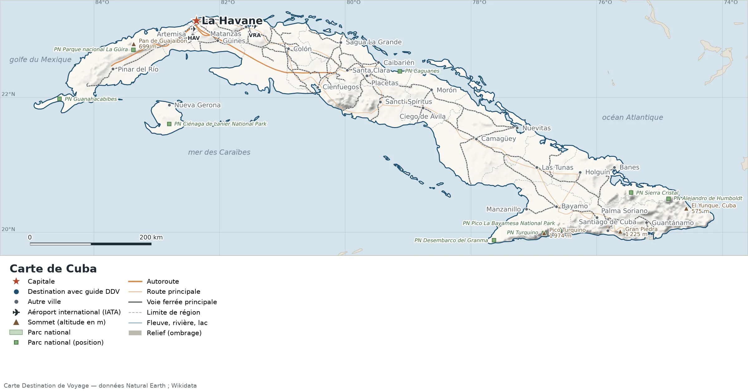
Open the full-size map (high resolution, zoomable)
Key: red star = capital; blue dot = destination covered by a Destination de Voyage guide; blue italic name = region or island with a guide; grey dot = other city; plane = international airport (IATA code); brown triangle = summit (elevation); green areas = national parks (green square = national park located by a point); thick orange line = expressway, light orange = main road; black-and-white line = main railway; grey dashes = regional boundaries; blue = rivers and lakes; shading = terrain; grid = latitude and longitude.
Sources: base map, cities, roads, railways, airports, administrative boundaries, rivers, lakes and terrain hillshading: Natural Earth 1:10m (public domain). National parks: Wikidata. Summits and elevations: Wikidata and Natural Earth. Places missing from Natural Earth: Wikipedia coordinates. Map produced by Destination de Voyage.
Regions and destinations on the map of Cuba
| Region | Our guides | Other cities on the map |
|---|---|---|
| Artemisa | — | Artemisa |
| Camagüey | — | Camagüey |
| Ciego de Ávila | — | Morón |
| Cienfuegos | — | Cienfuegos |
| Granma | — | Bayamo |
| Guantánamo | — | Guantánamo |
| Holguín | — | Holguín |
| Havana | — | Havana |
| Las Tunas | — | Las Tunas |
| Matanzas | — | Matanzas |
| Pinar del Río | — | Pinar del Río |
| Sancti Spíritus | — | Sancti Spíritus |
| Santiago de Cuba | — | Santiago de Cuba |
| Villa Clara | — | Santa Clara |
Straight-line distances between the main cities
Straight-line distances calculated from the coordinates of the places (haversine formula). Actual journeys by road, rail, boat or plane are longer.
| Route | Straight-line distance |
|---|---|
| Havana – Santiago de Cuba | 760 km (472 mi) |
| Havana – Camagüey | 498 km (309 mi) |
| Havana – Holguín | 677 km (421 mi) |
| Havana – Guantánamo | 811 km (504 mi) |
| Havana – Santa Clara | 259 km (161 mi) |
| Havana – Pinar del Río | 158 km (98 mi) |
| Havana – Las Tunas | 608 km (378 mi) |
| Havana – Bayamo | 666 km (414 mi) |
Terrain, national parks and airports
Main summits (elevations from Wikidata / Natural Earth): Pico Turquino (1,974 m / 6,476 ft), Gran Piedra (1,225 m / 4,019 ft), Pan de Guajaibón (699 m / 2,293 ft), El Yunque, Cuba (575 m / 1,886 ft), sierra La Guasasa (379 m / 1,243 ft).
National parks shown (9): Ciénaga de Lanier National Park, Parque nacional La Güira, Pico La Bayamesa National Park, Alejandro de Humboldt National Park, Caguanes National Park, Desembarco del Granma National Park, Sierra Cristal National Park, Turquino National Park, Guanahacabibes National Park.
International airports shown: VRA (Juan Gualberto Gomez), HAV (José Martí).
Our guide
Frequently asked questions
What is the capital of Cuba?
Havana, marked by the red star on the map.
Which countries border Cuba?
Countries sharing a land border: Guantánamo Bay naval base.
What is the highest summit shown on the map?
Pico Turquino, at an elevation of 1,974 m (6,476 ft) (source: Natural Earth).
Which international airports are on the map?
VRA (Juan Gualberto Gomez), HAV (José Martí).
Our sources
- Natural Earth 1:10m (public domain): country and subdivision boundaries, cities, airports, rivers, lakes, terrain, at naturalearthdata.com.
- Wikidata and Wikipedia (French edition): positions, elevations and coordinates.
- Destination de Voyage calculations: distances (haversine, 6,371 km radius).
- UK Foreign, Commonwealth & Development Office, Foreign travel advice: Cuba (GOV.UK, updated 25 September 2026, checked 11 November 2026).
- Our methodology