
This map of Botswana shows the capital (Gaborone) and the main cities, with terrain, national parks, railways, rivers and international airports.
Neighbouring countries (land border): South Africa, Namibia, Zambia and Zimbabwe.

Our travel deals for Map
Affiliate links: we earn a commission, at no extra cost to you.
 FlightsKiwi.comCompare flights and airline combinations to Map.Compare flights
- eSIMAiraloData plan to install before you leave (eSIM-compatible phone).See plans


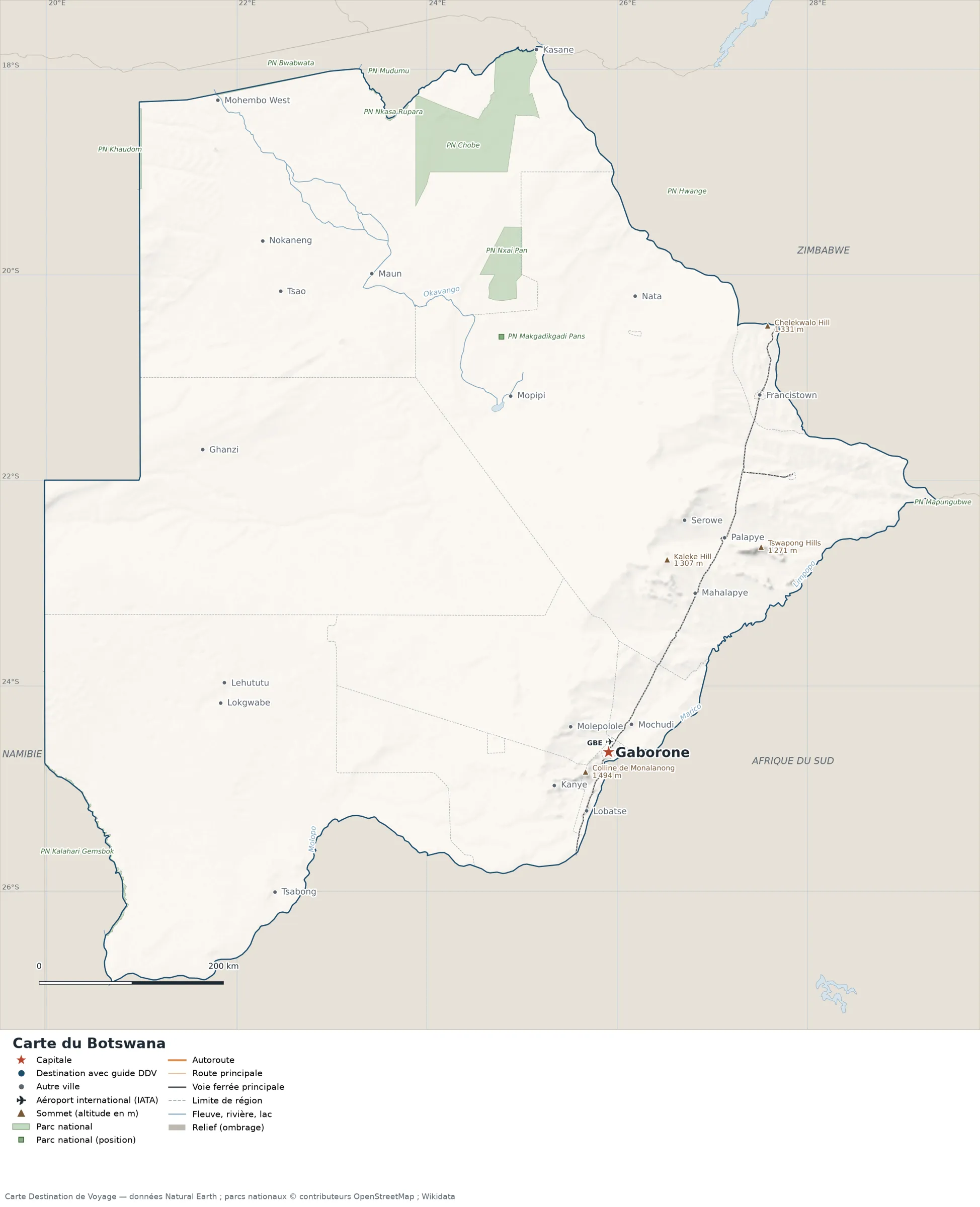
Open the full-size map (high resolution, zoomable)
Key: red star = capital; blue dot = destination covered by a Destination de Voyage guide; blue italic name = region or island with a guide; grey dot = other city; plane = international airport (IATA code); brown triangle = summit (elevation); green areas = national parks (green square = national park shown as a point); thick orange line = expressway, light orange = main road; black-and-white line = main railway; grey dashes = regional boundaries; blue = rivers and lakes; shading = terrain; grid = latitude and longitude.
Sources: base map, cities, roads, railways, airports, administrative boundaries, rivers, lakes and hillshading: Natural Earth 1:10m (public domain). National parks: © OpenStreetMap contributors (ODbL licence) and Wikidata. Summits and elevations: Wikidata and Natural Earth. Places missing from Natural Earth: Wikipedia coordinates. Map produced by Destination de Voyage.
Regions and destinations on the map of Botswana
| Region | Our guides | Other cities on the map |
|---|---|---|
| Central | — | Mahalapye |
| Francistown | — | Francistown |
| Gaborone | — | Gaborone |
| Ghanzi | — | Ghanzi |
| Kgalagadi | — | Tsabong |
| Kgatleng | — | Mochudi |
| Kweneng | — | Molepolole |
| Lobatse | — | Lobatse |
| North-West | — | Maun |
| Southern | — | Kanye |
Straight-line distances between the main cities
Straight-line distances calculated from the coordinates of the places (haversine formula). Actual journeys by road, rail, boat or plane are longer.
| Route | Straight-line distance |
|---|---|
| Gaborone – Francistown | 419 km (260 mi) |
| Gaborone – Mahalapye | 195 km (121 mi) |
| Gaborone – Serowe | 264 km (164 mi) |
| Gaborone – Molepolole | 49 km (30 mi) |
| Gaborone – Lobatse | 68 km (42 mi) |
| Gaborone – Maun | 578 km (359 mi) |
| Gaborone – Kanye | 68 km (42 mi) |
| Gaborone – Palapye | 263 km (163 mi) |
Terrain, national parks and airports
Main summits (elevations from Wikidata / Natural Earth): Monalanong Hill (1,494 m / 4,902 ft), Ditshilo Hills (1,438 m / 4,718 ft), Chelekwalo Hill (1,331 m / 4,367 ft), Mmakanke (1,312 m / 4,304 ft) and Kaleke Hill (1,307 m / 4,288 ft).
National parks shown (10): Chobe National Park, Kalahari Gemsbok National Park, Mapungubwe National Park, Mudumu National Park, Nkasa Rupara National Park, Nxai Pan National Park, Hwange National Park, Bwabwata National Park, Khaudom National Park and Makgadikgadi Pans National Park.
International airports shown: GBE (Sir Seretse Khama).
Our guide
The 15 regions of Botswana and what sets them apart
The Natural Earth base map divides Botswana into 15 first-level subdivisions (type: City, District, Town and Township). These are the grey dashed boundaries on the map. The table ranks them from largest to smallest, with the cities, the highest point and the international airports the map places in each.
| Region | Type | Area | Cities and guides | Highest point shown | Airport |
|---|---|---|---|---|---|
| Central | District | 146,220 km² (56,456 sq mi) | Mahalapye, Serowe, Palapye, Nata | Kaleke Hill (1,307 m / 4,288 ft) | — |
| North-West | District | 133,313 km² (51,472 sq mi) | Maun, Kasane, Nokaneng, Tsao | — | — |
| Ghanzi | District | 114,834 km² (44,338 sq mi) | Ghanzi | — | — |
| Kgalagadi | District | 105,425 km² (40,705 sq mi) | Tsabong, Lehututu, Lokgwabe | — | — |
| Kweneng | District | 36,908 km² (14,250 sq mi) | Molepolole | Mmakanke (1,312 m / 4,304 ft) | — |
| Southern | District | 26,982 km² (10,418 sq mi) | Kanye | Monalanong Hill (1,494 m / 4,902 ft) | — |
| Kgatleng | District | 7,686 km² (2,968 sq mi) | Mochudi | — | — |
| North-East | District | 5,221 km² (2,016 sq mi) | — | Chelekwalo Hill (1,331 m / 4,367 ft) | — |
| South-East | District | 1,617 km² (624 sq mi) | Lobatse | Monalanong Hill (1,494 m / 4,902 ft) | — |
| Jwaneng | Town | 339 km² (131 sq mi) | — | — | — |
| Gaborone (capital) | City | 285 km² (110 sq mi) | Gaborone | Mount Kgale (1,287 m / 4,222 ft) | GBE |
| Francistown | City | 90 km² (35 sq mi) | Francistown | — | — |
| Sowa Town | Township | 55 km² (21 sq mi) | — | — | — |
| Selebi-Phikwe | Town | 35 km² (14 sq mi) | — | — | — |
| Lobatse | Town | 20 km² (8 sq mi) | Lobatse | — | — |
- Largest: Central, about 146,220 km² (56,456 sq mi), or 25% of the mapped territory.
- Smallest: Lobatse, about 20 km² (8 sq mi).
- Capital region: Gaborone is in the Gaborone subdivision.
- Highest region: Southern, home to Monalanong Hill (1,494 m / 4,902 ft), the highest summit shown on the map.
- Air access: the international airports on the map are spread across 1 of the 15 regions (Gaborone).
How to read the map of Botswana
- Extent: the mapped territory covers about 579,029 km² / 223,564 sq mi (Destination de Voyage calculation on the Natural Earth outline; Wikidata gives 581,737 km² / 224,610 sq mi). It spans from 26.89° S to 17.78° S in latitude and from 19.98° E to 29.35° E in longitude, about 1,013 km (629 mi) north to south and 964 km (599 mi) west to east (bounding box, outlying territories included).
- Outline: the perimeter of the territory on the map (land borders) measures about 3,751 km (2,331 mi). The simplified Natural Earth outline smooths out small detours, so the real length of the borders is greater. Destination de Voyage calculation.
- Time zone (IANA tz database 2026b): Gaborone:
Africa/Gaborone(UTC+2, all year). - Terrain: shading shows the relief and brown triangles mark the summits. The highest shown are Monalanong Hill (1,494 m / 4,902 ft), Otse Hill (1,491 m / 4,892 ft), Ditshilo Hills (1,438 m / 4,718 ft), Lohawe Hills (1,403 m / 4,603 ft) and Dinaka Hills (1,389 m / 4,557 ft). Wikidata gives Otse Hill (1,491 m / 4,892 ft) as the highest point.
- Rivers (blue lines): Okavango (about 805 km / 500 mi drawn within the territory), Molopo (about 463 km / 288 mi drawn within the territory), Limpopo (about 347 km / 216 mi drawn within the territory), Notwani (about 206 km / 128 mi drawn within the territory), Marico (about 123 km / 76 mi drawn within the territory), Kwando (about 101 km / 63 mi drawn within the territory). Lengths measured on the simplified Natural Earth outline: Destination de Voyage calculation.
- Lakes named in Natural Earth: Lake Xau.
- National parks (green areas): 3 whose centre lies within the territory, including Chobe National Park, Nxai Pan National Park and Makgadikgadi Pans National Park. Outlines from OpenStreetMap or position from Wikidata.
- International airports (plane icon): GBE (Sir Seretse Khama, about 9.9 km / 6 mi from the centre of Gaborone). Straight-line distances: Destination de Voyage calculation.
Distances between the main cities (cross table)
Straight-line distances between the capital, our destinations and the largest cities on the map, with the direction from the first city. Roads or ferries always add distance.
| Route | Straight-line distance | Direction |
|---|---|---|
| Gaborone → Francistown | 419 km (260 mi) | northeast |
| Gaborone → Lobatse | 68 km (42 mi) | south |
| Gaborone → Molepolole | 49 km (30 mi) | northwest |
| Gaborone → Mahalapye | 195 km (121 mi) | northeast |
| Gaborone → Maun | 578 km (359 mi) | northwest |
| Gaborone → Serowe | 264 km (164 mi) | north |
| Francistown → Lobatse | 487 km (303 mi) | south |
| Francistown → Molepolole | 413 km (257 mi) | southwest |
| Francistown → Mahalapye | 226 km (140 mi) | south |
| Francistown → Maun | 445 km (277 mi) | west |
| Francistown → Serowe | 158 km (98 mi) | southwest |
| Lobatse → Molepolole | 93 km (58 mi) | north |
| Lobatse → Mahalapye | 263 km (163 mi) | northeast |
| Lobatse → Maun | 626 km (389 mi) | north |
| Lobatse → Serowe | 332 km (206 mi) | north |
| Molepolole → Mahalapye | 197 km (122 mi) | northeast |
| Molepolole → Maun | 536 km (333 mi) | northwest |
| Molepolole → Serowe | 255 km (158 mi) | northeast |
Typical routes in Botswana from the map
- Our complete guide to Botswana: must-sees, detailed itineraries and budget
- When to go to Botswana? Best time to visit and climate month by month
- For a trip combined with a neighbouring country: map of South Africa and map of Namibia.
Frequently asked questions
What is the capital of Botswana?
Gaborone, marked by the red star on the map.
Which countries border Botswana?
Countries sharing a land border: South Africa, Namibia, Zambia and Zimbabwe.
What is the highest summit shown on the map?
Monalanong Hill, at an elevation of 1,494 m / 4,902 ft (source: Natural Earth).
Which international airports are shown on the map?
GBE (Sir Seretse Khama).
Where is Gaborone on the map of Botswana?
At 24.65° S and 25.91° E, marked by the red star, in the Gaborone subdivision.
How many regions does Botswana have?
Our map, based on Natural Earth, shows 15 first-level subdivisions (City, District, Town and Township). Wikidata lists 9 entities of type “district of Botswana” attached directly to the territory; the official division may differ from the one on the map.
Where is Botswana?
Continent: Africa (Wikidata). Botswana lies in the southern hemisphere, east of the Greenwich meridian. Land borders: South Africa, Namibia, Zambia and Zimbabwe.
What is the area of Botswana?
About 579,029 km² (223,564 sq mi) according to our calculation on the Natural Earth outline; Wikidata gives 581,737 km² (224,610 sq mi). The differences come from the precision of the coastline and inland waters.
Our sources
- Natural Earth 1:10m (public domain): country and subdivision boundaries, cities, airports, rivers, lakes, terrain, at naturalearthdata.com.
- Wikidata, item Q963 (Botswana): area, highest point, continent and subdivisions, accessed 23 October 2026.
- © OpenStreetMap contributors (ODbL licence): national park outlines.
- Wikidata: position of national parks and elevation of summits.
- Wikipedia (French edition): coordinates of places missing from Natural Earth.
- Destination de Voyage calculations: distances (haversine, radius 6,371 km / 3,959 mi), bearings and areas (WGS84 ellipsoid, pyproj library).