
This map of Ghana shows the capital, Accra, the 2 destinations covered in our guides and the main cities, with the terrain, national parks, expressways, railways, rivers and international airports.

Our travel deals for Map
Affiliate links: we earn a commission, at no extra cost to you.
 FlightsKiwi.comCompare flights and airline combinations to Map.Compare flights
- eSIMSailyAnother eSIM plan to compare: data, validity, network.See Saily plans


Safety (UK FCDO, GOV.UK, updated 4 November 2026; U.S. Department of State, read on 12 November 2026): the UK FCDO advises against all but essential travel to the Bawku Municipal area in the Upper East region, because of the number of violent incidents, and reports a tribal conflict in the west of the Savannah Region near the Côte d’Ivoire and Burkina Faso borders. The U.S. Department of State rates Ghana Level 2, Exercise Increased Caution (travel advisory dated July 6, 2026) and adds a Reconsider Travel warning for the northern border in the Upper East Region, the Northeast Region, the Upper West Region and the areas west of the N12 highway in the Savannah Region, because of crime. Sources: UK FCDO travel advice for Ghana and U.S. Department of State, Ghana country information.
Places, summits and parks inside these areas are still drawn on the map for geographic reference, but we do not mention or recommend them.
Neighboring countries (land borders): Burkina Faso, Côte d’Ivoire and Togo. Its coast faces the Bight of Benin and the Gulf of Guinea.
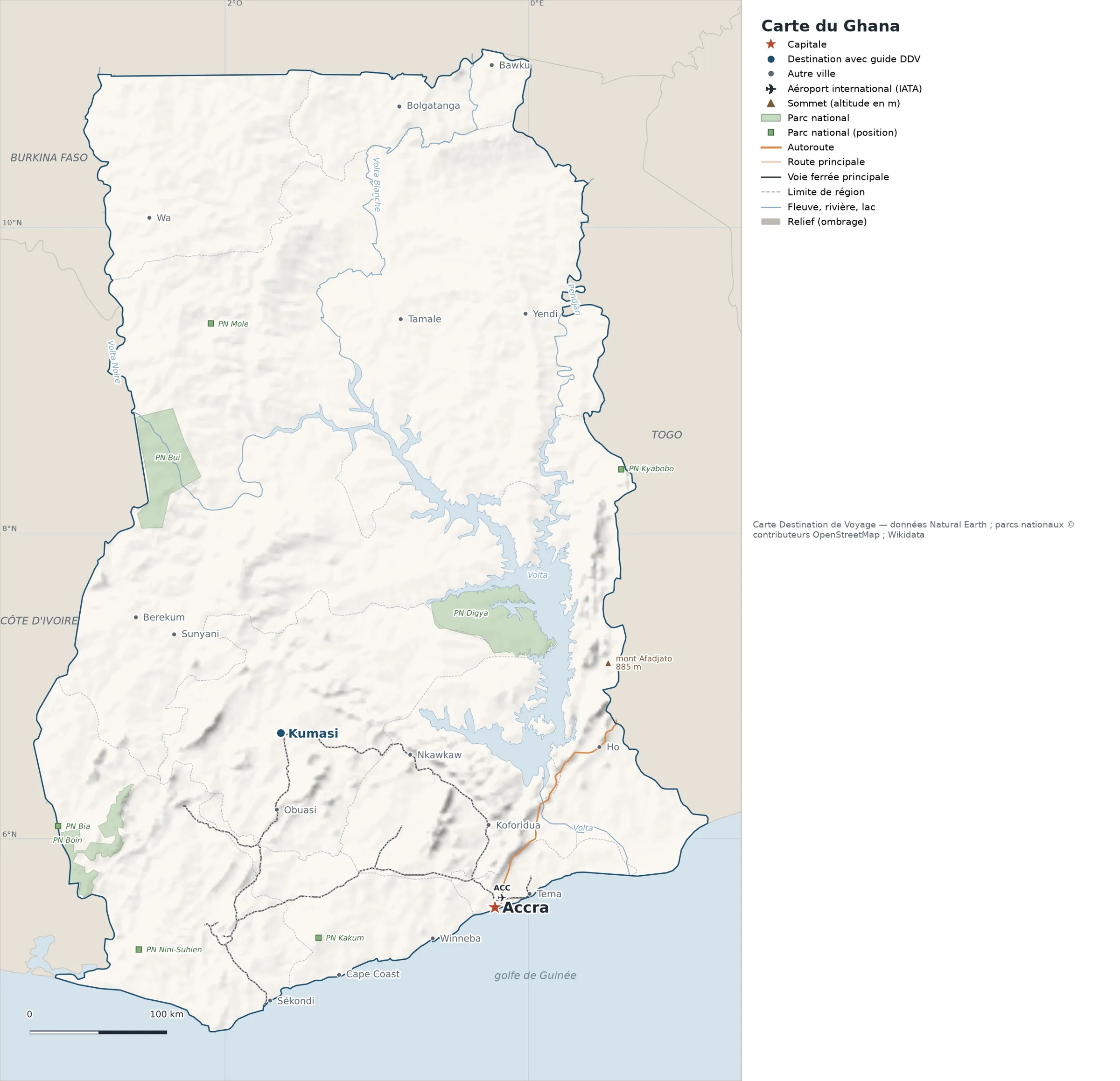
Open the full-size map (high resolution, zoomable)
Key: red star = capital; blue dot = destination covered by a Destination de Voyage guide; blue italic name = region or island with a guide; grey dot = other city; plane = international airport (IATA code); brown triangle = summit (elevation); green areas = national parks (green square = national park shown as a point); thick orange line = expressway, light orange = main road; black-and-white line = main railway; grey dashes = regional boundaries; blue = rivers and lakes; shading = terrain; grid = latitude and longitude.
Sources: base map, cities, roads, railways, airports, administrative boundaries, rivers, lakes and hillshading: Natural Earth 1:10m (public domain). National parks: © OpenStreetMap contributors (ODbL licence) and Wikidata. Summits and elevations: Wikidata and Natural Earth. Places missing from Natural Earth: Wikipedia coordinates. Map produced by Destination de Voyage.
Regions and destinations on the map of Ghana
| Region | Our guides | Other cities on the map |
|---|---|---|
| Ashanti | Kumasi | Obuasi |
| Greater Accra | Accra | Tema |
| Brong Ahafo | — | Berekum |
| Western Region | — | Sekondi |
| Eastern Region | — | Koforidua |
| Central Region | — | Cape Coast |
| Volta | — | Ho |
Straight-line distances between the main cities
Straight-line distances calculated from the coordinates of the places (haversine formula). Actual journeys by road, rail, boat or plane are longer.
| Route | Straight-line distance |
|---|---|
| Accra – Kumasi | 201 km (125 mi) |
| Accra – Sekondi | 178 km (111 mi) |
| Accra – Tema | 27 km (17 mi) |
| Accra – Obuasi | 175 km (109 mi) |
| Accra – Koforidua | 60 km (37 mi) |
| Accra – Cape Coast | 124 km (77 mi) |
| Accra – Ho | 139 km (86 mi) |
| Accra – Nkawkaw | 127 km (79 mi) |
Terrain, national parks and airports
National parks shown (3): Digya National Park, Kakum National Park, Nini-Suhien National Park.
International airports shown: ACC (Kotoka).
Our guides by destination
Frequently asked questions
What is the capital of Ghana?
Accra, marked by the red star on the map.
Which of our guide destinations is farthest from Accra?
Kumasi, about 201 km (125 mi) in a straight line (Destination de Voyage calculation).
Which countries border Ghana?
Countries sharing a land border: Burkina Faso, Côte d’Ivoire and Togo.
Which international airports are on the map?
ACC (Kotoka).