
This map of Kenya shows the capital (Nairobi), the destination covered in our guides and the main cities, with terrain, national parks, expressways, railways, rivers and international airports.
Neighbouring countries (land border): Uganda, Somalia, South Sudan, Tanzania and Ethiopia. Its coasts face: Indian Ocean.

Our travel deals for Map
Affiliate links: we earn a commission, at no extra cost to you.
 FlightsKiwi.comCompare flights and airline combinations to Map.Compare flights
- eSIMAiraloData plan to install before you leave (eSIM-compatible phone).See plans


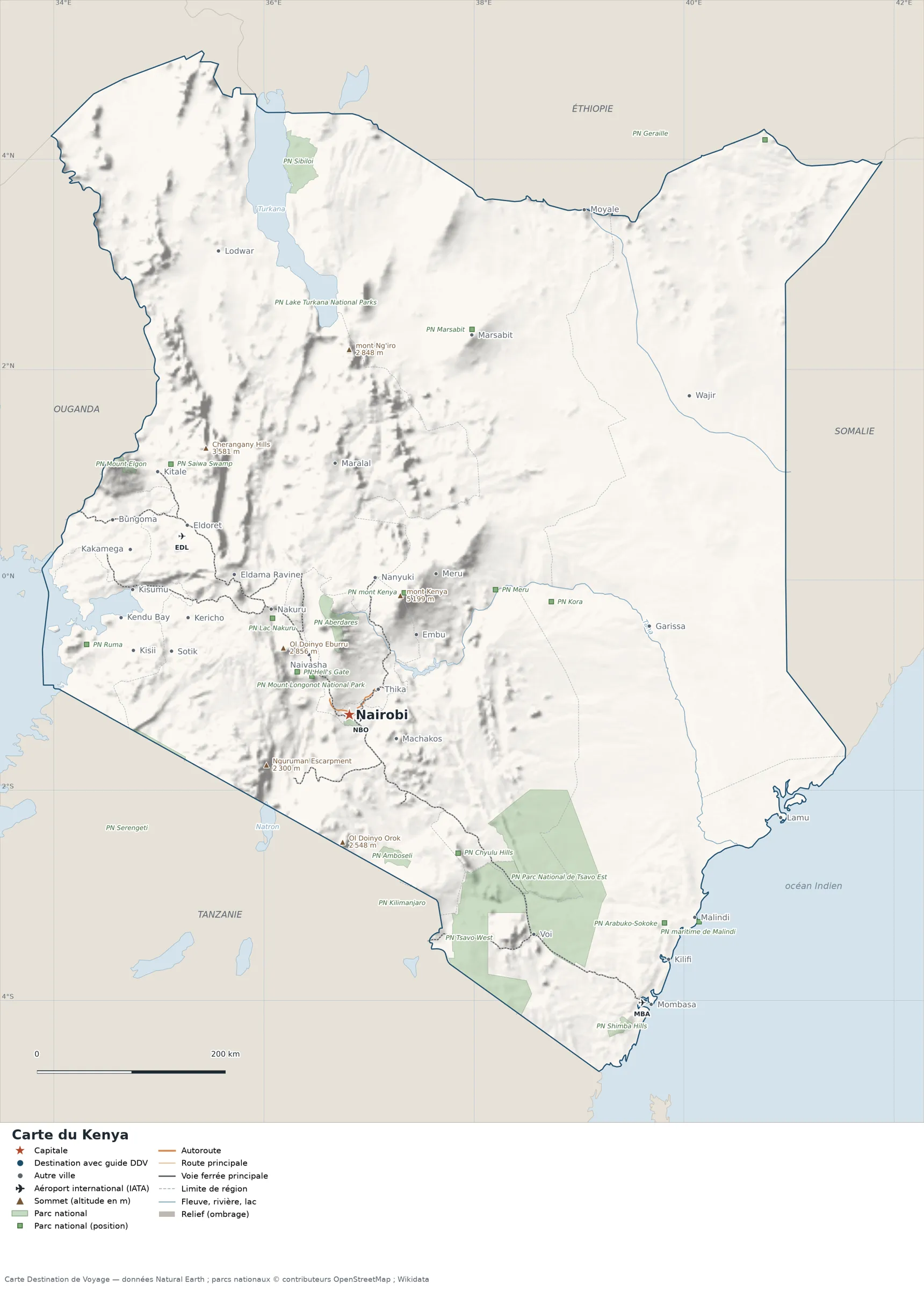
Open the full-size map (high resolution, zoomable)
Key: red star = capital; blue dot = destination covered by a Destination de Voyage guide; blue italic name = region or island with a guide; grey dot = other city; plane = international airport (IATA code); brown triangle = summit (elevation); green areas = national parks (green square = national park shown as a point); thick orange line = expressway, light orange = main road; black-and-white line = main railway; grey dashes = regional boundaries; blue = rivers and lakes; shading = terrain; grid = latitude and longitude.
Sources: base map, cities, roads, railways, airports, administrative boundaries, rivers, lakes and hillshading: Natural Earth 1:10m (public domain). National parks: © OpenStreetMap contributors (ODbL licence) and Wikidata. Summits and elevations: Wikidata and Natural Earth. Places missing from Natural Earth: Wikipedia coordinates. Map produced by Destination de Voyage.

Regions and destinations on the map of Kenya
| Region | Our guides | Other cities on the map |
|---|---|---|
| Nairobi | Nairobi | — |
| Coast | — | Mombasa |
| Nyanza | — | Kisumu |
| Rift Valley | — | Eldoret |
| Central | — | Thika |
| North Eastern | — | Garissa |
| Western | — | Kakamega |
| Eastern | — | Meru |
Straight-line distances between the main cities
Straight-line distances calculated from the coordinates of the places (haversine formula). Actual journeys by road, rail, boat or plane are longer.
| Route | Straight-line distance |
|---|---|
| Nairobi – Mombasa | 442 km (275 mi) |
| Nairobi – Eldoret | 264 km (164 mi) |
| Nairobi – Meru | 175 km (109 mi) |
| Nairobi – Kisumu | 265 km (165 mi) |
| Nairobi – Nakuru | 139 km (86 mi) |
| Nairobi – Malindi | 423 km (263 mi) |
| Nairobi – Moyale | 589 km (366 mi) |
| Nairobi – Lamu | 469 km (291 mi) |
Terrain, national parks and airports
Main summits (elevations from Wikidata / Natural Earth): Mount Kenya (5,199 m / 17,057 ft), Mount Satima (4,001 m / 13,127 ft), Mount Kinangop (3,906 m / 12,815 ft), Cherangany Hills (3,581 m / 11,749 ft) and Mount Mtelo (3,336 m / 10,945 ft).
National parks shown (25): Aberdares National Park, Amboseli National Park, Geraille National Park, Kilimanjaro National Park, Lake Turkana National Parks, Mount Elgon National Park, Mount Longonot National Park, Tsavo Est National Park, Nairobi National Park, Shimba Hills National Park, Serengeti National Park, Sibiloi National Park, Tsavo West National Park, Arabuko-Sokoke National Park, Hell’s Gate National Park, Kora National Park, Malka Mari National Park, Marsabit National Park, Meru National Park, Ruma National Park, Saiwa Swamp National Park, Chyulu Hills National Park, Lake Nakuru National Park, Mount Kenya National Park and Malindi Marine National Park.
International airports shown: EDL (Eldoret), MBA (Moi), NBO (Jomo Kenyatta).
Our guides by destination
Frequently asked questions
What is the capital of Kenya?
Nairobi, marked by the red star on the map.
Which countries border Kenya?
Countries sharing a land border: Uganda, Somalia, South Sudan, Tanzania and Ethiopia.
What is the highest summit shown on the map?
Mount Kenya, at an elevation of 5,199 m / 17,057 ft (source: Natural Earth).
Which international airports are shown on the map?
EDL (Eldoret), MBA (Moi), NBO (Jomo Kenyatta).