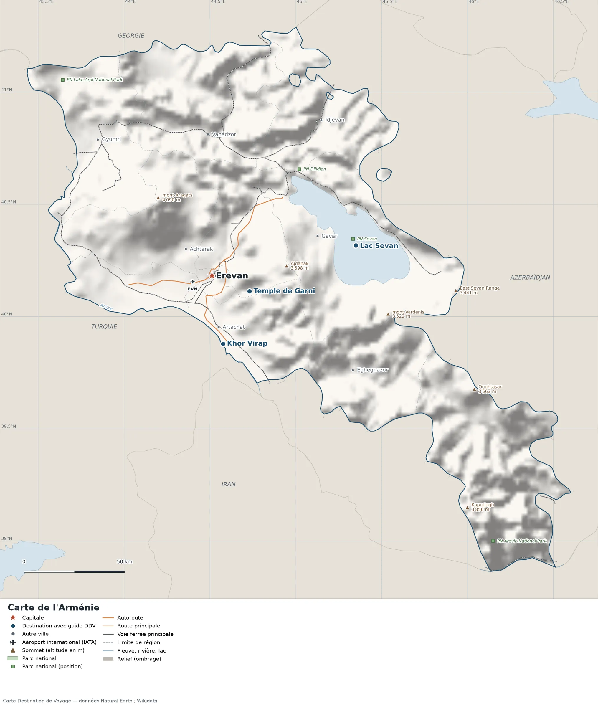
This map of Armenia shows the capital, Yerevan, the 4 destinations covered in our guides and the main towns, with the terrain, national parks, expressways, railways, rivers and international airports.

Our travel deals for Map
Affiliate links: we earn a commission, at no extra cost to you.
 FlightsKiwi.comCompare flights and airline combinations to Map.Compare flights
- eSIMSailyAnother eSIM plan to compare: data, validity, network.See Saily plans


Safety (UK FCDO and U.S. Department of State, read on 12 November 2026): the UK FCDO (GOV.UK, updated 1 March 2026) advises against all travel to within 5 km (3 mi) of the entire eastern border between Armenia and Azerbaijan, which remains closed, and against all travel along the M16/H26 road between Ijevan and Noyemberyan, because of tensions between the two countries. The U.S. Department of State rates Armenia Level 2, Exercise Increased Caution (travel advisory dated September 4, 2025), and says Do Not Travel to the border region with Azerbaijan; it also says that US Embassy employees and their families cannot travel for non-essential reasons to the Gegharkunik region east of Vardenis or to the Syunik region east of Goris and south of Kapan. Sources: GOV.UK, Armenia travel advice and travel.state.gov, Armenia (page last updated September 10, 2026).
Places, summits and parks located in these areas remain drawn on the map for geographical reference, but we do not mention or recommend them.
Neighbouring countries (land border): Azerbaijan, Georgia, Iran and Turkey.
Open the full-size map (high resolution, zoomable)
Key: red star = capital; blue dot = destination covered by a Destination de Voyage guide; blue italic name = region or island with a guide; grey dot = other city; plane = international airport (IATA code); brown triangle = summit (elevation); green areas = national parks (green square = national park shown as a point); thick orange line = expressway, light orange = main road; black-and-white line = main railway; grey dashes = regional boundaries; blue = rivers and lakes; shading = terrain; grid = latitude and longitude.
Sources: base map, cities, roads, railways, airports, administrative boundaries, rivers, lakes and hillshading: Natural Earth 1:10m (public domain). National parks: Wikidata. Summits and elevations: Wikidata and Natural Earth. Places missing from Natural Earth: Wikipedia coordinates. Map produced by Destination de Voyage.
Regions and destinations on the map of Armenia
| Region | Our guides | Other cities on the map |
|---|---|---|
| Ararat | Khor Virap | Artashat |
| Yerevan | Yerevan | — |
| Gegharkunik | Lake Sevan | Gavar |
| Kotayk | Garni Temple | — |
| Aragatsotn | — | Ashtarak |
| Lori | — | Vanadzor |
| Shirak | — | Gyumri |
Straight-line distances between the main cities
Straight-line distances calculated from the coordinates of the places (haversine formula). Actual journeys by road, rail, ferry or air are longer.
| Route | Straight-line distance |
|---|---|
| Yerevan – Lake Sevan | 73 km (45 mi) |
| Yerevan – Khor Virap | 34 km (21 mi) |
| Yerevan – Garni Temple | 20 km (12 mi) |
| Yerevan – Gyumri | 88 km (55 mi) |
| Yerevan – Vanadzor | 70 km (43 mi) |
| Yerevan – Gavar | 56 km (35 mi) |
| Yerevan – Artashat | 26 km (16 mi) |
| Lake Sevan – Garni Temple | 57 km (35 mi) |
| Khor Virap – Garni Temple | 29 km (18 mi) |
Terrain, national parks and airports
Main summits (elevations from Wikidata / Natural Earth): Mount Aragats (4,090 m / 13,419 ft), Ajdahak (3,598 m / 11,804 ft).
National parks shown (3): Lake Arpi National Park, Dilijan National Park, Sevan National Park.
International airports shown: EVN (Zvartnots).
Our guides by destination
Frequently asked questions
What is the capital of Armenia?
Yerevan, shown by the red star on the map.
What is the destination in our guides farthest from Yerevan?
Lake Sevan, about 73 km (45 mi) in a straight line (Destination de Voyage calculation).
Which countries border Armenia?
Countries sharing a land border: Azerbaijan, Georgia, Iran and Turkey.
What is the highest summit shown on the map?
Mount Aragats, at 4,090 m (13,419 ft) (source: Natural Earth).
Which international airports are on the map?
EVN (Zvartnots).