
This map of Laos shows the capital, Vientiane, the main cities, with terrain, national parks, railways and rivers.
Bordering countries (land border): Myanmar, Cambodia, China, Thailand and Vietnam.

Our travel deals for Map
Affiliate links: we earn a commission, at no extra cost to you.
 FlightsKiwi.comCompare flights and airline combinations to Map.Compare flights
- eSIMAiraloData plan to install before you leave (eSIM-compatible phone).See plans


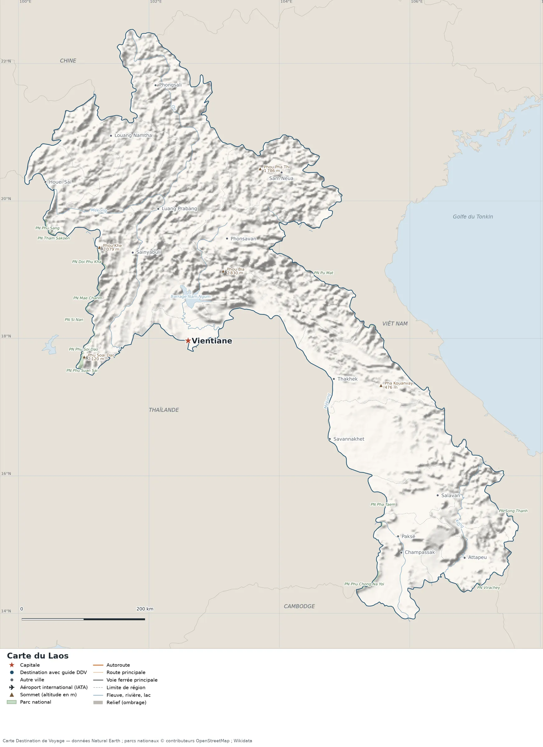
Open the full-size map (high resolution, zoomable)
Key: red star = capital; blue dot = destination covered by a Destination de Voyage guide; blue italic name = region or island with a guide; grey dot = other city; plane = international airport (IATA code); brown triangle = summit (elevation); green areas = national parks; thick orange line = expressway, light orange = main road; black-and-white line = main railway; grey dashes = regional boundaries; blue = rivers and lakes; shading = terrain; grid = latitude and longitude.
Sources: base map, cities, roads, railways, airports, administrative boundaries, rivers, lakes and hillshading: Natural Earth 1:10m (public domain). National parks: © OpenStreetMap contributors (ODbL licence). Summits and elevations: Wikidata and Natural Earth. Places missing from Natural Earth: Wikipedia coordinates. Map produced by Destination de Voyage.
Regions and destinations on the map of Laos
| Region | Our guides | Other cities on the map |
|---|---|---|
| Attapeu | — | Attapeu |
| Bokeo | — | Houayxay |
| Champassak | — | Pakse |
| Houaphan | — | Sam Neua |
| Khammouane | — | Thakhek |
| Luang Namtha | — | Luang Namtha |
| Luang Prabang | — | Luang Prabang |
| Phongsaly | — | Phongsali |
| Saravane | — | Salavan |
| Savannakhet | — | Savannakhet |
| Sayaboury | — | Sainyabuli |
| Vientiane | — | Vientiane |
| Xieng Khouang | — | Phonsavan |
Straight-line distances between the main cities
Straight-line distances calculated from the coordinates of each place (haversine formula). Actual journeys by road, rail, ferry or plane are longer.
| Route | Straight-line distance |
|---|---|
| Vientiane – Savannakhet | 280 km (174 mi) |
| Vientiane – Luang Prabang | 219 km (136 mi) |
| Vientiane – Pakse | 467 km (290 mi) |
| Vientiane – Thakhek | 245 km (152 mi) |
| Vientiane – Phonsavan | 177 km (110 mi) |
| Vientiane – Sainyabuli | 169 km (105 mi) |
| Vientiane – Sam Neua | 311 km (193 mi) |
| Vientiane – Champassak | 489 km (304 mi) |
Terrain, national parks and airports
Main summits (elevations from Wikidata / Natural Earth): Phou Bia (2,830 m / 9,285 ft), Phu Soai Dao (2,120 m / 6,955 ft), Phou Khe (2,079 m / 6,821 ft), Phou Pha Thi (1,786 m / 5,860 ft), Pha Kouanvay (476 m / 1,562 ft).
National parks shown (15): Doi Phu Kha National Park, Kaeng Tana National Park, Khun Nan National Park, Mae Charim National Park, Pha Taem National Park, Phu Chong-Na Yoi National Park, Phu Sang National Park, Phu Soi Dao National Park, Phu Suan Sai National Park, Pu Mat National Park, Si Nan National Park, Song Thanh National Park, Tham Sakoen National Park, Virachey National Park, Vu Quang National Park.
Our guide
The 17 regions of Laos and what sets them apart
The Natural Earth base map divides Laos into 17 first-level subdivisions (type: Kampeng Nakhon and Khoueng). These are the grey dashed boundaries on the map. The table ranks them from largest to smallest, with the cities, the highest point and the international airports that the map places in each.
| Region | Type | Area | Cities and guides | Highest point shown | Airport |
|---|---|---|---|---|---|
| Savannakhet | Khoueng | 21,113 km² (8,152 sq mi) | Savannakhet | — | — |
| Vientiane | Khoueng | 20,138 km² (7,775 sq mi) | — | Phou Bia (2,830 m / 9,285 ft) | — |
| Luang Prabang | Khoueng | 19,802 km² (7,646 sq mi) | Luang Prabang | — | — |
| Houaphan | Khoueng | 17,266 km² (6,666 sq mi) | Sam Neua | Phou Pha Thi (1,786 m / 5,860 ft) | — |
| Sayaboury | Khoueng | 16,597 km² (6,408 sq mi) | Sainyabuli | Phu Soai Dao (2,120 m / 6,955 ft) | — |
| Khammouane | Khoueng | 15,999 km² (6,177 sq mi) | Thakhek | Pha Kouanvay (476 m / 1,562 ft) | — |
| Borikhamxay | Khoueng | 15,435 km² (5,959 sq mi) | — | — | — |
| Phongsaly | Khoueng | 15,277 km² (5,898 sq mi) | Phongsali | — | — |
| Champassak | Khoueng | 15,116 km² (5,836 sq mi) | Pakse, Champassak | — | — |
| Xieng Khouang | Khoueng | 12,400 km² (4,788 sq mi) | Phonsavan | — | — |
| Oudomxay | Khoueng | 11,630 km² (4,490 sq mi) | — | — | — |
| Saravane | Khoueng | 10,002 km² (3,862 sq mi) | Salavan | — | — |
| Luang Namtha | Khoueng | 9,662 km² (3,731 sq mi) | Luang Namtha | — | — |
| Attapeu | Khoueng | 9,182 km² (3,545 sq mi) | Attapeu | — | — |
| Sekong | Khoueng | 8,040 km² (3,104 sq mi) | — | — | — |
| Bokeo | Khoueng | 6,950 km² (2,683 sq mi) | Houayxay | — | — |
| Vientiane (capital) | Kampeng Nakhon | 3,505 km² (1,353 sq mi) | Vientiane | — | — |
- Largest: Savannakhet, about 21,113 km² (8,152 sq mi), or 9% of the mapped territory.
- Smallest: Vientiane, about 3,505 km² (1,353 sq mi).
- Capital region: Vientiane is in the Vientiane subdivision.
- Highest region: Vientiane, home to Phou Bia (2,830 m / 9,285 ft), the highest summit shown on the map.
How to read the map of Laos
- Extent: the mapped territory covers about 228,114 km² (88,075 sq mi) (Destination de Voyage calculation on the Natural Earth outline; Wikidata gives 236,800 km² / 91,429 sq mi). It extends from 13.92° N to 22.50° N in latitude and from 100.10° E to 107.66° E in longitude, about 954 km (593 mi) north to south and 799 km (496 mi) west to east (bounding rectangle, outlying territories included).
- Outline: the perimeter of the territory on the map (land borders) is about 4,389 km (2,727 mi). The simplified Natural Earth outline smooths out small detours: the real length of the borders is greater. Destination de Voyage calculation.
- Time zone (IANA tz database 2026b): Vientiane:
Asia/Vientiane(UTC+7, year-round). - Terrain: shading shows the terrain and brown triangles mark the summits. The highest shown are Phou Bia (2,830 m / 9,285 ft), Phu Soai Dao (2,120 m / 6,955 ft), Phou Khe (2,079 m / 6,821 ft), Phou Pha Thi (1,786 m / 5,860 ft), Doi Phi Pan Nam (1,745 m / 5,725 ft). Wikidata gives as highest point Phou Bia (2,819 m / 9,249 ft).
- Rivers (blue lines): Mekong (about 1,202 km / 747 mi drawn within the territory), Ou (about 394 km / 245 mi drawn within the territory), Nam Ngum (about 336 km / 209 mi drawn within the territory), Kong (about 303 km / 188 mi drawn within the territory), Ca (about 68 km / 42 mi drawn within the territory). Lengths measured on the simplified Natural Earth lines: Destination de Voyage calculation.
- Lakes named in Natural Earth: Nam Ngum Reservoir.
- National parks (green areas): 3 with their centre inside the territory, including Phu Sang National Park, Phu Soi Dao National Park and Phu Suan Sai National Park. Outlines from OpenStreetMap or position from Wikidata.
Distances between the main cities (cross table)
Straight-line distances between the capital, our destinations and the largest cities on the map, with the direction from the first city. Roads and ferries always add distance.
| Route | Straight-line distance | Direction |
|---|---|---|
| Vientiane → Luang Prabang | 219 km (136 mi) | north |
| Vientiane → Pakse | 467 km (290 mi) | southeast |
| Vientiane → Savannakhet | 280 km (174 mi) | southeast |
| Vientiane → Thakhek | 245 km (152 mi) | east |
| Vientiane → Sam Neua | 311 km (193 mi) | northeast |
| Vientiane → Phonsavan | 177 km (110 mi) | north |
| Luang Prabang → Pakse | 658 km (409 mi) | southeast |
| Luang Prabang → Savannakhet | 464 km (288 mi) | southeast |
| Luang Prabang → Thakhek | 395 km (245 mi) | southeast |
| Luang Prabang → Sam Neua | 206 km (128 mi) | east |
| Luang Prabang → Phonsavan | 120 km (75 mi) | southeast |
| Pakse → Savannakhet | 193 km (120 mi) | northwest |
| Pakse → Thakhek | 275 km (171 mi) | north |
| Pakse → Sam Neua | 618 km (384 mi) | north |
| Pakse → Phonsavan | 556 km (345 mi) | northwest |
| Savannakhet → Thakhek | 97 km (60 mi) | north |
| Savannakhet → Sam Neua | 438 km (272 mi) | north |
| Savannakhet → Phonsavan | 364 km (226 mi) | northwest |
Typical itineraries in Laos based on the map
- Our complete guide to Laos: must-sees, detailed itineraries and budget
- Best time to visit Laos: month-by-month climate
- For a trip combined with a neighbouring country: map of Cambodia, map of China and map of Thailand.
Frequently asked questions
What is the capital of Laos?
Vientiane, marked by the red star on the map.
Which countries border Laos?
Countries sharing a land border: Myanmar, Cambodia, China, Thailand and Vietnam.
What is the highest summit shown on the map?
Phou Bia, at an elevation of 2,830 m (9,285 ft), according to Natural Earth.
Where is Vientiane on the map of Laos?
At 17.97° N, 102.60° E, marked by the red star, in the Vientiane subdivision.
How many regions does Laos have?
Our map, based on Natural Earth, shows 17 first-level subdivisions (Kampeng Nakhon and Khoueng). Wikidata lists 17 entities of type “khoueng” attached directly to the territory; the official division may differ from the one on the map.
Where is Laos?
Continent: Asia (Wikidata). Laos lies in the northern hemisphere, east of the Greenwich meridian. Land borders: Myanmar, Cambodia, China, Thailand and Vietnam.
What is the area of Laos?
About 228,114 km² (88,075 sq mi) according to our calculation on the Natural Earth outline; Wikidata gives 236,800 km² (91,429 sq mi). The differences come from the precision of the coastline and of inland waters.
Our sources
- Natural Earth 1:10m (public domain): country and subdivision boundaries, cities, airports, rivers, lakes, terrain, at naturalearthdata.com.
- Wikidata, item Q819 (Laos): area, highest point, continent and subdivisions, accessed 23 October 2026.
- © OpenStreetMap contributors (ODbL licence): national park outlines.
- Wikidata: location of national parks and elevation of summits.
- Wikipedia: coordinates of places missing from Natural Earth.
- Destination de Voyage calculations: distances (haversine, radius 6,371 km), directions and areas (WGS84 ellipsoid, pyproj library).
- Our methodology