
This map of Germany shows the capital, Berlin, the 2 destinations covered in our guides and the main cities, with terrain, national parks, expressways, railways, rivers and international airports.
Neighbouring countries (land border): Austria, Belgium, Denmark, France, Luxembourg, the Netherlands, Poland, Switzerland and Czechia. Its coasts border Szczecin Lagoon, the Bay of Mecklenburg, the Baltic Sea and the North Sea.

Our travel deals for Map
Affiliate links: we earn a commission, at no extra cost to you.
 FlightsKiwi.comCompare flights and airline combinations to Map.Compare flights

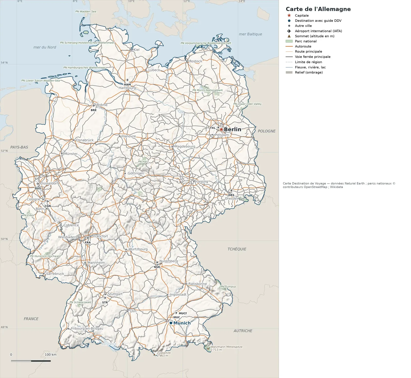
Open the full-size map (high resolution, zoomable)
Key: red star = capital; blue dot = destination covered by a Destination de Voyage guide; blue italic name = region or island with a guide; grey dot = other city; plane = international airport (IATA code); brown triangle = summit (elevation); green areas = national parks; thick orange line = expressway, light orange = main road; black-and-white line = main railway; grey dashes = regional boundaries; blue = rivers and lakes; shading = terrain; grid = latitude and longitude.
Sources: base map, cities, roads, railways, airports, administrative boundaries, rivers, lakes and hillshading: Natural Earth 1:10m (public domain). National parks: © OpenStreetMap contributors (ODbL licence). Summits and elevations: Wikidata and Natural Earth. Places missing from Natural Earth: Wikipedia coordinates. Map produced by Destination de Voyage.
Regions and destinations on the map of Germany
| Region | Our guides | Other cities on the map |
|---|---|---|
| Bavaria | Munich | Nuremberg, Würzburg, Regensburg, Ingolstadt |
| Berlin | Berlin | — |
| Baden-Württemberg | — | Stuttgart |
| Lower Saxony | — | Hanover |
| Brandenburg | — | Potsdam |
| Bremen | — | Bremen |
| Hamburg | — | Hamburg |
| Hesse | — | Frankfurt |
| Rhineland-Palatinate | — | Koblenz |
| North Rhine-Westphalia | — | Cologne |
| Saarland | — | Saarbrücken |
| Saxony | — | Dresden |
| Saxony-Anhalt | — | Magdeburg |
| Schleswig-Holstein | — | Kiel |
Straight-line distances between the main cities
Straight-line distances calculated from place coordinates (haversine formula). Actual journeys by road, rail, boat or plane are longer.
| Route | Straight-line distance |
|---|---|
| Berlin – Munich | 505 km (314 mi) |
| Berlin – Frankfurt | 425 km (264 mi) |
| Berlin – Hamburg | 255 km (158 mi) |
| Berlin – Dresden | 166 km (103 mi) |
| Berlin – Stuttgart | 511 km (318 mi) |
| Berlin – Cologne | 478 km (297 mi) |
| Berlin – Nuremberg | 378 km (235 mi) |
| Berlin – Bremen | 315 km (196 mi) |
Terrain, national parks and airports
Main summits (elevations from Wikidata / Natural Earth): Zugspitze (2,963 m / 9,721 ft), Watzmann Mittelspitze (2,713 m / 8,901 ft), Hochfrottspitze (2,649 m / 8,691 ft), Hochkarspitze (2,482 m / 8,143 ft).
National parks shown (20): Lower Oder Valley National Park, Lower Saxon Wadden Sea National Park, Müritz-Nationalpark, Nationalpark Berchtesgaden, Nationalpark Eifel, Nationalpark Hainich, Nationalpark Hamburgisches Wattenmeer, Nationalpark Harz, Nationalpark Hunsrück-Hochwald, Nationalpark Jasmund, Nationalpark Kellerwald-Edersee, Nationalpark Schleswig-Holsteinisches Wattenmeer, Nationalpark Schwarzwald, Nationalpark Vorpommersche Boddenlandschaft, Bohemian Switzerland National Park, Bavarian Forest National Park, Šumava National Park, Saxon Switzerland National Park, Ujście Warty National Park, Wadden Sea National Park.
International airports shown: BRE (Bremen), NUE (Nurnberg), DRS (Dresden), CGN (Cologne/Bonn), DUS (Düsseldorf), STR (Stuttgart), HAM (Hamburg), MUC (Franz-Josef-Strauss), MUCf (Munich Freight Terminal), TXL (Berlin-Tegel), FRA (Frankfurt).
Our guides by destination
Frequently asked questions
What is the capital of Germany?
Berlin, marked by the red star on the map.
Which of our guide destinations is farthest from Berlin?
Munich, about 505 km (314 mi) in a straight line (Destination de Voyage calculation).
Which countries border Germany?
Countries sharing a land border: Austria, Belgium, Denmark, France, Luxembourg, the Netherlands, Poland, Switzerland and Czechia.
What is the highest summit shown on the map?
Zugspitze, at 2,963 m (9,721 ft) elevation (source: Natural Earth).
Which international airports are on the map?
BRE (Bremen), NUE (Nurnberg), DRS (Dresden), CGN (Cologne/Bonn), DUS (Düsseldorf), STR (Stuttgart), HAM (Hamburg), MUC (Franz-Josef-Strauss), MUCf (Munich Freight Terminal), TXL (Berlin-Tegel), FRA (Frankfurt).