
This map of Latvia shows the capital, Riga, the destination covered in our guides and the main cities, with terrain, national parks, main roads, railways, rivers and international airports.
Countries sharing a land border: Belarus, Estonia, Lithuania and Russia. Its coastline faces: Gulf of Riga and Baltic Sea.

Our travel deals for Map
Affiliate links: we earn a commission, at no extra cost to you.
 Learn the languageTargumiLearn a few words of Latvian before you go — 30% off via our link.See the course
- FlightsKiwi.comCompare flights and airline combinations to Map.Compare flights


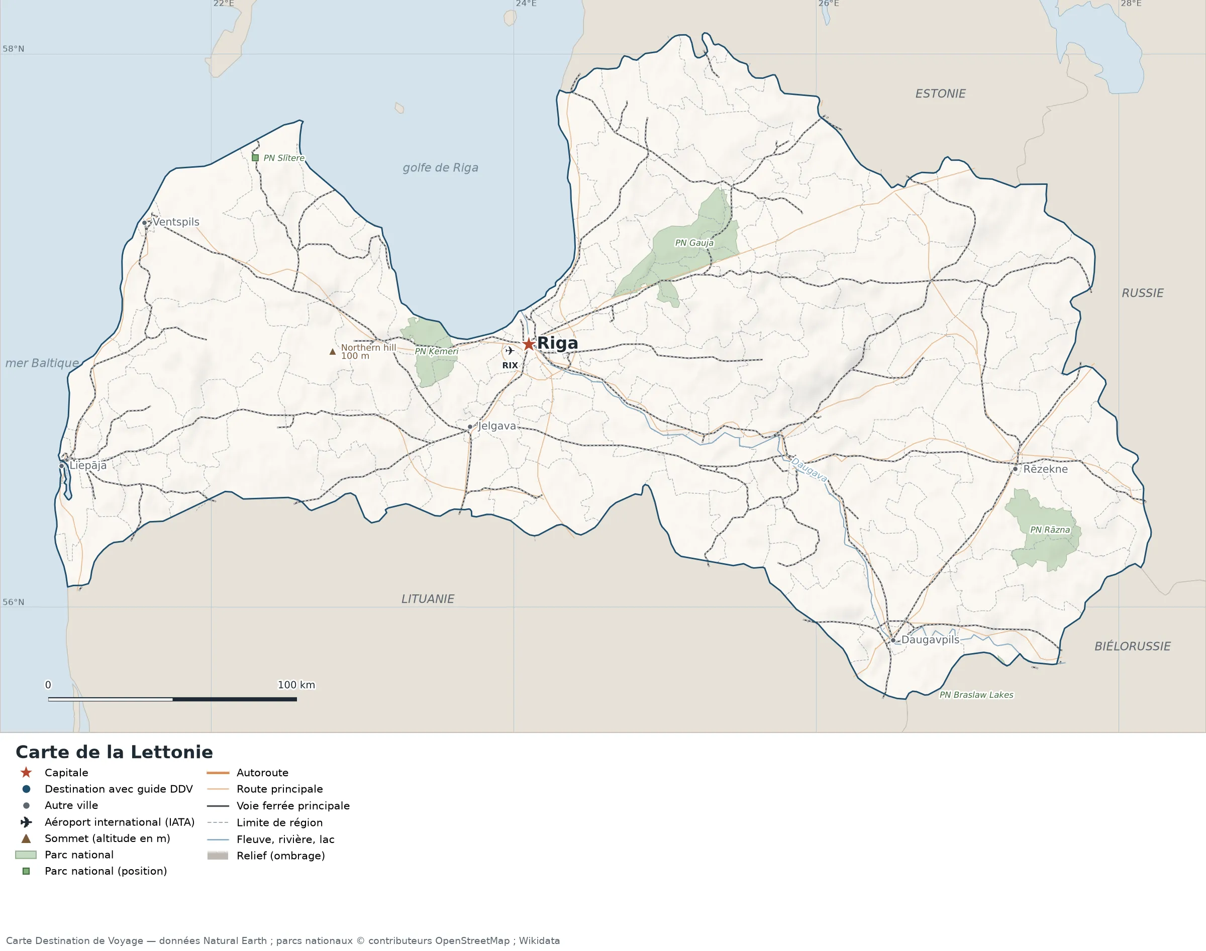
Open the full-size map (high resolution, zoomable)
Key: red star = capital; blue dot = destination covered by a Destination de Voyage guide; blue italic name = region or island with a guide; grey dot = other city; plane = international airport (IATA code); brown triangle = summit (elevation); green areas = national parks (green square = national park located by a single point); thick orange line = expressway, light orange = main road; black-and-white line = main railway; grey dashes = regional boundaries; blue = rivers and lakes; shading = terrain; grid = latitude and longitude.
Sources: base map, cities, roads, railways, airports, administrative boundaries, rivers, lakes and hillshading: Natural Earth 1:10m (public domain). National parks: © OpenStreetMap contributors (ODbL licence) and Wikidata. Summits and elevations: Wikidata and Natural Earth. Places missing from Natural Earth: Wikipedia coordinates. Map produced by Destination de Voyage.
Regions and destinations on the map of Latvia
| Region | Our guides | Other cities on the map |
|---|---|---|
| Riga | Riga | — |
| Daugavpils | — | Daugavpils |
| Jelgava | — | Jelgava |
| Liepāja | — | Liepāja |
| Rēzekne | — | Rēzekne |
| Ventspils | — | Ventspils |
Straight-line distances between the main cities
Straight-line distances calculated from the coordinates of the places (haversine formula). Actual journeys by road, rail, ferry or air are longer.
| Route | Straight-line distance |
|---|---|
| Riga – Daugavpils | 190 km (118 mi) |
| Riga – Liepāja | 195 km (121 mi) |
| Riga – Jelgava | 41 km (25 mi) |
| Riga – Ventspils | 161 km (100 mi) |
| Riga – Rēzekne | 202 km (126 mi) |
Terrain, national parks and airports
Main summits (elevations from Wikidata / Natural Earth): Northern hill (100 m / 328 ft).
National parks shown (5): Braslaw Lakes National Park, Gauja National Park, Rāzna National Park, Slītere National Park, Ķemeri National Park.
International airports shown: RIX (Riga).
Our guides by destination
The 119 regions of Latvia and what sets them apart
The Natural Earth base map divides Latvia into 119 first-level subdivisions (type: Novads and Republikas Pilsētas). These are the grey dashed boundaries on the map. The table ranks them from largest to smallest, with the cities, the highest point and the international airports the map places in each. Only the 22 largest are listed.
| Region | Type | Area | Cities and guides | Highest point shown | Airport |
|---|---|---|---|---|---|
| Rēzekne | Novads | 2,526 km² (975 sq mi) | — | — | — |
| Ventspils | Novads | 2,434 km² (940 sq mi) | — | — | — |
| Madona | Novads | 2,145 km² (828 sq mi) | — | — | — |
| Gulbene | Novads | 1,862 km² (719 sq mi) | — | — | — |
| Daugavpils | Novads | 1,807 km² (698 sq mi) | — | — | — |
| Kuldīga | Novads | 1,762 km² (680 sq mi) | — | — | — |
| Talsi Municipality | Novads | 1,747 km² (675 sq mi) | — | — | — |
| Alūksne | Novads | 1,665 km² (643 sq mi) | — | — | — |
| Saldus | Novads | 1,652 km² (638 sq mi) | — | — | — |
| Jelgava | Novads | 1,322 km² (510 sq mi) | — | — | — |
| Limbaži | Novads | 1,176 km² (454 sq mi) | — | — | — |
| Tukums | Novads | 1,172 km² (453 sq mi) | — | — | — |
| Krāslava | Novads | 1,038 km² (401 sq mi) | — | — | — |
| Ogre | Novads | 1,017 km² (393 sq mi) | — | — | — |
| Balvi | Novads | 994 km² (384 sq mi) | — | — | — |
| Ludza | Novads | 966 km² (373 sq mi) | — | — | — |
| Valmiera | Novads | 954 km² (368 sq mi) | — | — | — |
| Jēkabpils | Novads | 921 km² (356 sq mi) | — | — | — |
| Dobele | Novads | 905 km² (349 sq mi) | — | — | — |
| Dagda | Novads | 890 km² (344 sq mi) | — | — | — |
| Vecumnieki | Novads | 873 km² (337 sq mi) | — | — | — |
| Valka | Novads | 858 km² (331 sq mi) | — | — | — |
- Largest: Rēzekne, about 2,526 km² (975 sq mi), or 4% of the mapped territory.
- Smallest: Valmiera, about 23 km² (9 sq mi).
- Capital region: Riga is in the Riga subdivision.
- Highest region: Kandava, home to Northern hill (100 m / 328 ft), the highest summit shown on the map.
- Region best covered by our guides: Riga (Riga).
- Air access: the international airports on the map are spread across 2 of the 119 regions (Riga and Mārupes novads).
How to read the map of Latvia
- Extent: the mapped territory covers about 64,576 km² / 24,933 sq mi (Destination de Voyage calculation on the Natural Earth outline). It extends from 55.67° N to 58.08° N in latitude and from 20.97° E to 28.22° E in longitude, about 268 km (167 mi) north to south and 440 km (273 mi) west to east (bounding rectangle, remote territories included).
- Outline: the perimeter of the territory on the map (coasts and land borders) measures about 1,564 km (972 mi). The simplified Natural Earth outline smooths out small detours: the real length of the coastline is greater. Destination de Voyage calculation.
- Terrain: shading shows the relief and brown triangles mark the summits. The highest shown are Northern hill (100 m / 328 ft). Wikidata gives Gaiziņkalns (312 m / 1,024 ft) as the highest point.
- Rivers (blue lines): Daugava (about 330 km / 205 mi mapped in the territory). Lengths measured on the simplified Natural Earth outline: Destination de Voyage calculation.
- National parks (green areas): 4 with their centre inside the territory, including Gauja National Park, Rāzna National Park, Slītere National Park and Ķemeri National Park. Outlines from OpenStreetMap or position from Wikidata.
- International airports (plane icon): RIX (Riga, about 8.0 km / 5.0 mi from the centre of Riga). Straight-line distances: Destination de Voyage calculation.
Distances between the main cities (cross table)
Straight-line distances between the capital, our destinations and the largest cities on the map, with the direction from the first city. Road or ferry routes always add distance.
| Route | Straight-line distance | Direction |
|---|---|---|
| Riga → Daugavpils | 190 km (118 mi) | southeast |
| Riga → Liepāja | 195 km (121 mi) | west |
| Riga → Jelgava | 41 km (25 mi) | southwest |
| Riga → Ventspils | 161 km (100 mi) | west |
| Riga → Rēzekne | 202 km (126 mi) | east |
| Daugavpils → Liepāja | 347 km (216 mi) | west |
| Daugavpils → Jelgava | 193 km (120 mi) | northwest |
| Daugavpils → Ventspils | 346 km (215 mi) | northwest |
| Daugavpils → Rēzekne | 85 km (53 mi) | northeast |
| Liepāja → Jelgava | 166 km (103 mi) | east |
| Liepāja → Ventspils | 103 km (64 mi) | north |
| Liepāja → Rēzekne | 387 km (240 mi) | east |
| Jelgava → Ventspils | 154 km (96 mi) | northwest |
| Jelgava → Rēzekne | 221 km (137 mi) | east |
| Ventspils → Rēzekne | 363 km (226 mi) | east |
Sample itineraries for Latvia from the map
Our guide covers one destination on the map: Riga. Combine it with the capital and the cities in the distance table.
- Our complete guide to Latvia: must-sees, detailed itineraries and budget
Frequently asked questions
What is the capital of Latvia?
Riga, marked by the red star on the map.
Which countries border Latvia?
Countries sharing a land border: Belarus, Estonia, Lithuania and Russia.
What is the highest summit shown on the map?
Northern hill, at an elevation of 100 m (328 ft) (source: Wikidata).
Which international airports are on the map?
RIX (Riga).
Where is Riga on the map of Latvia?
At 56.95° N, 24.10° E, marked by the red star, in the Riga subdivision.
How many regions does Latvia have?
Our map, based on Natural Earth, shows 119 first-level subdivisions (Novads and Republikas Pilsētas). Wikidata lists 34 entities of type “municipality of Latvia” attached directly to the territory; the official division may differ from the map.
Where is Latvia?
Continent: Europe (Wikidata). Latvia lies in the northern hemisphere, east of the Greenwich meridian. Coasts: Gulf of Riga and Baltic Sea. Land borders: Belarus, Estonia, Lithuania and Russia.
What is the area of Latvia?
About 64,576 km² (24,933 sq mi) by our calculation on the Natural Earth outline. The differences come from the precision of the coastline and inland waters.
Our sources
- Natural Earth 1:10m (public domain): country and subdivision boundaries, cities, airports, rivers, lakes and terrain, at naturalearthdata.com.
- Wikidata, item Q211 (Latvia): area, highest point, continent and subdivisions, accessed 23 October 2026.
- © OpenStreetMap contributors (ODbL licence): national park outlines.
- Wikidata: position of national parks and elevation of summits.
- Wikipedia (French edition): coordinates of places missing from Natural Earth.
- Destination de Voyage calculations: distances (haversine, radius 6,371 km / 3,959 mi), directions and areas (WGS84 ellipsoid, pyproj library).
- Our methodology