
This map of Bolivia shows the constitutional capital, Sucre, the seat of government, La Paz, the main cities, with terrain, national parks, expressways, railways, rivers and international airports.
Neighbouring countries (land border): Argentina, Brazil, Chile, Paraguay and Peru.

Our travel deals for Map
Affiliate links: we earn a commission, at no extra cost to you.
 FlightsKiwi.comCompare flights and airline combinations to Map.Compare flights
- eSIMSailyAnother eSIM plan to compare: data, validity, network.See Saily plans



Open the full-size map (high resolution, zoomable)
Key: red star = constitutional capital; white star circled in red = seat of government ; blue dot = destination covered by a Destination de Voyage guide ; blue italic name = region or island with a guide ; grey dot = other city ; plane = international airport (IATA code) ; brown triangle = summit (elevation) ; green areas = national parks (green square = national park located by a point) ; thick orange line = expressway, light orange = main road ; black-and-white line = main railway ; grey dashes = regional boundaries ; blue = rivers and lakes ; shading = terrain ; grid = latitude and longitude.
Sources: base map, cities, roads, railways, airports, administrative boundaries, rivers, lakes and hillshading: Natural Earth 1:10m (public domain). National parks: © OpenStreetMap contributors (ODbL licence) and Wikidata. Summits and elevations: Wikidata and Natural Earth. Places missing from Natural Earth: Wikipedia coordinates. Map produced by Destination de Voyage.
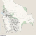
Regions and destinations on the map of Bolivia
| Region | Our guides | Other cities on the map |
|---|---|---|
| Beni | — | Riberalta |
| Chuquisaca | — | Sucre |
| Cochabamba | — | Cochabamba |
| La Paz | — | La Paz |
| Oruro | — | Oruro |
| Pando | — | Cobija |
| Potosí | — | Potosí |
| Santa Cruz | — | Santa Cruz de la Sierra |
| Tarija | — | Tarija |
Straight-line distances between the main cities
Straight-line distances calculated from place coordinates (haversine formula). Actual journeys by road, rail, boat or plane are longer.
| Route | Straight-line distance |
|---|---|
| Sucre – Santa Cruz de la Sierra | 258 km (160 mi) |
| Sucre – La Paz | 417 km (259 mi) |
| Sucre – Riberalta | 901 km (560 mi) |
| Sucre – Tarija | 280 km (174 mi) |
| Sucre – Trinidad | 469 km (291 mi) |
| Sucre – Cochabamba | 205 km (127 mi) |
| Sucre – Oruro | 230 km (143 mi) |
| Sucre – Cobija | 968 km (601 mi) |
Terrain, national parks and airports
Main summits (elevations from Wikidata / Natural Earth): Nevado Sajama (6,542 m / 21,463 ft), Illampu (6,485 m / 21,276 ft), Nevado Illimani (6,402 m / 21,004 ft), Huayna Potosí (6,088 m / 19,974 ft), Chaupi Orco (6,044 m / 19,829 ft).
National parks shown (22): Amboró National Park, Bahuaja Sonene National Park, Baritú National Park, El Cardón National Park and Integrated Management Natural Area, Lauca National Park, Madidi National Park, Noel Kempff Mercado National Park, Aguaragüe National Park, Carrasco National Park, Cotapata National Park, Iñao National Park, Kaa-Iya del Gran Chaco National Park, Mallasa National Park, Pantanal de Otuquis National Park, Salar del Huasco National Park, Volcán Isluga National Park, Sajama National Park, Isiboro Sécure Indigenous Territory and National Park, Torotoro National Park, Tunari National Park and Llica National Park.
International airports shown: SRE (Juana Azurduy de Padilla), LPB (El Alto), VVI (Viru Viru).
Our guide
Frequently asked questions
What is the capital of Bolivia?
Sucre is the constitutional capital (red star); La Paz is the seat of government (white star circled in red). Distance between the two: about 417 km (259 mi) in a straight line (Destination de Voyage calculation).
Which countries border Bolivia?
Countries sharing a land border: Argentina, Brazil, Chile, Paraguay and Peru.
What is the highest summit shown on the map?
Nevado Sajama, at an elevation of 6,542 m (21,463 ft) (source: Natural Earth).
Which international airports are on the map?
SRE (Juana Azurduy de Padilla), LPB (El Alto), VVI (Viru Viru).