
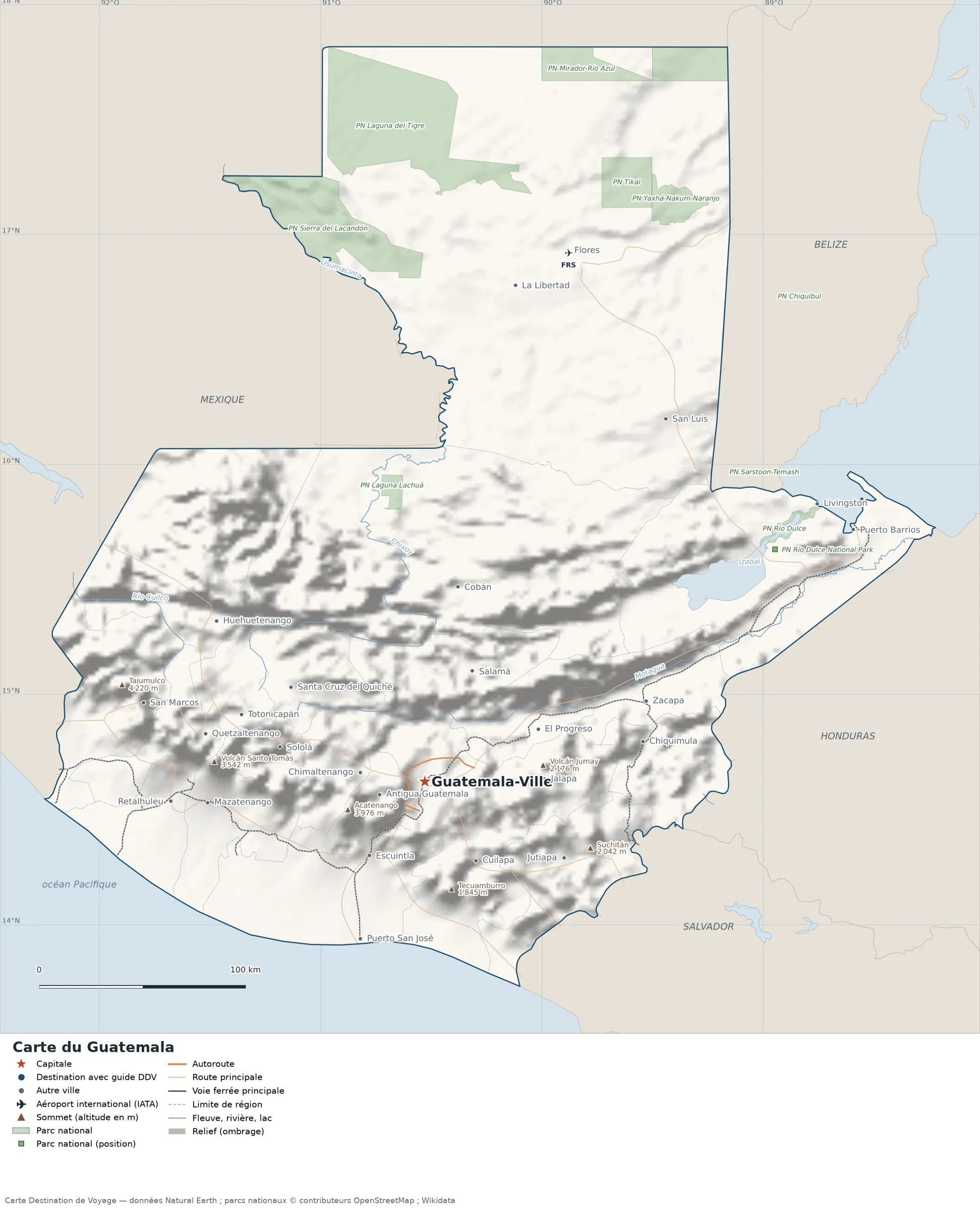
This map of Guatemala shows the capital, Guatemala City, the main cities, with terrain, national parks, expressways, railways, rivers and international airports.
Neighbouring countries (land border): Belize, Honduras, Mexico and El Salvador. Its coasts face: Gulf of Honduras and Pacific Ocean.

Our travel deals for Map
Affiliate links: we earn a commission, at no extra cost to you.
 FlightsKiwi.comCompare flights and airline combinations to Map.Compare flights
- eSIMSailyAnother eSIM plan to compare: data, validity, network.See Saily plans


Open the full-size map (high resolution, zoomable)
Key: red star = capital ; blue dot = destination covered by a Destination de Voyage guide ; blue italic name = region or island with a guide ; grey dot = other city ; plane = international airport (IATA code) ; brown triangle = summit (elevation) ; green areas = national parks (green square = national park located by a point) ; thick orange line = expressway, light orange = main road ; black-and-white line = main railway ; grey dashes = regional boundaries ; blue = rivers and lakes ; shading = terrain ; grid = latitude and longitude.
Sources: base map, cities, roads, railways, airports, administrative boundaries, rivers, lakes and hillshading: Natural Earth 1:10m (public domain). National parks: © OpenStreetMap contributors (ODbL licence) and Wikidata. Summits and elevations: Wikidata and Natural Earth. Places missing from Natural Earth: Wikipedia coordinates. Map produced by Destination de Voyage.
Regions and destinations on the map of Guatemala
| Region | Our guides | Other cities on the map |
|---|---|---|
| Alta Verapaz | — | Cobán |
| Chimaltenango | — | Chimaltenango |
| El Progreso | — | El Progreso |
| Escuintla | — | Escuintla |
| Guatemala | — | Guatemala City |
| Huehuetenango | — | Huehuetenango |
| Izabal | — | Puerto Barrios |
| Jalapa | — | Jalapa |
| Jutiapa | — | Jutiapa |
| Petén | — | Flores |
| Quetzaltenango | — | Quetzaltenango |
| Sololá | — | Sololá |
| Suchitepéquez | — | Mazatenango |
| Totonicapán | — | Totonicapán |
Straight-line distances between the main cities
Straight-line distances calculated from place coordinates (haversine formula). Actual journeys by road, rail, boat or plane are longer.
| Route | Straight-line distance |
|---|---|
| Guatemala City – Quetzaltenango | 109 km (68 mi) |
| Guatemala City – Puerto Barrios | 241 km (150 mi) |
| Guatemala City – Escuintla | 45 km (28 mi) |
| Guatemala City – Huehuetenango | 127 km (79 mi) |
| Guatemala City – Mazatenango | 106 km (66 mi) |
| Guatemala City – Flores | 266 km (165 mi) |
| Guatemala City – Puerto San José | 82 km (51 mi) |
| Guatemala City – La Libertad | 244 km (152 mi) |
Terrain, national parks and airports
Main summits (elevations from Wikidata / Natural Earth): Tajumulco (4,220 m / 13,845 ft), Acatenango (3,976 m / 13,045 ft), Volcán Santo Tomás (3,542 m / 11,621 ft), Volcán Jumay (2,176 m / 7,139 ft), Suchitán (2,042 m / 6,699 ft).
National parks shown (10): Chiquibul National Park, Laguna Lachuá National Park, Laguna del Tigre National Park, Yaxhá-Nakum-Naranjo National Park, Las Victorias National Park, Mirador-Río Azul National Park, Río Dulce National Park, Sarstoon-Temash National Park, Sierra del Lacandón National Park and Tikal National Park.
International airports shown: FRS (Mundo Maya).
Our guide
Frequently asked questions
What is the capital of Guatemala?
Guatemala City, marked by the red star on the map.
Which countries border Guatemala?
Countries sharing a land border: Belize, Honduras, Mexico and El Salvador.
What is the highest summit shown on the map?
Tajumulco, at an elevation of 4,220 m (13,845 ft) (source: Natural Earth).
Which international airports are on the map?
FRS (Mundo Maya).