
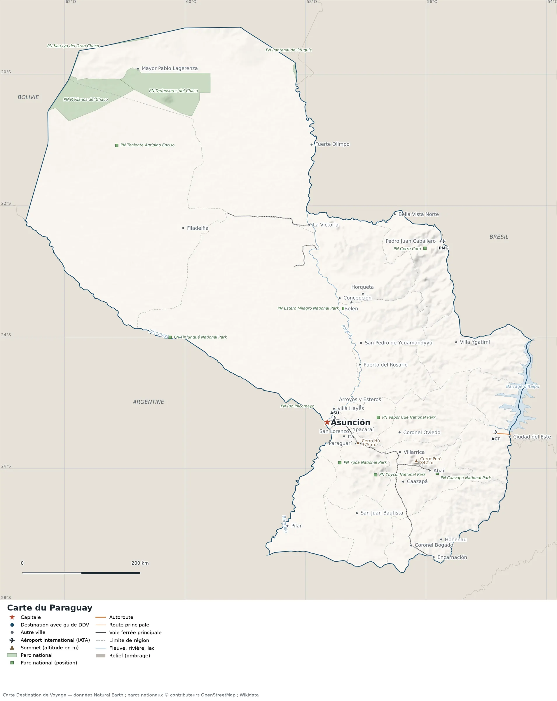
This map of Paraguay shows the capital, Asunción, the destination covered in our guides and the main cities, with the terrain, national parks, expressways, railways, rivers and international airports.

Our travel deals for Map
Affiliate links: we earn a commission, at no extra cost to you.
 FlightsKiwi.comCompare flights and airline combinations to Map.Compare flights
- eSIMSailyAnother eSIM plan to compare: data, validity, network.See Saily plans


Safety (UK FCDO, GOV.UK, updated 3 November 2026; U.S. Department of State, read on 12 November 2026): the U.S. Department of State rates Paraguay Level 1, Exercise Normal Precautions (travel advisory dated August 18, 2026), but advises increased caution in the departments of Alto Paraná, Amambay, Canindeyú, Concepción and San Pedro because of crime. The UK FCDO advises particular care in the departments bordering Brazil because of drug trafficking and rising violent crime, and warns that the Ejército del Pueblo Paraguayo (EPP) operates in the north of San Pedro and the south of Concepción. Sources: UK FCDO travel advice for Paraguay and U.S. Department of State, Paraguay country information.
Places, summits and parks inside these areas are still drawn on the map for geographic reference, but we do not mention or recommend them.
Neighboring countries (land borders): Argentina, Bolivia and Brazil.
Open the full-size map (high resolution, zoomable)
Key: red star = capital; blue dot = destination covered by a Destination de Voyage guide; blue italic name = region or island with a guide; grey dot = other city; plane = international airport (IATA code); brown triangle = summit (elevation); green areas = national parks (green square = national park shown as a point); thick orange line = expressway, light orange = main road; black-and-white line = main railway; grey dashes = regional boundaries; blue = rivers and lakes; shading = terrain; grid = latitude and longitude.
Sources: base map, cities, roads, railways, airports, administrative boundaries, rivers, lakes and hillshading: Natural Earth 1:10m (public domain). National parks: © OpenStreetMap contributors (ODbL licence) and Wikidata. Summits and elevations: Wikidata and Natural Earth. Places missing from Natural Earth: Wikipedia coordinates. Map produced by Destination de Voyage.
Regions and destinations on the map of Paraguay
| Region | Our guides | Other cities on the map |
|---|---|---|
| Asunción | Asunción | — |
| Alto Paraguay | — | La Victoria |
| Alto Paraná | — | Ciudad del Este |
| Boquerón | — | Filadelfia |
| Caaguazú | — | Coronel Oviedo |
| Caazapá | — | Abaí |
| Cordillera | — | Arroyos y Esteros |
| Guairá | — | Villarrica |
| Itapúa | — | Hohenau |
| Misiones | — | San Juan Bautista |
| Paraguarí | — | Paraguarí |
| Presidente Hayes | — | Villa Hayes |
| Central Department | — | Itá |
| Ñeembucú | — | Pilar |
Straight-line distances between the main cities
Straight-line distances calculated from the coordinates of the places (haversine formula). Actual journeys by road, rail, boat or plane are longer.
| Route | Straight-line distance |
|---|---|
| Asunción – Ciudad del Este | 305 km (190 mi) |
| Asunción – Villarrica | 132 km (82 mi) |
| Asunción – Filadelfia | 408 km (254 mi) |
| Asunción – Itá | 37 km (23 mi) |
| Asunción – Pilar | 187 km (116 mi) |
| Asunción – Hohenau | 274 km (170 mi) |
| Asunción – La Victoria | 335 km (208 mi) |
| Asunción – Abaí | 189 km (117 mi) |
Terrain, national parks and airports
Main summits (elevations from Wikidata / Natural Earth): Cerro Peró (842 m / 2,762 ft), Cerro Hú (375 m / 1,230 ft).
National parks shown (11): Caazapá National Park, Defensores del Chaco National Park, Teniente Agripino Enciso National Park, Kaa-Iya del Gran Chaco National Park, Médanos del Chaco National Park, Pantanal de Otuquis National Park, Río Pilcomayo National Park, Tinfunqué National Park, Vapor Cué National Park, Ybycuí National Park, Ypoá National Park.
International airports shown: PMG (Ponta Porã), AGT (Guaraní), ASU (Silvio Pettirossi).
Our guides by destination
Frequently asked questions
What is the capital of Paraguay?
Asunción, marked by the red star on the map.
Which countries border Paraguay?
Countries sharing a land border: Argentina, Bolivia and Brazil.
What is the highest summit shown on the map?
Cerro Peró, at 842 m (2,762 ft) (source: Natural Earth).
Which international airports are on the map?
PMG (Ponta Porã), AGT (Guaraní), ASU (Silvio Pettirossi).