This map of New Caledonia shows the main cities, with terrain and international airports.
New Caledonia has no land border with another country on our base map. Its coasts face: Coral Sea and Pacific Ocean.

Our travel deals for Map
Affiliate links: we earn a commission, at no extra cost to you.
 FlightsKiwi.comCompare flights and airline combinations to Map.Compare flights
- eSIMSailyAnother eSIM plan to compare: data, validity, network.See Saily plans


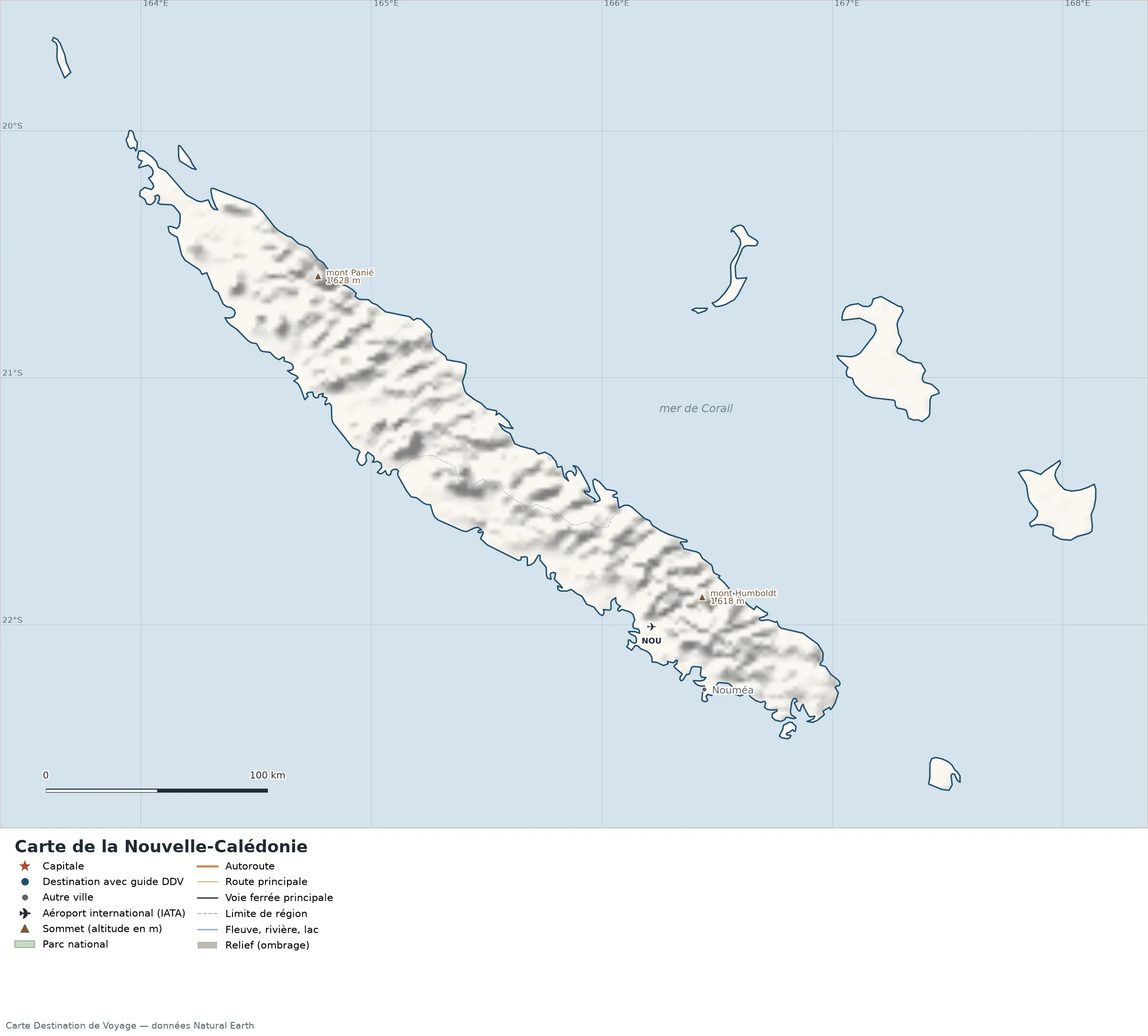
Open the full-size map (high resolution, zoomable)
Key: red star = capital; blue dot = destination covered by a Destination de Voyage guide; blue italic name = region or island with a guide; grey dot = other city; plane = international airport (IATA code); brown triangle = summit (elevation); green areas = national parks; thick orange line = expressway, light orange = main road; black-and-white line = main railway; grey dashes = regional boundaries; blue = rivers and lakes; shading = terrain; grid = latitude and longitude.
Sources: base map, cities, roads, railways, airports, administrative boundaries, rivers, lakes and hillshading: Natural Earth 1:10m (public domain). Summits and elevations: Wikidata and Natural Earth. Places missing from Natural Earth: Wikipedia coordinates. Map produced by Destination de Voyage.
Regions and destinations on the map of New Caledonia
| Region | Our guides | Other cities on the map |
|---|---|---|
| South Province | — | Nouméa |
Terrain, national parks and airports
Main summits (elevations from Wikidata / Natural Earth): Mont Panié (1,628 m / 5,341 ft), Mont Humboldt (1,618 m / 5,308 ft).
International airports shown: NOU (La Tontouta).
Our guide
The 3 regions of New Caledonia and what sets them apart
The Natural Earth base map divides New Caledonia into 3 first-level subdivisions (type: Province). These are the grey dashed boundaries on the map. The table ranks them from largest to smallest, with the cities, highest point and international airports the map places in each.
| Region | Type | Area | Cities and guides | Highest point shown | Airport |
|---|---|---|---|---|---|
| North Province | Province | 9,512 km² (3,673 sq mi) | — | Mont Panié (1,628 m / 5,341 ft) | — |
| South Province (capital) | Province | 7,313 km² (2,824 sq mi) | Nouméa | Mont Humboldt (1,618 m / 5,308 ft) | NOU |
| Loyalty Islands Province | Province | 2,016 km² (778 sq mi) | — | — | — |
- Largest: North Province, about 9,512 km² (3,673 sq mi), or 50% of the mapped territory.
- Smallest: Loyalty Islands Province, about 2,016 km² (778 sq mi).
- Capital region: Nouméa is in the South Province subdivision.
- Highest region: North Province, home to Mont Panié (1,628 m / 5,341 ft), the highest summit shown on the map.
- Air access: the international airports on the map are spread across 1 of the 3 regions (South Province).
How to read the map of New Caledonia
- Extent: the mapped territory covers about 18,841 km² (7,275 sq mi), calculated by Destination de Voyage on the Natural Earth outline; Wikidata gives 18,576 km² (7,172 sq mi). It spans 22.67° S to 19.62° S in latitude and 163.62° E to 171.34° E in longitude, about 339 km (211 mi) north to south and 801 km (498 mi) west to east (bounding rectangle, including distant territories).
- Outline: the perimeter of the territory on the map (coasts and land borders) is about 1,885 km (1,171 mi). The simplified Natural Earth outline smooths out small detours: the real length of the coastline is greater. Destination de Voyage calculation.
- Time zone (IANA tz database 2026b): Nouméa:
Pacific/Noumea(UTC+11, all year). Time difference and clock changes: time difference in New Caledonia. - Terrain: shading shows the terrain and brown triangles mark the summits. The highest shown are Mont Panié (1,628 m / 5,341 ft), Mont Humboldt (1,618 m / 5,308 ft).
- International airports (plane icon): NOU (La Tontouta, about 36 km / 22 mi from the centre of Nouméa). Straight-line distances: Destination de Voyage calculation.
Distances from Nouméa to the 32 other subdivisions
Subdivisions attached to the territory in Wikidata, ranked from nearest to farthest from Nouméa (straight-line distance to each subdivision’s reference point).
| Subdivision | Distance from Nouméa | Direction |
|---|---|---|
| Dumbéa | 13 km (8 mi) | north |
| Le Mont-Dore | 14 km (9 mi) | east |
| Païta | 17 km (11 mi) | north-west |
| Yaté | 53 km (33 mi) | east |
| Boulouparis | 61 km (38 mi) | north-west |
| Thio | 76 km (47 mi) | north |
| La Foa | 89 km (55 mi) | north-west |
| Canala | 96 km (60 mi) | north-west |
| Farino | 97 km (60 mi) | north-west |
| Moindou | 101 km (63 mi) | north-west |
| Sarraméa | 105 km (65 mi) | north-west |
| Isle of Pines (commune) | 111 km (69 mi) | east |
| Isle of Pines (island) | 115 km (71 mi) | south-east |
| Kouaoua | 116 km (72 mi) | north-west |
| Bourail | 127 km (79 mi) | north-west |
| Houaïlou | 139 km (86 mi) | north-west |
| Maré | 168 km (104 mi) | north-east |
| Poya | 169 km (105 mi) | north-west |
| Ponerihouen | 171 km (106 mi) | north-west |
| Poindimié | 188 km (117 mi) | north-west |
| Ouvéa | 203 km (126 mi) | north |
| Pouembout | 204 km (127 mi) | north-west |
| Touho | 207 km (129 mi) | north-west |
| Koné | 211 km (131 mi) | north-west |
| Voh | 232 km (144 mi) | north-west |
| Hienghène | 236 km (147 mi) | north-west |
| Kaala-Gomen | 277 km (172 mi) | north-west |
| Pouébo | 285 km (177 mi) | north-west |
| Koumac | 293 km (182 mi) | north-west |
| Ouégoa | 298 km (185 mi) | north-west |
| Poum | 339 km (211 mi) | north-west |
| Bélep | 407 km (253 mi) | north-west |
Typical itineraries in New Caledonia from the map
- Our complete guide to New Caledonia: must-sees, detailed itineraries and budget
- When to go to New Caledonia: best time to visit and month-by-month climate
- Time difference in New Caledonia: what time is it?
Frequently asked questions
What is the highest summit shown on the map?
Mont Panié, at an elevation of 1,628 m / 5,341 ft (source: Natural Earth).
Which international airports are on the map?
NOU (La Tontouta).
What is the capital of New Caledonia?
Nouméa (red star on the map), at 22.27° S and 166.45° E.
Where is Nouméa on the map of New Caledonia?
At 22.27° S and 166.45° E, marked by the red star, in the South Province subdivision.
How many regions does New Caledonia have?
Our map, based on Natural Earth, shows 3 first-level subdivisions (Province). Wikidata lists 30 entities of the type “commune of New Caledonia” attached directly to the territory; the official division may differ from the map’s.
Where is New Caledonia?
Continent: Oceania (Wikidata). New Caledonia lies in the southern hemisphere, east of the Greenwich meridian. Coasts: Coral Sea and Pacific Ocean.
What is the area of New Caledonia?
About 18,841 km² (7,275 sq mi) by our calculation on the Natural Earth outline; Wikidata gives 18,576 km² (7,172 sq mi). Differences come from the precision of the coastline and inland waters.
Our sources
- Natural Earth 1:10m (public domain): country and subdivision boundaries, cities, airports, rivers, lakes, terrain, on naturalearthdata.com.
- Wikidata, item Q33788 (New Caledonia): area, highest point, continent and subdivisions, accessed 23 October 2026.
- Wikipedia (French edition): coordinates of places missing from Natural Earth.
- Destination de Voyage calculations: distances (haversine, radius 6,371 km), directions and areas (WGS84 ellipsoid, pyproj library).
- Our methodology