
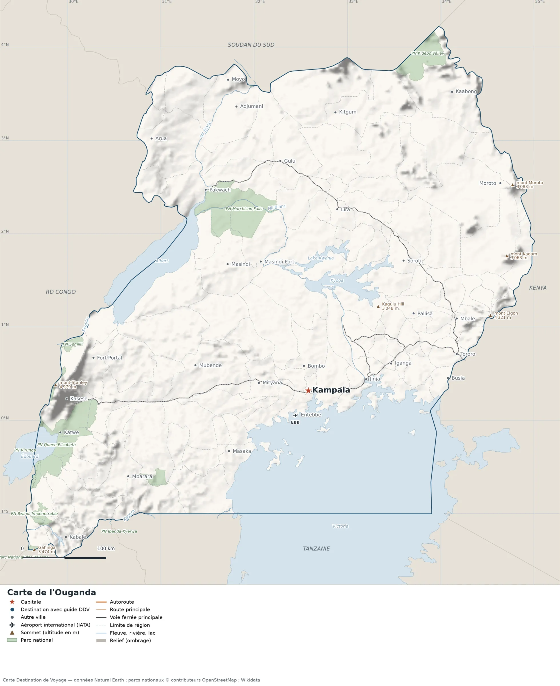
This map of Uganda shows the capital (Kampala) and the main cities, with terrain, national parks, railways, rivers and international airports.
Neighbouring countries (land border): Kenya, Rwanda, Democratic Republic of the Congo, South Sudan and Tanzania.

Our travel deals for Map
Affiliate links: we earn a commission, at no extra cost to you.
 FlightsKiwi.comCompare flights and airline combinations to Map.Compare flights
- eSIMAiraloData plan to install before you leave (eSIM-compatible phone).See plans


Open the full-size map (high resolution, zoomable)
Key: red star = capital; blue dot = destination covered by a Destination de Voyage guide; blue italic name = region or island with a guide; grey dot = other city; plane = international airport (IATA code); brown triangle = summit (elevation); green areas = national parks; thick orange line = expressway, light orange = main road; black-and-white line = main railway; grey dashes = regional boundaries; blue = rivers and lakes; shading = terrain; grid = latitude and longitude.
Sources: base map, cities, roads, railways, airports, administrative boundaries, rivers, lakes and hillshading: Natural Earth 1:10m (public domain). National parks: © OpenStreetMap contributors (ODbL licence). Summits and elevations: Wikidata and Natural Earth. Places missing from Natural Earth: Wikipedia coordinates. Map produced by Destination de Voyage.
Regions and destinations on the map of Uganda
| Region | Our guides | Other cities on the map |
|---|---|---|
| Arua | — | Arua |
| Gulu | — | Gulu |
| Jinja | — | Jinja |
| Kabale | — | Kabale |
| Kampala | — | Kampala |
| Kasese | — | Kasese |
| Kitgum | — | Kitgum |
| Lira | — | Lira |
| Masaka | — | Masaka |
| Mbale | — | Mbale |
| Mbarara | — | Mbarara |
| Mityana | — | Mityana |
| Tororo | — | Tororo |
| Wakiso | — | Entebbe |
Straight-line distances between the main cities
Straight-line distances calculated from the coordinates of the places (haversine formula). Actual journeys by road, rail, boat or plane are longer.
| Route | Straight-line distance |
|---|---|
| Kampala – Gulu | 276 km (171 mi) |
| Kampala – Kasese | 288 km (179 mi) |
| Kampala – Mbale | 196 km (122 mi) |
| Kampala – Jinja | 70 km (43 mi) |
| Kampala – Arua | 354 km (220 mi) |
| Kampala – Entebbe | 32 km (20 mi) |
| Kampala – Tororo | 182 km (113 mi) |
| Kampala – Lira | 219 km (136 mi) |
Terrain, national parks and airports
Main summits (elevations from Wikidata / Natural Earth): Mount Stanley (4,979 m / 16,335 ft), Mount Elgon (4,321 m / 14,177 ft), Gahinga (3,474 m / 11,398 ft), Mount Moroto (3,083 m / 10,115 ft) and Mount Kadam (3,063 m / 10,049 ft).
National parks shown (12): Bwindi Impenetrable National Park, Ibanda-Kyerwa National Park, Kidepo Valley National Park, Lake Mburo National Park, Mount Elgon National Park, Murchison Falls National Park, Nimule National Park, Volcans National Park, Mgahinga Gorilla National Park, Virunga National Park, Queen Elizabeth National Park and Semliki National Park.
International airports shown: EBB (Entebbe).
Our guide
The 112 regions of Uganda and what sets them apart
The Natural Earth base map divides Uganda into 112 first-level subdivisions (type: County and District). These are the grey dashed boundaries on the map. The table ranks them from largest to smallest, with the cities, the highest point and the international airports the map places in each. Only the 22 largest are listed.
| Region | Type | Area | Cities and guides | Highest point shown | Airport |
|---|---|---|---|---|---|
| Kalangala | District | 8,857 km² (3,420 sq mi) | Kalangala | — | — |
| Buvuma | District | 7,659 km² (2,957 sq mi) | — | — | — |
| Kaabong | District | 7,148 km² (2,760 sq mi) | Kaabong | Morungole (2,749 m / 9,019 ft) | — |
| Napak | District | 6,046 km² (2,334 sq mi) | Moroto | — | — |
| Hoima | District | 5,780 km² (2,232 sq mi) | — | — | — |
| Lamwo | District | 5,732 km² (2,213 sq mi) | — | — | — |
| Mubende | District | 4,977 km² (1,922 sq mi) | Mubende | — | — |
| Namayingo | District | 4,588 km² (1,771 sq mi) | — | — | — |
| Nwoya | District | 4,549 km² (1,756 sq mi) | — | — | — |
| Nakapiripirit | District | 4,333 km² (1,673 sq mi) | — | Mount Kadam (3,063 m / 10,049 ft) | — |
| Kibaale | District | 4,268 km² (1,648 sq mi) | Kibaale | — | — |
| Kitgum | District | 4,256 km² (1,643 sq mi) | Kitgum | — | — |
| Masindi | District | 4,246 km² (1,639 sq mi) | Masindi | — | — |
| Arua | County | 4,233 km² (1,634 sq mi) | Arua | — | — |
| Mbarara | District | 4,173 km² (1,611 sq mi) | — | — | — |
| Rakai | District | 3,917 km² (1,512 sq mi) | — | — | — |
| Mayuge | District | 3,812 km² (1,472 sq mi) | — | — | — |
| Amuru | District | 3,746 km² (1,446 sq mi) | — | — | — |
| Pader | District | 3,663 km² (1,414 sq mi) | — | — | — |
| Nakasongola | District | 3,647 km² (1,408 sq mi) | Nakasongola | — | — |
| Kiryandongo | District | 3,557 km² (1,373 sq mi) | Masindi Port | — | — |
| Kotido | County | 3,525 km² (1,361 sq mi) | — | — | — |
- Largest: Kalangala, about 8,857 km² (3,420 sq mi), or 4% of the mapped territory.
- Smallest: Bududa, about 203 km² (78 sq mi).
- Capital region: Kampala is in the Kampala subdivision.
- Highest region: Kabarole, home to Mount Stanley (4,979 m / 16,335 ft), the highest summit shown on the map.
- Air access: the international airports on the map are spread across 1 of the 112 regions (Wakiso).
How to read the map of Uganda
- Extent: the mapped territory covers about 241,854 km² / 93,380 sq mi (Destination de Voyage calculation on the Natural Earth outline; Wikidata gives 241,038 km² / 93,065 sq mi). It spans from 1.48° S to 4.22° N in latitude and from 29.55° E to 35.01° E in longitude, about 633 km (393 mi) north to south and 607 km (377 mi) west to east (bounding box, outlying territories included).
- Outline: the perimeter of the territory on the map (land borders) measures about 2,435 km (1,513 mi). The simplified Natural Earth outline smooths out small detours, so the real length of the borders is greater. Destination de Voyage calculation.
- Time zone (IANA tz database 2026b): Kampala:
Africa/Kampala(UTC+3, all year). - Terrain: shading shows the relief and brown triangles mark the summits. The highest shown are Mount Stanley (4,979 m / 16,335 ft), Mount Elgon (4,321 m / 14,177 ft), Gahinga (3,474 m / 11,398 ft), Mount Moroto (3,083 m / 10,115 ft) and Mount Kadam (3,063 m / 10,049 ft). Wikidata gives Mount Stanley (5,109 m / 16,762 ft) as the highest point.
- Rivers (blue lines): White Nile (about 895 km / 556 mi drawn within the territory), Semliki (about 186 km / 116 mi drawn within the territory), Kagera (about 57 km / 35 mi drawn within the territory). Lengths measured on the simplified Natural Earth outline: Destination de Voyage calculation.
- Lakes named in Natural Earth: Albert, Victoria, Edward, Kyoga and Lake Kwania.
- National parks (green areas): 7 whose centre lies within the territory, including Bwindi Impenetrable National Park, Kidepo Valley National Park, Lake Mburo National Park, Murchison Falls National Park, Mgahinga Gorilla National Park and Queen Elizabeth National Park. Outlines from OpenStreetMap or position from Wikidata.
- International airports (plane icon): EBB (Entebbe, about 2.6 km / 2 mi from the centre of Entebbe). Straight-line distances: Destination de Voyage calculation.
Distances between the main cities (cross table)
Straight-line distances between the capital, our destinations and the largest cities on the map, with the direction from the first city. Roads or ferries always add distance.
| Route | Straight-line distance | Direction |
|---|---|---|
| Kampala → Mbale | 196 km (122 mi) | northeast |
| Kampala → Jinja | 70 km (43 mi) | east |
| Kampala → Arua | 354 km (220 mi) | northwest |
| Kampala → Entebbe | 32 km (20 mi) | southwest |
| Kampala → Tororo | 182 km (113 mi) | east |
| Kampala → Gulu | 276 km (171 mi) | north |
| Mbale → Jinja | 130 km (81 mi) | southwest |
| Mbale → Arua | 422 km (262 mi) | northwest |
| Mbale → Entebbe | 222 km (138 mi) | southwest |
| Mbale → Tororo | 42 km (26 mi) | south |
| Mbale → Gulu | 282 km (175 mi) | northwest |
| Jinja → Arua | 384 km (239 mi) | northwest |
| Jinja → Entebbe | 92 km (57 mi) | southwest |
| Jinja → Tororo | 112 km (70 mi) | east |
| Jinja → Gulu | 280 km (174 mi) | north |
| Arua → Entebbe | 372 km (231 mi) | southeast |
| Arua → Tororo | 445 km (277 mi) | southeast |
| Arua → Gulu | 156 km (97 mi) | east |
Typical routes in Uganda from the map
- Our complete guide to Uganda: must-sees, detailed itineraries and budget
- When to go to Uganda? Best time to visit and climate month by month
- For a trip combined with a neighbouring country: map of Kenya, map of Rwanda and map of Tanzania.
Frequently asked questions
What is the capital of Uganda?
Kampala, marked by the red star on the map.
Which countries border Uganda?
Countries sharing a land border: Kenya, Rwanda, Democratic Republic of the Congo, South Sudan and Tanzania.
What is the highest summit shown on the map?
Mount Stanley, at an elevation of 4,979 m / 16,335 ft (source: Natural Earth).
Which international airports are shown on the map?
EBB (Entebbe).
Where is Kampala on the map of Uganda?
At 0.32° N and 32.58° E, marked by the red star, in the Kampala subdivision.
How many regions does Uganda have?
Our map, based on Natural Earth, shows 112 first-level subdivisions (County and District). Wikidata lists 135 entities of type “district of Uganda” attached directly to the territory; the official division may differ from the one on the map.
Where is Uganda?
Continent: Africa (Wikidata). Uganda lies in the northern hemisphere, east of the Greenwich meridian. Land borders: Kenya, Rwanda, Democratic Republic of the Congo, South Sudan and Tanzania.
What is the area of Uganda?
About 241,854 km² (93,380 sq mi) according to our calculation on the Natural Earth outline; Wikidata gives 241,038 km² (93,065 sq mi). The differences come from the precision of the coastline and inland waters.
Our sources
- Natural Earth 1:10m (public domain): country and subdivision boundaries, cities, airports, rivers, lakes, terrain, at naturalearthdata.com.
- Wikidata, item Q1036 (Uganda): area, highest point, continent and subdivisions, accessed 23 October 2026.
- © OpenStreetMap contributors (ODbL licence): national park outlines.
- Wikidata: position of national parks and elevation of summits.
- Wikipedia (French edition): coordinates of places missing from Natural Earth.
- Destination de Voyage calculations: distances (haversine, radius 6,371 km / 3,959 mi), bearings and areas (WGS84 ellipsoid, pyproj library).