
This map of Guadeloupe shows the destination covered in our guides and the main cities, with national parks.
Guadeloupe has no land border with another country on our base map. Its coasts face: Caribbean Sea.

Our travel deals for Map
Affiliate links: we earn a commission, at no extra cost to you.
 FlightsKiwi.comCompare flights and airline combinations to Map.Compare flights

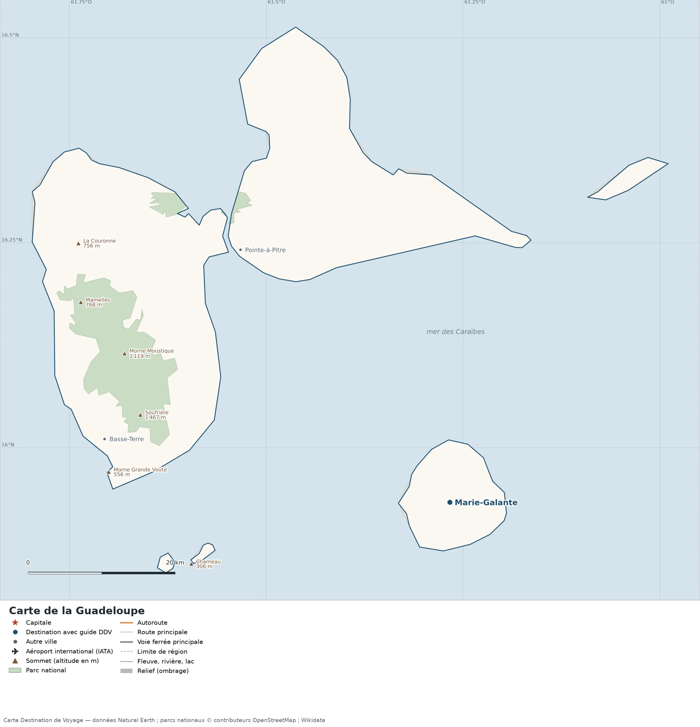
Open the full-size map (high resolution, zoomable)
Key: red star = capital; blue dot = destination covered by a Destination de Voyage guide; blue italic name = region or island with a guide; grey dot = other city; plane = international airport (IATA code); brown triangle = summit (elevation); green areas = national parks; thick orange line = expressway, light orange = main road; black-and-white line = main railway; grey dashes = regional boundaries; blue = rivers and lakes; shading = terrain; grid = latitude and longitude.
Sources: base map, cities, roads, railways, airports, administrative boundaries, rivers, lakes and terrain hillshading: Natural Earth 1:10m (public domain). National parks: © OpenStreetMap contributors (ODbL licence). Summits and elevations: Wikidata and Natural Earth. Places missing from Natural Earth: Wikipedia coordinates. Map produced by Destination de Voyage.
Regions and destinations on the map of Guadeloupe
| Region | Our guides | Other cities on the map |
|---|---|---|
| Guadeloupe | Marie-Galante | Pointe-à-Pitre, Basse-Terre |
Terrain, national parks and airports
Main summits (elevations from Wikidata / Natural Earth): Soufrière (1,467 m / 4,813 ft), Grand-Montagne (275 m / 902 ft).
National parks shown (1): Guadeloupe National Park (core zone).
Our guides by destination
How to read the map of Guadeloupe
- Extent: the mapped territory covers about 1,657 km² (640 sq mi), by Destination de Voyage calculation on the Natural Earth outline; Wikidata gives 1,628 km² (629 sq mi). It extends from 15.85° N to 16.51° N in latitude and from 61.80° W to 60.99° W in longitude, about 74 km (46 mi) from north to south and 86 km (53 mi) from west to east (bounding rectangle, outlying territories included).
- Outline: the perimeter of the territory on the map (coasts and land borders) is about 346 km (215 mi). The simplified Natural Earth outline smooths out small detours, so the real length of the coastline is greater. Destination de Voyage calculation.
- Time zone (IANA tz database 2026b): Pointe-à-Pitre:
America/Guadeloupe(UTC−4, all year). Difference from London and New York, and clock changes: Guadeloupe time difference. - Terrain: shading shows the relief and brown triangles mark the summits. The highest shown are Soufrière (1,467 m / 4,813 ft), Petit Sans Toucher (1,318 m / 4,324 ft), Matéliane (1,298 m / 4,259 ft), Morne Moustique (1,119 m / 3,671 ft), pitons de Bouillante (1,088 m / 3,570 ft). Wikidata gives La Soufrière (1,467 m / 4,813 ft) as the highest point.
- National parks (green areas): 1 whose centre lies inside the territory: Guadeloupe National Park (core zone). Outlines from OpenStreetMap or position from Wikidata.
Distances between the main cities (cross table)
Straight-line distances between the capital, our destinations and the largest cities on the map, with the direction from the first city. Roads or ferries always add distance.
| Route | Straight-line distance | Direction |
|---|---|---|
| Basse-Terre → Marie-Galante | 50 km (31 mi) | east |
| Basse-Terre → Pointe-à-Pitre | 35 km (22 mi) | northeast |
| Marie-Galante → Pointe-à-Pitre | 45 km (28 mi) | northwest |
Distances from Basse-Terre to the other 32 subdivisions
Subdivisions attached to the territory in Wikidata, ranked from nearest to farthest from Basse-Terre (straight-line distance to each subdivision’s reference point).
| Subdivision | Distance from Basse-Terre | Direction |
|---|---|---|
| Baillif | 3.1 km (1.9 mi) | northwest |
| Gourbeyre | 4.3 km (2.7 mi) | east |
| Saint-Claude | 5.0 km (3.1 mi) | northeast |
| Vieux-Fort | 6.5 km (4.0 mi) | southeast |
| Vieux-Habitants | 7.8 km (4.8 mi) | northwest |
| Trois-Rivières | 9.7 km (6.0 mi) | east |
| Bouillante | 16 km (10 mi) | north |
| Capesterre-Belle-Eau | 19 km (12 mi) | east |
| Terre-de-Bas | 19 km (12 mi) | southeast |
| Terre-de-Haut | 22 km (14 mi) | southeast |
| Goyave | 23 km (14 mi) | northeast |
| Petit-Bourg | 26 km (16 mi) | northeast |
| Pointe-Noire | 27 km (17 mi) | north |
| Lamentin | 32 km (20 mi) | north |
| Baie-Mahault | 34 km (21 mi) | northeast |
| Pointe-à-Pitre arrondissement | 34 km (21 mi) | northeast |
| Pointe-à-Pitre | 35 km (22 mi) | northeast |
| Le Gosier | 35 km (22 mi) | northeast |
| Deshaies | 35 km (22 mi) | north |
| Sainte-Rose | 38 km (24 mi) | north |
| Les Abymes | 39 km (24 mi) | northeast |
| Saint-Louis | 44 km (27 mi) | east |
| Sainte-Anne | 45 km (28 mi) | northeast |
| Grand-Bourg | 46 km (29 mi) | east |
| Morne-à-l’Eau | 47 km (29 mi) | northeast |
| Petit-Canal | 50 km (31 mi) | northeast |
| Port-Louis | 51 km (32 mi) | northeast |
| Le Moule | 56 km (35 mi) | northeast |
| Capesterre-de-Marie-Galante | 56 km (35 mi) | east |
| Saint-François | 57 km (35 mi) | northeast |
| Anse-Bertrand | 58 km (36 mi) | northeast |
| La Désirade | 78 km (48 mi) | northeast |
Neighbouring territories: distances from Basse-Terre
The nearest administrative centres and capitals to Basse-Terre, useful for planning a combined trip by air or boat. Country names are those used by Natural Earth.
| City | Territory (Natural Earth) | Straight-line distance | Direction |
|---|---|---|---|
| Roseau | Dominica | 86 km (53 mi) | southeast |
| Saint John’s | Antigua and Barbuda | 125 km (78 mi) | north |
| Fort-de-France | France | 169 km (105 mi) | southeast |
| Basseterre | Saint Kitts and Nevis | 179 km (111 mi) | northwest |
| Castries | Saint Lucia | 235 km (146 mi) | south |
| Kingstown | Saint Vincent and the Grenadines | 322 km (200 mi) | south |
| Bridgetown | Barbados | 394 km (245 mi) | southeast |
| Saint-Georges | Grenada | 439 km (273 mi) | south |
Sample itineraries for Guadeloupe based on the map
Our guide covers one destination on the map: Marie-Galante, 50 km (31 mi) east of Basse-Terre. Combine it with the capital and the cities in the distance table.
- Our complete guide to Guadeloupe: highlights, detailed itineraries and budget
- When to go to Guadeloupe: best time and month-by-month climate
- Time difference: Guadeloupe
Frequently asked questions
What is the highest summit shown on the map?
Soufrière, at an elevation of 1,467 m (4,813 ft) (source: Natural Earth).
What is the capital of Guadeloupe?
Basse-Terre (red star on the map), at 16.00° N, 61.73° W.
Where is Basse-Terre on the map of Guadeloupe?
At 16.00° N, 61.73° W, marked by the red star.
How many regions does Guadeloupe have?
Natural Earth does not divide this territory into several subdivisions on our base map. Wikidata lists 32 entities of type « French commune » attached directly to the territory; the official division may differ from the one on our map.
Where is Guadeloupe?
Continent: North America (Wikidata). Guadeloupe lies in the Northern Hemisphere, west of the Greenwich meridian (Basse-Terre taken as the reference point; Destination de Voyage calculation). Coasts: Caribbean Sea.
Where is Marie-Galante?
About 50 km (31 mi) east of Basse-Terre in a straight line (Destination de Voyage calculation). All our advice: Marie-Galante.
What is the area of Guadeloupe?
About 1,657 km² (640 sq mi) by our calculation on the Natural Earth outline; Wikidata gives 1,628 km² (629 sq mi). The differences come from the precision of the coastline and inland waters.
Our sources
- Natural Earth 1:10m (public domain): country and subdivision boundaries, cities, airports, rivers, lakes, terrain, at naturalearthdata.com.
- Wikidata, item Q17012 (Guadeloupe): area, highest point, continent and subdivisions, accessed 23 October 2026.
- © OpenStreetMap contributors (ODbL licence): national park outlines.
- Wikidata: position of national parks and elevation of summits.
- Wikipedia (French edition): coordinates of places missing from Natural Earth.
- Destination de Voyage calculations: distances (haversine, 6,371 km radius), directions and areas (WGS84 ellipsoid, pyproj library).
- Our methodology