
This map of Romania shows the capital, Bucharest, the destination covered in our guides and the main cities, with terrain, national parks, expressways, railways and rivers.
Neighbouring countries (land border): Bulgaria, Hungary, Moldova, Serbia and Ukraine. Its coasts face: Black Sea.

Our travel deals for Map
Affiliate links: we earn a commission, at no extra cost to you.
 FlightsKiwi.comCompare flights and airline combinations to Map.Compare flights

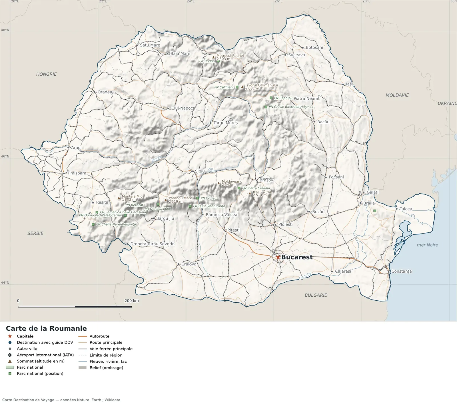
Open the full-size map (high resolution, zoomable)
Key: red star = capital; blue dot = destination covered by a Destination de Voyage guide; blue italic name = region or island with a guide; grey dot = other city; plane = international airport (IATA code); brown triangle = summit (elevation); green areas = national parks (green square = national park located by a point); thick orange line = expressway, light orange = main road; black-and-white line = main railway; grey dashes = regional boundaries; blue = rivers and lakes; shading = terrain; grid = latitude and longitude.
Sources: base map, cities, roads, railways, airports, administrative boundaries, rivers, lakes and hillshading: Natural Earth 1:10m (public domain). National parks: Wikidata. Summits and elevations: Wikidata and Natural Earth. Places missing from Natural Earth: Wikipedia coordinates. Map produced by Destination de Voyage.
Regions and destinations on the map of Romania
| Region | Our guides | Other cities on the map |
|---|---|---|
| Bucharest | Bucharest | — |
| Argeș | — | Pitești |
| Bacău | — | Bacău |
| Botoșani | — | Botoșani |
| Brașov | — | Brașov |
| Caraș-Severin | — | Reșița |
| Cluj | — | Cluj-Napoca |
| Constanța | — | Constanța |
| Dolj | — | Craiova |
| Iași | — | Iași |
| Maramureș | — | Baia Mare |
| Mureș | — | Târgu Mureș |
| Prahova | — | Ploiești |
| Timiș | — | Timișoara |
Straight-line distances between the main cities
Straight-line distances calculated from place coordinates (haversine formula). Actual journeys by road, rail, ferry or air are longer.
| Route | Straight-line distance |
|---|---|
| Bucharest – Iași | 325 km (202 mi) |
| Bucharest – Constanța | 202 km (126 mi) |
| Bucharest – Cluj-Napoca | 326 km (203 mi) |
| Bucharest – Timișoara | 410 km (255 mi) |
| Bucharest – Brașov | 140 km (87 mi) |
| Bucharest – Craiova | 181 km (112 mi) |
| Bucharest – Ploiești | 57 km (35 mi) |
| Bucharest – Bacău | 247 km (153 mi) |
Terrain, national parks and airports
Main summits (elevations from Wikidata / Natural Earth): Moldoveanu (2,543 m / 8,343 ft), Parângu Mare (2,519 m / 8,264 ft), Mount Omu (2,514 m / 8,248 ft), Peleaga (2,509 m / 8,232 ft), Netedu (2,351 m / 7,713 ft).
National parks shown (13): Buila-Vânturarița National Park, Ceahlău National Park, Cheile Bicazului-Hășmaș National Park, Cheile Nerei-Beuşniţa National Park, Cozia National Park, Călimani National Park, Defileul Jiului National Park, Domogled-Valea Cernei National Park, Piatra Craiului National Park, Retezat National Park, Rodna National Park, Semenic-Cheile Carașului National Park, Măcin Mountains National Park.
Our guides by destination
The 42 regions of Romania and what sets them apart
The Natural Earth base map divides Romania into 42 first-level subdivisions (type: Judet and Municipiu). These are the grey dashed boundaries on the map. The table ranks them from largest to smallest, with the cities, highest point and international airports the map places in each. Only the 22 largest are listed.
| Region | Type | Area | Cities and guides | Highest point shown | Airport |
|---|---|---|---|---|---|
| Timiș | Judet | 8,856 km² (3,419 sq mi) | Timișoara | — | — |
| Suceava | Judet | 8,836 km² (3,412 sq mi) | Suceava | Izvorul Călimanului (2,031 m / 6,663 ft) | — |
| Caraș-Severin | Judet | 8,399 km² (3,243 sq mi) | Reșița | Muntele Mic (1,802 m / 5,912 ft) | — |
| Arad | Judet | 7,815 km² (3,017 sq mi) | Arad | — | — |
| Tulcea | Judet | 7,679 km² (2,965 sq mi) | Tulcea | — | — |
| Bihor | Judet | 7,618 km² (2,941 sq mi) | Oradea | — | — |
| Constanța | Judet | 7,248 km² (2,798 sq mi) | Constanța | — | — |
| Dolj | Judet | 7,045 km² (2,720 sq mi) | Craiova | — | — |
| Hunedoara | Judet | 6,972 km² (2,692 sq mi) | Deva | Parângu Mare (2,519 m / 8,264 ft) | — |
| Bacău | Judet | 6,735 km² (2,600 sq mi) | Bacău | — | — |
| Argeș | Judet | 6,678 km² (2,578 sq mi) | Pitești | Moldoveanu (2,543 m / 8,343 ft) | — |
| Cluj | Judet | 6,640 km² (2,564 sq mi) | Cluj-Napoca | — | — |
| Harghita | Judet | 6,576 km² (2,539 sq mi) | Miercurea-Ciuc | Harghita Mădăraș (1,800 m / 5,906 ft) | — |
| Mureș | Judet | 6,544 km² (2,527 sq mi) | Târgu Mureș | — | — |
| Maramureș | Judet | 6,440 km² (2,486 sq mi) | Baia Mare | Pietrosul Rodnei (2,303 m / 7,556 ft) | — |
| Alba | Judet | 6,297 km² (2,431 sq mi) | Alba Iulia | Șurean (1,997 m / 6,552 ft) | — |
| Buzău | Judet | 5,988 km² (2,312 sq mi) | Buzău | Penteleu (1,772 m / 5,814 ft) | — |
| Teleorman | Judet | 5,885 km² (2,272 sq mi) | Alexandria | — | — |
| Vâlcea | Judet | 5,641 km² (2,178 sq mi) | Râmnicu Vâlcea | Netedu (2,351 m / 7,713 ft) | — |
| Neamț | Judet | 5,635 km² (2,176 sq mi) | Piatra Neamț | Murgoci (1,198 m / 3,930 ft) | — |
| Sibiu | Judet | 5,570 km² (2,151 sq mi) | Sibiu | Negoiu (2,535 m / 8,317 ft) | — |
| Gorj | Judet | 5,549 km² (2,142 sq mi) | Târgu Jiu | Parângu Mare (2,519 m / 8,264 ft) | — |
- Largest: Timiș, about 8,856 km² (3,419 sq mi), or 4% of the mapped territory.
- Smallest: Bucharest, about 285 km² (110 sq mi).
- Capital region: Bucharest is in the Bucharest subdivision.
- Highest region: Argeș, home to Moldoveanu (2,543 m / 8,343 ft), the highest summit shown on the map.
- Region best covered by our guides: Bucharest (Bucharest).
How to read the map of Romania
- Extent: the mapped territory covers about 236,377 km² (91,266 sq mi), calculated by Destination de Voyage on the Natural Earth outline; Wikidata gives 238,397 km² (92,046 sq mi). It spans 43.65° N to 48.27° N in latitude and 20.24° E to 29.70° E in longitude, about 514 km (319 mi) north to south and 731 km (454 mi) west to east (bounding rectangle, including distant territories).
- Outline: the perimeter of the territory on the map (coasts and land borders) is about 2,813 km (1,748 mi). The simplified Natural Earth outline smooths out small detours: the real length of the coastline is greater. Destination de Voyage calculation.
- Time zone (IANA tz database 2026b): Bucharest:
Europe/Bucharest(UTC+2 in January, UTC+3 in July). Time difference and clock changes: time difference in Romania. - Terrain: shading shows the terrain and brown triangles mark the summits. The highest shown are Moldoveanu (2,543 m / 8,343 ft), Negoiu (2,535 m / 8,317 ft), Parângu Mare (2,519 m / 8,264 ft), Mount Omu (2,514 m / 8,248 ft), Peleaga (2,509 m / 8,232 ft). Wikidata gives Moldoveanu (2,544 m / 8,346 ft) as the highest point.
- Rivers (blue lines): Danube (about 724 km / 450 mi within the territory), Olt (about 525 km / 326 mi within the territory), Mureș (about 507 km / 315 mi within the territory), Prut (about 354 km / 220 mi within the territory), Ialomița (about 268 km / 167 mi within the territory), Borcea (about 104 km / 65 mi within the territory). Lengths measured on the simplified Natural Earth outline: Destination de Voyage calculation.
- National parks (green areas): 13 whose centre lies within the territory, including Buila-Vânturarița National Park, Ceahlău National Park, Cheile Bicazului-Hășmaș National Park, Cheile Nerei-Beuşniţa National Park, Cozia National Park and Călimani National Park. Outlines from OpenStreetMap or position from Wikidata.
Distances between the main cities (cross table)
Straight-line distances between the capital, our destinations and the largest cities on the map, with the direction from the first city. Road or ferry routes always add distance.
| Route | Straight-line distance | Direction |
|---|---|---|
| Bucharest → Iași | 325 km (202 mi) | north |
| Bucharest → Cluj-Napoca | 326 km (203 mi) | north-west |
| Bucharest → Timișoara | 410 km (255 mi) | north-west |
| Bucharest → Galați | 191 km (119 mi) | north-east |
| Bucharest → Brașov | 140 km (87 mi) | north |
| Bucharest → Craiova | 181 km (112 mi) | west |
| Iași → Cluj-Napoca | 305 km (190 mi) | west |
| Iași → Timișoara | 511 km (318 mi) | west |
| Iași → Galați | 194 km (121 mi) | south |
| Iași → Brașov | 227 km (141 mi) | south-west |
| Iași → Craiova | 429 km (267 mi) | south-west |
| Cluj-Napoca → Timișoara | 215 km (134 mi) | south-west |
| Cluj-Napoca → Galați | 373 km (232 mi) | east |
| Cluj-Napoca → Brașov | 200 km (124 mi) | south-east |
| Cluj-Napoca → Craiova | 274 km (170 mi) | south |
| Timișoara → Galați | 532 km (331 mi) | east |
| Timișoara → Brașov | 341 km (212 mi) | east |
| Timișoara → Craiova | 259 km (161 mi) | south-east |
Typical itineraries in Romania from the map
Our guide covers one destination on the map: Bucharest. Combine it with the capital and the cities in the distance table.
- Our complete guide to Romania: must-sees, detailed itineraries and budget
- When to go to Romania: best time to visit and month-by-month climate
- Time difference in Romania: what time is it?
- For a trip combined with a neighbouring country: map of Bulgaria and map of Hungary.
Frequently asked questions
What is the capital of Romania?
Bucharest, marked by the red star on the map.
Which countries border Romania?
Countries sharing a land border: Bulgaria, Hungary, Moldova, Serbia and Ukraine.
What is the highest summit shown on the map?
Moldoveanu, at an elevation of 2,543 m / 8,343 ft (source: Natural Earth).
Where is Bucharest on the map of Romania?
At 44.44° N and 26.10° E, marked by the red star, in the Bucharest subdivision.
How many regions does Romania have?
Our map, based on Natural Earth, shows 42 first-level subdivisions (Judet and Municipiu). Wikidata lists 41 entities of the type “județ of Romania” attached directly to the territory; the official division may differ from the map’s.
Where is Romania?
Continent: Europe (Wikidata). Romania lies in the northern hemisphere, east of the Greenwich meridian. Coasts: Black Sea. Land borders: Bulgaria, Hungary, Moldova, Serbia and Ukraine.
What is the area of Romania?
About 236,377 km² (91,266 sq mi) by our calculation on the Natural Earth outline; Wikidata gives 238,397 km² (92,046 sq mi). Differences come from the precision of the coastline and inland waters.
Our sources
- Natural Earth 1:10m (public domain): country and subdivision boundaries, cities, airports, rivers, lakes, terrain, on naturalearthdata.com.
- Wikidata, item Q218 (Romania): area, highest point, continent and subdivisions, accessed 23 October 2026.
- Wikidata: national park positions and summit elevations.
- Wikipedia (French edition): coordinates of places missing from Natural Earth.
- Destination de Voyage calculations: distances (haversine, radius 6,371 km), directions and areas (WGS84 ellipsoid, pyproj library).
- Our methodology