
This map of Scotland shows the 2 destinations covered in our guides and the main cities, with terrain, expressways, railways, rivers and international airports.
Neighbouring countries (land border): England. Its coasts border the Irish Sea, the Norwegian Sea, the Sea of the Hebrides, the North Sea and the Atlantic Ocean. Remote territories (Shetland) appear in insets, each with its own scale.

Our travel deals for Map
Affiliate links: we earn a commission, at no extra cost to you.
 FlightsKiwi.comCompare flights and airline combinations to Map.Compare flights
- eSIMAiraloData plan to install before you leave (eSIM-compatible phone).See plans


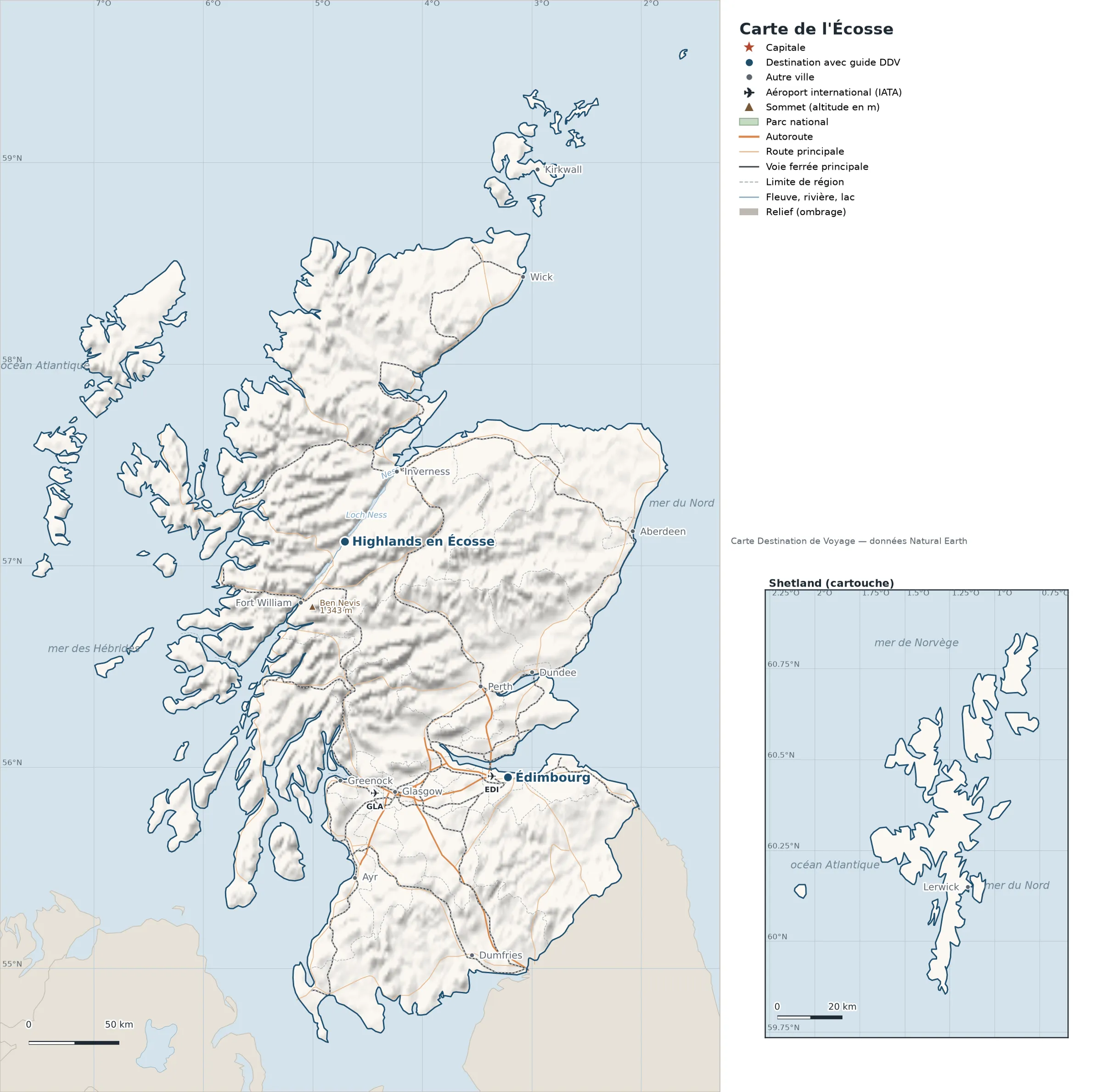
Open the full-size map (high resolution, zoomable)
Key: red star = capital; blue dot = destination covered by a Destination de Voyage guide; blue italic name = region or island with a guide; grey dot = other city; plane = international airport (IATA code); brown triangle = summit (elevation); green areas = national parks; thick orange line = expressway, light orange = main road; black-and-white line = main railway; grey dashes = regional boundaries; blue = rivers and lakes; shading = terrain; grid = latitude and longitude.
Sources: base map, cities, roads, railways, airports, administrative boundaries, rivers, lakes and hillshading: Natural Earth 1:10m (public domain). Summits and elevations: Wikidata and Natural Earth. Places missing from Natural Earth: Wikipedia coordinates. Map produced by Destination de Voyage.
Regions and destinations on the map of Scotland
| Region | Our guides | Other cities on the map |
|---|---|---|
| Highland | Highlands | Wick, Inverness, Fort William |
| Edinburgh | Edinburgh | — |
| Aberdeen | — | Aberdeen |
| Dumfries and Galloway | — | Dumfries |
| Dundee | — | Dundee |
| Glasgow | — | Glasgow |
| Inverclyde | — | Greenock |
| Orkney | — | Kirkwall |
| Perth and Kinross | — | Perth |
| Shetland | — | Lerwick |
| South Ayrshire | — | Ayr |
Straight-line distances between the main cities
Straight-line distances calculated from place coordinates (haversine formula). Actual journeys by road, rail, boat or plane are longer.
| Route | Straight-line distance |
|---|---|
| Highlands – Edinburgh | 159 km (99 mi) |
Terrain, national parks and airports
Main summits (elevations from Wikidata / Natural Earth): Ben Nevis (1,343 m / 4,406 ft).
International airports shown: EDI (Edinburgh), GLA (Glasgow).
Our guides by destination
The 32 regions of Scotland and what sets them apart
The Natural Earth base map divides Scotland into 32 first-level subdivisions (type: Island Area, Unitary District and Unitary District (city)). These are the grey dashed boundaries on the map. The table ranks them from largest to smallest, with the cities, highest point and international airports the map places in each. Only the 22 largest are listed.
| Region | Type | Area | Cities and guides | Highest point shown | Airport |
|---|---|---|---|---|---|
| Highland | Unitary District | 25,810 km² (9,965 sq mi) | Highlands, Wick, Inverness, Fort William | Ben Nevis (1,343 m / 4,406 ft) | — |
| Argyll and Bute | Unitary District | 7,591 km² (2,931 sq mi) | — | — | — |
| Dumfries and Galloway | Unitary District | 6,405 km² (2,473 sq mi) | Dumfries | — | — |
| Aberdeenshire | Unitary District | 6,343 km² (2,449 sq mi) | — | — | — |
| Perth and Kinross | Unitary District | 5,434 km² (2,098 sq mi) | Perth | — | — |
| Scottish Borders | Unitary District | 4,670 km² (1,803 sq mi) | — | — | — |
| Outer Hebrides | Island Area | 2,891 km² (1,116 sq mi) | — | — | — |
| Stirling | Unitary District | 2,288 km² (883 sq mi) | — | — | — |
| Moray | Unitary District | 2,235 km² (863 sq mi) | — | — | — |
| Angus | Unitary District | 2,116 km² (817 sq mi) | — | — | — |
| South Lanarkshire | Unitary District | 1,751 km² (676 sq mi) | — | — | — |
| Shetland | Unitary District (city) | 1,362 km² (526 sq mi) | Lerwick | — | — |
| Fife | Unitary District | 1,323 km² (511 sq mi) | — | — | — |
| East Ayrshire | Unitary District | 1,284 km² (496 sq mi) | — | — | — |
| South Ayrshire | Unitary District | 1,258 km² (486 sq mi) | Ayr | — | — |
| Orkney | Unitary District | 935 km² (361 sq mi) | Kirkwall | — | — |
| East Lothian | Unitary District | 734 km² (283 sq mi) | — | — | — |
| North Lanarkshire | Unitary District | 480 km² (185 sq mi) | — | — | — |
| North Ayrshire | Unitary District | 469 km² (181 sq mi) | — | — | — |
| West Lothian | Unitary District | 417 km² (161 sq mi) | — | — | — |
| Midlothian | Unitary District | 345 km² (133 sq mi) | — | — | — |
| Edinburgh | Unitary District (city) | 291 km² (112 sq mi) | Edinburgh | — | EDI |
- Largest: Highland, about 25,810 km² (9,965 sq mi), or 33% of the mapped territory.
- Smallest: Dundee, about 83 km² (32 sq mi).
- Highest region: Highland, home to Ben Nevis (1,343 m / 4,406 ft), the highest summit shown on the map.
- Region best covered by our guides: Highland (Highlands).
- Air access: the international airports on the map are spread across 2 of 32 regions (Edinburgh and Renfrewshire).
How to read the map of Scotland
- Extent: the mapped territory covers about 78,302 km² (30,233 sq mi), according to our calculation on the Natural Earth outline; Wikidata gives 78,782 km² (30,418 sq mi). It extends from 54.63° N to 60.85° N in latitude and from 13.69° W to 0.75° W in longitude, about 691 km (429 mi) from north to south and 767 km (477 mi) from west to east (bounding rectangle, including remote territories).
- Outline: the perimeter of the territory on the map (coasts and land borders) is about 7,401 km (4,599 mi). The simplified Natural Earth outline smooths out small detours: the actual length of the coastline is greater. Destination de Voyage calculation.
- Time zone (IANA tz database 2026b): Edinburgh:
Europe/London(UTC+0 in January, UTC+1 in July). - Terrain: shading shows the relief and brown triangles mark the summits. The highest shown are Ben Nevis (1,343 m / 4,406 ft). Wikidata gives Ben Nevis (1,345 m / 4,413 ft) as the highest point.
- Rivers (blue lines): Ness, about 49 km (30 mi) traced within the territory; Oich, about 19 km (12 mi) traced within the territory; Caledonian Canal, about 15 km (9.3 mi) traced within the territory; Loch Oich, about 12 km (7.5 mi) traced within the territory. Lengths measured on the simplified Natural Earth outline: Destination de Voyage calculation.
- Lakes named in Natural Earth: Loch Ness and Loch Lochy.
- International airports (plane icon): EDI (Edinburgh, about 9.0 km (5.6 mi) from the centre of Edinburgh); GLA (Glasgow, about 11 km (6.8 mi) from the centre of Glasgow). Straight-line distances: Destination de Voyage calculation.
Distances between the main cities (cross table)
Straight-line distances between the capital, our destinations and the largest cities on the map, with the direction from the first city. Roads and ferries always add distance.
| Route | Straight-line distance | Direction |
|---|---|---|
| Highlands → Edinburgh | 159 km (99 mi) | southeast |
| Highlands → Glasgow | 141 km (88 mi) | south |
| Highlands → Aberdeen | 159 km (99 mi) | east |
| Highlands → Dundee | 127 km (79 mi) | southeast |
| Highlands → Greenock | 132 km (82 mi) | south |
| Highlands → Ayr | 186 km (116 mi) | south |
| Edinburgh → Glasgow | 65 km (40 mi) | west |
| Edinburgh → Aberdeen | 153 km (95 mi) | northeast |
| Edinburgh → Dundee | 60 km (37 mi) | north |
| Edinburgh → Greenock | 95 km (59 mi) | west |
| Edinburgh → Ayr | 104 km (65 mi) | southwest |
| Glasgow → Aberdeen | 196 km (122 mi) | northeast |
| Glasgow → Dundee | 102 km (63 mi) | northeast |
| Glasgow → Greenock | 32 km (20 mi) | west |
| Glasgow → Ayr | 53 km (33 mi) | southwest |
| Aberdeen → Dundee | 96 km (60 mi) | southwest |
| Aberdeen → Greenock | 214 km (133 mi) | southwest |
| Aberdeen → Ayr | 247 km (153 mi) | southwest |
Typical itineraries in Scotland based on the map
To link our 2 destinations without backtracking, here is the shortest order step by step, starting from the first point (nearest-neighbour method, straight-line distances): Highlands → Edinburgh (159 km / 99 mi). Total: about 159 km (99 mi) in a straight line. Adjust for flights, ferries and the season.
- Our complete guide to Scotland: must-sees, detailed itineraries and budget
- When to go to Scotland: best time to visit and month-by-month climate
Frequently asked questions
Which countries border Scotland?
Countries sharing a land border: England.
What is the highest summit shown on the map?
Ben Nevis, at 1,343 m (4,406 ft) elevation (source: Natural Earth).
Which international airports are on the map?
EDI (Edinburgh), GLA (Glasgow).
Why are some islands shown in an inset?
They are too far from the main territory to fit on the same scale: Shetland is shown separately, with its own scale.
How many regions does Scotland have?
Our map, based on Natural Earth, shows 32 first-level subdivisions (Island Area, Unitary District and Unitary District (city)). Wikidata lists 32 entities of type “council area of Scotland” attached directly to the territory; the official division may differ from the one on the map.
Where is Scotland?
Continent: Europe (Wikidata). Scotland lies in the northern hemisphere, west of the Greenwich meridian. Coasts: the Irish Sea, the Norwegian Sea, the Sea of the Hebrides, the North Sea and the Atlantic Ocean. Land borders: England.
What is the area of Scotland?
About 78,302 km² (30,233 sq mi) according to our calculation on the Natural Earth outline; Wikidata gives 78,782 km² (30,418 sq mi). Differences come from the precision of the coastline and inland waters.
Our sources
- Natural Earth 1:10m (public domain): country and subdivision boundaries, cities, airports, rivers, lakes, terrain, at naturalearthdata.com.
- Wikidata, item Q22 (Scotland): area, highest point, continent and subdivisions, accessed 23 October 2026.
- Wikipedia: coordinates of places missing from Natural Earth.
- Destination de Voyage calculations: distances (haversine, radius 6,371 km), directions and areas (WGS84 ellipsoid, pyproj library).
- Our methodology