
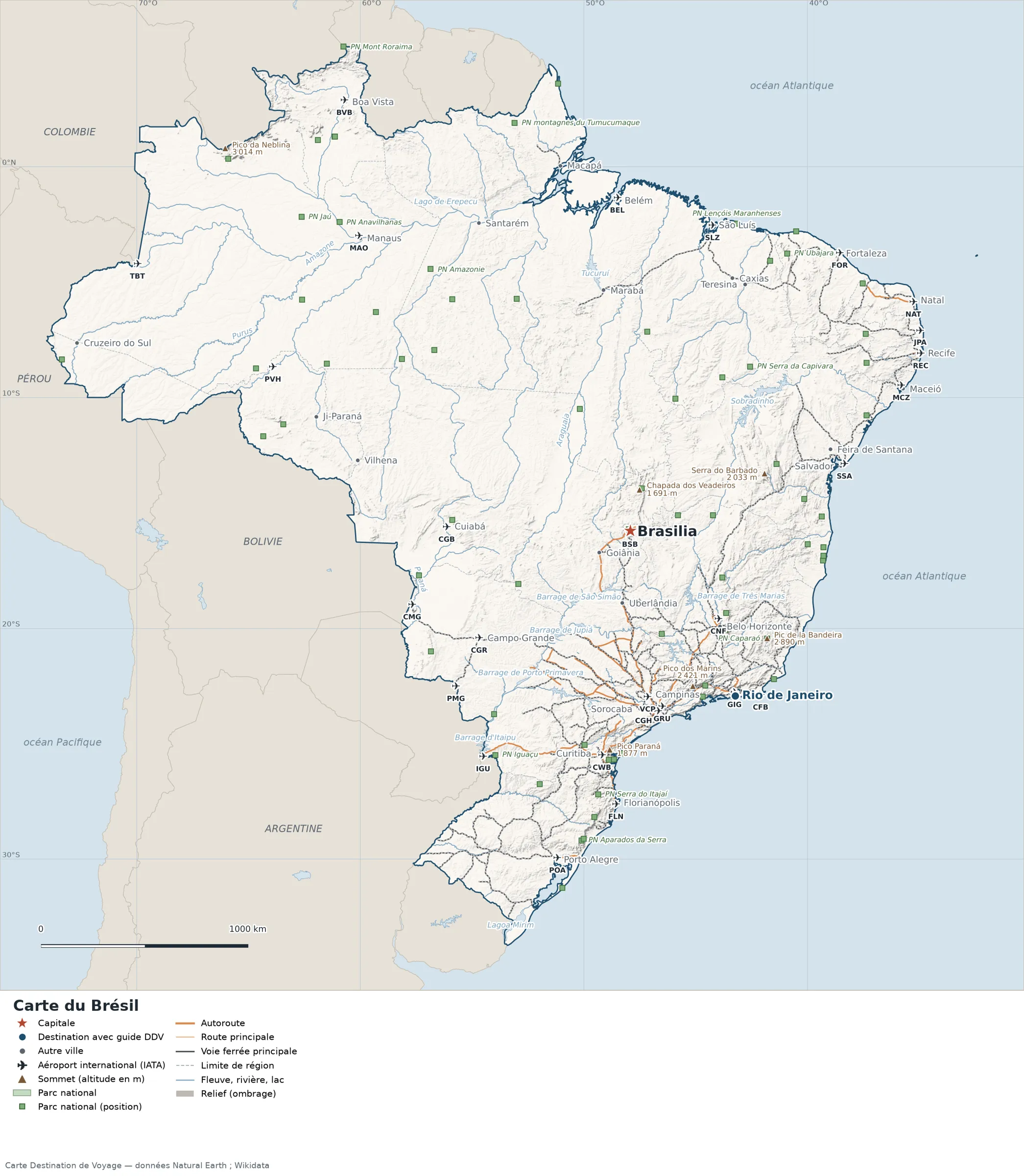
This map of Brazil shows the capital, Brasília, the destination covered in our guides and the main cities, with terrain, national parks, expressways, railways, rivers and international airports.
Neighbouring countries (land border): Argentina, Bolivia, Colombia, France (French Guiana), Guyana, Paraguay, Peru, Suriname, Uruguay and Venezuela. Its coasts face: Amazon, Baía de Marajó, Baía de São Marcos, Canal Perigoso, Canal do Norte and Canal do Sul.

Our travel deals for Map
Affiliate links: we earn a commission, at no extra cost to you.
 FlightsKiwi.comCompare flights and airline combinations to Map.Compare flights
- eSIMSailyAnother eSIM plan to compare: data, validity, network.See Saily plans


Open the full-size map (high resolution, zoomable)
Key: red star = capital ; blue dot = destination covered by a Destination de Voyage guide ; blue italic name = region or island with a guide ; grey dot = other city ; plane = international airport (IATA code) ; brown triangle = summit (elevation) ; green areas = national parks (green square = national park located by a point) ; thick orange line = expressway, light orange = main road ; black-and-white line = main railway ; grey dashes = regional boundaries ; blue = rivers and lakes ; shading = terrain ; grid = latitude and longitude.
Sources: base map, cities, roads, railways, airports, administrative boundaries, rivers, lakes and hillshading: Natural Earth 1:10m (public domain). National parks: Wikidata. Summits and elevations: Wikidata and Natural Earth. Places missing from Natural Earth: Wikipedia coordinates. Map produced by Destination de Voyage.
Regions and destinations on the map of Brazil
| Region | Our guides | Other cities on the map |
|---|---|---|
| Rio de Janeiro | Rio de Janeiro | — |
| Amapá | — | Macapá |
| Amazonas | — | Manaus |
| Bahia | — | Salvador |
| Ceará | — | Fortaleza |
| Goiás | — | Goiânia |
| Mato Grosso do Sul | — | Campo Grande |
| Paraná | — | Curitiba |
| Pará | — | Belém |
| Pernambuco | — | Recife |
| Rio Grande do Sul | — | Porto Alegre |
| Santa Catarina | — | Florianópolis |
| São Paulo | — | São Paulo |
| Federal District | — | Brasília |
Straight-line distances between the main cities
Straight-line distances calculated from place coordinates (haversine formula). Actual journeys by road, rail, boat or plane are longer.
| Route | Straight-line distance |
|---|---|
| Brasília – Rio de Janeiro | 934 km (580 mi) |
| Brasília – São Paulo | 875 km (544 mi) |
| Brasília – Porto Alegre | 1,621 km (1,007 mi) |
| Brasília – Recife | 1,653 km (1,027 mi) |
| Brasília – Fortaleza | 1,683 km (1,046 mi) |
| Brasília – Salvador | 1,063 km (661 mi) |
| Brasília – Curitiba | 1,081 km (672 mi) |
| Brasília – Belém | 1,595 km (991 mi) |
Terrain, national parks and airports
Main summits (elevations from Wikidata / Natural Earth): Pico da Neblina (3,014 m / 9,888 ft), Serra Imeri (2,994 m / 9,823 ft), Pico da Bandeira (2,890 m / 9,482 ft), Pedra da Mina (2,798 m / 9,180 ft), Pico Maior de Friburgo (2,366 m / 7,762 ft).
National parks shown (69): the largest are labelled directly on the map.
International airports shown: CGB (Marechal Rondon), FLN (Hercilio Luz), JPA (Presidente Castro Pinto), NAT (Augusto Severo), SLZ (Marechal Cunha Machado), VCP (Viracopos-Campinas), MCZ (Maceio/Zumbi dos Palmares), PMG (Ponta Porã), CFB (Cabo Frio), TBT (Tabatinga), BVB (Boa Vista), CMG (Corumbá), IGU (Foz do Iguaçu), PVH (Gov. Jorge Teixeira de Oliveira), CNF (Tancredo Neves), BEL (Val de Caes), CGR (Campo Grande), CWB (Afonso Pena), FOR (Pinto Martins), GRU (São Paulo-Guarulhos), POA (Salgado Filho), REC (Gilberto Freyre), SSA (Deputado Luis Eduardo Magalhaes), MAO (Eduardo Gomes), BSB (Juscelino Kubitschek), CGH (Congonhas), GIG (Rio de Janeiro-Antonio Carlos Jobim).
Our Brazil guides by destination
Frequently asked questions
What is the capital of Brazil?
Brasília, marked by the red star on the map.
Which of our guide destinations is farthest from Brasília?
Rio de Janeiro, about 934 km (580 mi) in a straight line (Destination de Voyage calculation).
Which countries border Brazil?
Countries sharing a land border: Argentina, Bolivia, Colombia, France (French Guiana), Guyana, Paraguay, Peru, Suriname, Uruguay and Venezuela.
What is the highest summit shown on the map?
Pico da Neblina, at an elevation of 3,014 m (9,888 ft) (source: Natural Earth).
Which international airports are on the map?
CGB (Marechal Rondon), FLN (Hercilio Luz), JPA (Presidente Castro Pinto), NAT (Augusto Severo), SLZ (Marechal Cunha Machado), VCP (Viracopos-Campinas), MCZ (Maceio/Zumbi dos Palmares), PMG (Ponta Porã), CFB (Cabo Frio), TBT (Tabatinga), BVB (Boa Vista), CMG (Corumbá), IGU (Foz do Iguaçu), PVH (Gov. Jorge Teixeira de Oliveira), CNF (Tancredo Neves), BEL (Val de Caes), CGR (Campo Grande), CWB (Afonso Pena), FOR (Pinto Martins), GRU (São Paulo-Guarulhos), POA (Salgado Filho), REC (Gilberto Freyre), SSA (Deputado Luis Eduardo Magalhaes), MAO (Eduardo Gomes), BSB (Juscelino Kubitschek), CGH (Congonhas), GIG (Rio de Janeiro-Antonio Carlos Jobim).