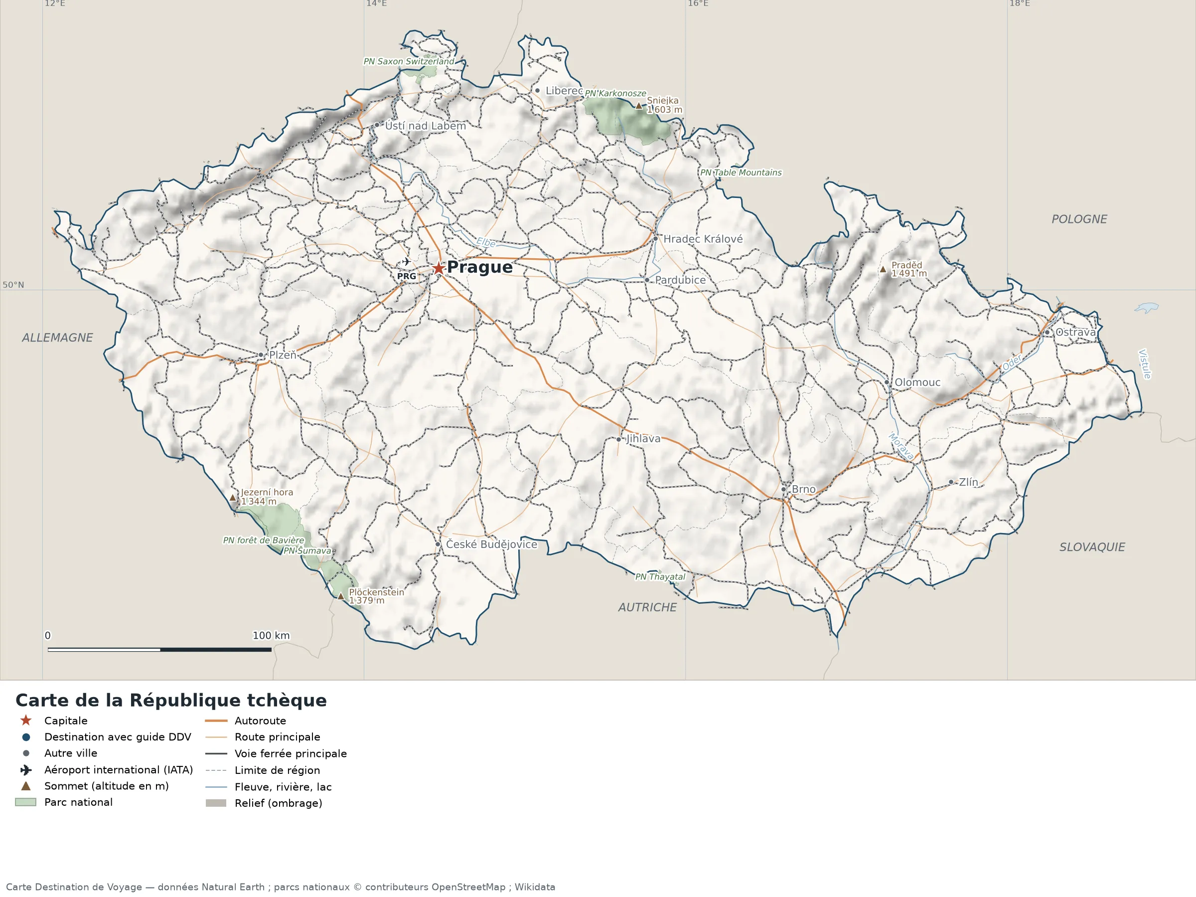
This map of the Czech Republic shows the capital, Prague, the destination covered in our guides and the main cities, with terrain, national parks, expressways, railways, rivers and international airports.
Neighbouring countries (land border): Germany, Austria, Poland and Slovakia.

Our travel deals for Map
Affiliate links: we earn a commission, at no extra cost to you.
 FlightsKiwi.comCompare flights and airline combinations to Map.Compare flights

Open the full-size map (high resolution, zoomable)
Key: red star = capital; blue dot = destination covered by a Destination de Voyage guide; blue italic name = region or island with a guide; grey dot = other city; plane = international airport (IATA code); brown triangle = summit (elevation); green areas = national parks; thick orange line = expressway, light orange = main road; black-and-white line = main railway; grey dashes = regional boundaries; blue = rivers and lakes; shading = terrain; grid = latitude and longitude.
Sources: base map, cities, roads, railways, airports, administrative boundaries, rivers, lakes and hillshading: Natural Earth 1:10m (public domain). National parks: © OpenStreetMap contributors (ODbL licence). Summits and elevations: Wikidata and Natural Earth. Places missing from Natural Earth: Wikipedia coordinates. Map produced by Destination de Voyage.
Regions and destinations on the map of the Czech Republic
| Region | Our guides | Other cities on the map |
|---|---|---|
| Prague | Prague | — |
| South Bohemia | — | České Budějovice |
| Hradec Králové | — | Hradec Králové |
| Liberec | — | Liberec |
| South Moravia | — | Brno |
| Moravia-Silesia | — | Ostrava |
| Olomouc | — | Olomouc |
| Pardubice | — | Pardubice |
| Plzeň-město | — | Plzeň |
| Vysočina | — | Jihlava |
| Zlín | — | Zlín |
| Ústí nad Labem Region | — | Ústí nad Labem |
Straight-line distances between the main cities
Straight-line distances calculated from place coordinates (haversine formula). Actual journeys by road, rail, ferry or air are longer.
| Route | Straight-line distance |
|---|---|
| Prague – Ostrava | 272 km (169 mi) |
| Prague – Brno | 183 km (114 mi) |
| Prague – Plzeň | 88 km (55 mi) |
| Prague – Zlín | 248 km (154 mi) |
| Prague – Pardubice | 93 km (58 mi) |
| Prague – Jihlava | 111 km (69 mi) |
| Prague – Liberec | 91 km (57 mi) |
| Prague – Olomouc | 206 km (128 mi) |
Terrain, national parks and airports
Main summits (elevations from Wikidata / Natural Earth): Sniejka (1,603 m / 5,259 ft), Praděd (1,491 m / 4,892 ft), Plöckenstein (1,379 m / 4,524 ft), Plattenhausenriegel (1,376 m / 4,514 ft).
National parks shown (8): Karkonosze National Park, Nationalpark Thayatal, Bohemian Switzerland National Park, Bavarian Forest National Park, Šumava National Park, Giant Mountains National Park, Saxon Switzerland National Park, Table Mountains National Park.
International airports shown: PRG (Ruzyn).
Our guides by destination
The 14 regions of the Czech Republic and what sets them apart
The Natural Earth base map divides the Czech Republic into 14 first-level subdivisions (type: Kraj). These are the grey dashed boundaries on the map. The table ranks them from largest to smallest, with the cities, highest point and international airports the map places in each.
| Region | Type | Area | Cities and guides | Highest point shown | Airport |
|---|---|---|---|---|---|
| Central Bohemia | Kraj | 10,906 km² (4,211 sq mi) | — | — | PRG |
| South Bohemia | Kraj | 9,980 km² (3,853 sq mi) | České Budějovice | Plöckenstein (1,379 m / 4,524 ft) | — |
| Plzeň-město | Kraj | 7,856 km² (3,033 sq mi) | Plzeň | Plattenhausenriegel (1,376 m / 4,514 ft) | — |
| South Moravia | Kraj | 7,091 km² (2,738 sq mi) | Brno | — | — |
| Vysočina | Kraj | 6,958 km² (2,686 sq mi) | Jihlava | — | — |
| Moravia-Silesia | Kraj | 5,618 km² (2,169 sq mi) | Ostrava | Praděd (1,491 m / 4,892 ft) | — |
| Ústí nad Labem Region | Kraj | 5,317 km² (2,053 sq mi) | Ústí nad Labem | — | — |
| Olomouc | Kraj | 4,955 km² (1,913 sq mi) | Olomouc | Keprník (1,423 m / 4,669 ft) | — |
| Hradec Králové | Kraj | 4,760 km² (1,838 sq mi) | Hradec Králové | Sniejka (1,603 m / 5,259 ft) | — |
| Pardubice | Kraj | 4,385 km² (1,693 sq mi) | Pardubice | — | — |
| Zlín | Kraj | 3,932 km² (1,518 sq mi) | Zlín | — | — |
| Karlovy Vary | Kraj | 3,285 km² (1,268 sq mi) | — | — | — |
| Liberec | Kraj | 3,198 km² (1,235 sq mi) | Liberec | Kotel (1,435 m / 4,708 ft) | — |
| Prague (capital) | Kraj | 517 km² (200 sq mi) | Prague | — | PRG |
- Largest: Central Bohemia, about 10,906 km² (4,211 sq mi), or 14% of the mapped territory.
- Smallest: Prague, about 517 km² (200 sq mi).
- Capital region: Prague is in the Prague subdivision.
- Highest region: Hradec Králové, home to Sniejka (1,603 m / 5,259 ft), the highest summit shown on the map.
- Region best covered by our guides: Prague (Prague).
- Air access: the international airports on the map are spread across 2 of the 14 regions (Central Bohemia and Prague).
How to read the map of the Czech Republic
- Extent: the mapped territory covers about 78,759 km² (30,409 sq mi), calculated by Destination de Voyage on the Natural Earth outline; Wikidata gives 78,871 km² (30,452 sq mi). It spans 48.56° N to 51.04° N in latitude and 12.08° E to 18.84° E in longitude, about 276 km (171 mi) north to south and 485 km (301 mi) west to east (bounding rectangle, including distant territories).
- Outline: the perimeter of the territory on the map (land borders) is about 1,729 km (1,074 mi). The simplified Natural Earth outline smooths out small detours: the real length of the borders is greater. Destination de Voyage calculation.
- Time zone (IANA tz database 2026b): Prague:
Europe/Prague(UTC+1 in January, UTC+2 in July). - Terrain: shading shows the terrain and brown triangles mark the summits. The highest shown are Sniejka (1,603 m / 5,259 ft), Wielki Szyszak (1,510 m / 4,954 ft), Vysoká pláň (1,497 m / 4,911 ft), Praděd (1,491 m / 4,892 ft), Łabski Szczyt (1,472 m / 4,829 ft). Wikidata gives Sniejka (1,603 m / 5,259 ft) as the highest point.
- Rivers (blue lines): Vltava (about 328 km / 204 mi within the territory), Elbe (about 315 km / 196 mi within the territory), Morava (about 224 km / 139 mi within the territory), Oder (about 77 km / 48 mi within the territory). Lengths measured on the simplified Natural Earth outline: Destination de Voyage calculation.
- National parks (green areas): 6 whose centre lies within the territory, including Karkonosze National Park, Nationalpark Thayatal, Bohemian Switzerland National Park, Bavarian Forest National Park, Šumava National Park and Giant Mountains National Park. Outlines from OpenStreetMap or position from Wikidata.
- International airports (plane icon): PRG (Ruzyn, about 14 km / 9 mi from the centre of Prague). Straight-line distances: Destination de Voyage calculation.
Distances between the main cities (cross table)
Straight-line distances between the capital, our destinations and the largest cities on the map, with the direction from the first city. Road or ferry routes always add distance.
| Route | Straight-line distance | Direction |
|---|---|---|
| Prague → Ostrava | 272 km (169 mi) | east |
| Prague → Brno | 183 km (114 mi) | south-east |
| Prague → Plzeň | 88 km (55 mi) | south-west |
| Prague → Zlín | 248 km (154 mi) | east |
| Prague → Pardubice | 93 km (58 mi) | east |
| Prague → Liberec | 91 km (57 mi) | north-east |
| Ostrava → Brno | 138 km (86 mi) | south-west |
| Ostrava → Plzeň | 351 km (218 mi) | west |
| Ostrava → Zlín | 80 km (50 mi) | south-west |
| Ostrava → Pardubice | 180 km (112 mi) | west |
| Ostrava → Liberec | 250 km (155 mi) | north-west |
| Brno → Plzeň | 242 km (150 mi) | west |
| Brno → Zlín | 76 km (47 mi) | east |
| Brno → Pardubice | 112 km (70 mi) | north-west |
| Brno → Liberec | 209 km (130 mi) | north-west |
| Plzeň → Zlín | 315 km (196 mi) | east |
| Plzeň → Pardubice | 175 km (109 mi) | east |
| Plzeň → Liberec | 170 km (106 mi) | north-east |
Typical itineraries in the Czech Republic from the map
Our guide covers one destination on the map: Prague. Combine it with the capital and the cities in the distance table.
- Our complete guide to the Czech Republic: must-sees, detailed itineraries and budget
- When to go to the Czech Republic: best time to visit and month-by-month climate
- For a trip combined with a neighbouring country: map of Germany, map of Austria and map of Poland.
Frequently asked questions
What is the capital of the Czech Republic?
Prague, marked by the red star on the map.
Which countries border the Czech Republic?
Countries sharing a land border: Germany, Austria, Poland and Slovakia.
What is the highest summit shown on the map?
Sniejka, at an elevation of 1,603 m / 5,259 ft (source: Natural Earth).
Which international airports are on the map?
PRG (Ruzyn).
Where is Prague on the map of the Czech Republic?
At 50.09° N and 14.46° E, marked by the red star, in the Prague subdivision.
How many regions does the Czech Republic have?
Our map, based on Natural Earth, shows 14 first-level subdivisions (Kraj). Wikidata lists 14 entities of the type “kraj of the Czech Republic” attached directly to the territory; the official division may differ from the map’s.
Where is the Czech Republic?
Continent: Europe (Wikidata). The Czech Republic lies in the northern hemisphere, east of the Greenwich meridian. Land borders: Germany, Austria, Poland and Slovakia.
What is the area of the Czech Republic?
About 78,759 km² (30,409 sq mi) by our calculation on the Natural Earth outline; Wikidata gives 78,871 km² (30,452 sq mi). Differences come from the precision of the coastline and inland waters.
Our sources
- Natural Earth 1:10m (public domain): country and subdivision boundaries, cities, airports, rivers, lakes, terrain, on naturalearthdata.com.
- Wikidata, item Q213 (Czech Republic): area, highest point, continent and subdivisions, accessed 23 October 2026.
- © OpenStreetMap contributors (ODbL licence): national park outlines.
- Wikidata: national park positions and summit elevations.
- Wikipedia (French edition): coordinates of places missing from Natural Earth.
- Destination de Voyage calculations: distances (haversine, radius 6,371 km), directions and areas (WGS84 ellipsoid, pyproj library).
- Our methodology