
This map of Austria shows the capital, Vienna, the 2 destinations covered in our guides and the main cities, with terrain, national parks, expressways, railways, rivers and international airports.
Neighbouring countries (land border): Germany, Hungary, Italy, Liechtenstein, Slovakia, Slovenia, Switzerland and Czechia.

Our travel deals for Map
Affiliate links: we earn a commission, at no extra cost to you.
 FlightsKiwi.comCompare flights and airline combinations to Map.Compare flights

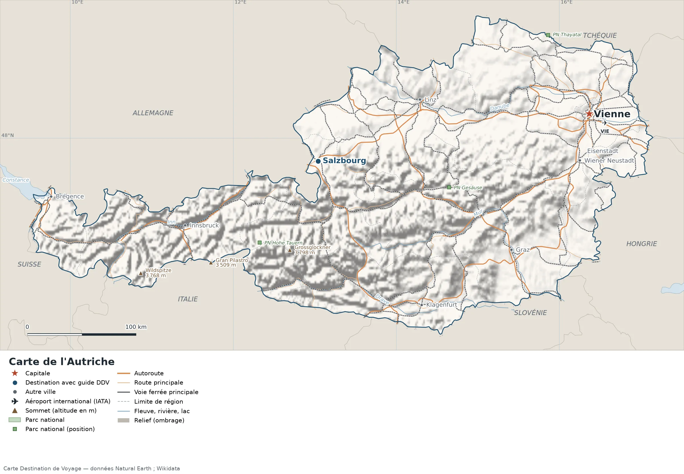
Open the full-size map (high resolution, zoomable)
Key: red star = capital; blue dot = destination covered by a Destination de Voyage guide; blue italic name = region or island with a guide; grey dot = other city; plane = international airport (IATA code); brown triangle = summit (elevation); green areas = national parks (green square = national park shown as a point); thick orange line = expressway, light orange = main road; black-and-white line = main railway; grey dashes = regional boundaries; blue = rivers and lakes; shading = terrain; grid = latitude and longitude.
Sources: base map, cities, roads, railways, airports, administrative boundaries, rivers, lakes and hillshading: Natural Earth 1:10m (public domain). National parks: Wikidata. Summits and elevations: Wikidata and Natural Earth. Places missing from Natural Earth: Wikipedia coordinates. Map produced by Destination de Voyage.
Regions and destinations on the map of Austria
| Region | Our guides | Other cities on the map |
|---|---|---|
| Salzburg | Salzburg | — |
| Vienna | Vienna | — |
| Lower Austria | — | Wiener Neustadt |
| Burgenland | — | Eisenstadt |
| Carinthia | — | Klagenfurt |
| Upper Austria | — | Linz |
| Styria | — | Graz |
| Tyrol | — | Innsbruck |
| Vorarlberg | — | Bregenz |
Straight-line distances between the main cities
Straight-line distances calculated from place coordinates (haversine formula). Actual journeys by road, rail, boat or plane are longer.
| Route | Straight-line distance |
|---|---|
| Vienna – Salzburg | 251 km (156 mi) |
| Vienna – Linz | 154 km (96 mi) |
| Vienna – Graz | 144 km (89 mi) |
| Vienna – Innsbruck | 384 km (239 mi) |
| Vienna – Klagenfurt | 234 km (145 mi) |
| Vienna – Wiener Neustadt | 44 km (27 mi) |
| Vienna – Bregenz | 498 km (309 mi) |
| Vienna – Eisenstadt | 43 km (27 mi) |
Terrain, national parks and airports
Main summits (elevations from Wikidata / Natural Earth): Grossglockner (3,798 m / 12,461 ft), Wildspitze (3,768 m / 12,362 ft), Grossvenediger (3,657 m / 11,998 ft), Gran Pilastro (3,509 m / 11,512 ft).
National parks shown (3): Gesäuse National Park, Thayatal National Park, Hohe Tauern National Park.
International airports shown: VIE (Vienna Schwechat).
Our guides by destination
The 16 regions of Austria and what sets them apart
The Natural Earth base map divides Austria into 16 first-level subdivisions (type: Bundesländ|Länd and Opcine). These are the grey dashed boundaries on the map. The table ranks them from largest to smallest, with the cities, highest point and international airports the map places in each.
| Region | Type | Area | Cities and guides | Highest point shown | Airport |
|---|---|---|---|---|---|
| Lower Austria | Bundesländ|Länd | 19,099 km² (7,374 sq mi) | Wiener Neustadt | — | VIE |
| Styria | Bundesländ|Länd | 16,440 km² (6,348 sq mi) | Graz | — | — |
| Tyrol | Bundesländ|Länd | 12,722 km² (4,912 sq mi) | Innsbruck | Grossglockner (3,798 m / 12,461 ft) | — |
| Upper Austria | Bundesländ|Länd | 11,886 km² (4,589 sq mi) | Linz | — | — |
| Carinthia | Bundesländ|Länd | 9,646 km² (3,724 sq mi) | Klagenfurt | Grossglockner (3,798 m / 12,461 ft) | — |
| Salzburg | Bundesländ|Länd | 7,206 km² (2,782 sq mi) | Salzburg | Grosses Wiesbachhorn (3,564 m / 11,693 ft) | — |
| Burgenland | Bundesländ|Länd | 3,983 km² (1,538 sq mi) | Eisenstadt | — | — |
| Vorarlberg | Bundesländ|Länd | 2,602 km² (1,005 sq mi) | Bregenz | — | — |
| Vienna (capital) | Bundesländ|Länd | 410 km² (158 sq mi) | Vienna | — | — |
| Apace | Opcine | 55 km² (21 sq mi) | — | — | — |
| Muta | Opcine | 28 km² (11 sq mi) | — | — | — |
| Kuzma | Opcine | 19 km² (7.3 sq mi) | — | — | — |
| Ruggell | — | 5.9 km² (2.3 sq mi) | — | — | — |
| Planken | — | 5.9 km² (2.3 sq mi) | — | — | — |
| Mauren | — | 3.5 km² (1.4 sq mi) | — | — | — |
| Schellenberg | — | 2.6 km² (1.0 sq mi) | — | — | — |
- Largest: Lower Austria, about 19,099 km² (7,374 sq mi), or 23% of the mapped territory.
- Smallest: Schellenberg, about 2.6 km² (1.0 sq mi).
- Capital region: Vienna lies in the Vienna subdivision.
- Highest region: Tyrol, home to Grossglockner (3,798 m / 12,461 ft), the highest summit shown on the map.
- Region best covered by our guides: Salzburg (Salzburg).
- Air access: the international airports on the map are spread across 1 of 16 regions (Lower Austria).
How to read the map of Austria
- Extent: the mapped territory covers about 83,993 km² (32,430 sq mi), according to our calculation on the Natural Earth outline; Wikidata gives 83,879 km² (32,386 sq mi). It extends from 46.38° N to 49.01° N in latitude and from 9.52° E to 17.15° E in longitude, about 293 km (182 mi) from north to south and 571 km (355 mi) from west to east (bounding rectangle, including remote territories).
- Outline: the perimeter of the territory on the map (land borders) is about 2,079 km (1,292 mi). The simplified Natural Earth outline smooths out small detours: the actual length of the borders is greater. Destination de Voyage calculation.
- Time zone (IANA tz database 2026b): Vienna:
Europe/Vienna(UTC+1 in January, UTC+2 in July). - Terrain: shading shows the relief and brown triangles mark the summits. The highest shown are Grossglockner (3,798 m / 12,461 ft), Wildspitze (3,768 m / 12,362 ft), Weisskugel (3,738 m / 12,264 ft), Grossvenediger (3,657 m / 11,998 ft), Hinterer Brochkogel (3,628 m / 11,903 ft). Wikidata gives Grossglockner (3,798 m / 12,461 ft) as the highest point.
- Rivers (blue lines): Danube, about 304 km (189 mi) traced within the territory; Mur, about 283 km (176 mi) traced within the territory; Drava, about 229 km (142 mi) traced within the territory; Inn, about 179 km (111 mi) traced within the territory; Morava, about 50 km (31 mi) traced within the territory; Rhine, about 5 km (3.1 mi) traced within the territory. Lengths measured on the simplified Natural Earth outline: Destination de Voyage calculation.
- Lakes named in Natural Earth: Lake Constance.
- National parks (green areas): 3 with their centre inside the territory, including Gesäuse National Park, Thayatal National Park and Hohe Tauern National Park. Outlines from OpenStreetMap or position from Wikidata.
- International airports (plane icon): VIE (Vienna Schwechat, about 17 km (11 mi) from the centre of Vienna). Straight-line distances: Destination de Voyage calculation.
Distances between the main cities (cross table)
Straight-line distances between the capital, our destinations and the largest cities on the map, with the direction from the first city. Roads and ferries always add distance.
| Route | Straight-line distance | Direction |
|---|---|---|
| Vienna → Salzburg | 251 km (156 mi) | west |
| Vienna → Linz | 154 km (96 mi) | west |
| Vienna → Graz | 144 km (89 mi) | southwest |
| Vienna → Innsbruck | 384 km (239 mi) | west |
| Vienna → Klagenfurt | 234 km (145 mi) | southwest |
| Vienna → Wiener Neustadt | 44 km (27 mi) | south |
| Salzburg → Linz | 109 km (68 mi) | northeast |
| Salzburg → Graz | 196 km (122 mi) | southeast |
| Salzburg → Innsbruck | 136 km (85 mi) | southwest |
| Salzburg → Klagenfurt | 163 km (101 mi) | southeast |
| Salzburg → Wiener Neustadt | 240 km (149 mi) | east |
| Linz → Graz | 162 km (101 mi) | southeast |
| Linz → Innsbruck | 244 km (152 mi) | southwest |
| Linz → Klagenfurt | 189 km (117 mi) | south |
| Linz → Wiener Neustadt | 156 km (97 mi) | east |
| Graz → Innsbruck | 303 km (188 mi) | west |
| Graz → Klagenfurt | 98 km (61 mi) | southwest |
| Graz → Wiener Neustadt | 104 km (65 mi) | northeast |
Typical itineraries in Austria based on the map
To link our 2 destinations without backtracking, here is the shortest order step by step, starting from the point closest to Vienna (nearest-neighbour method, straight-line distances): Vienna → Salzburg (251 km / 156 mi). Total: about 251 km (156 mi) in a straight line. Adjust for flights, ferries and the season.
- Our complete guide to Austria: must-sees, detailed itineraries and budget
- When to go to Austria: best time to visit and month-by-month climate
- For a trip combined with a neighbouring country: map of Germany, map of Hungary, map of Italy, map of Slovenia and map of Switzerland.
Frequently asked questions
What is the capital of Austria?
Vienna, marked by the red star on the map.
Which of our guide destinations is farthest from Vienna?
Salzburg, about 251 km (156 mi) in a straight line (Destination de Voyage calculation).
Which countries border Austria?
Countries sharing a land border: Germany, Hungary, Italy, Liechtenstein, Slovakia, Slovenia, Switzerland and Czechia.
What is the highest summit shown on the map?
Grossglockner, at 3,798 m (12,461 ft) elevation (source: Natural Earth).
Which international airports are on the map?
VIE (Vienna Schwechat).
Where is Vienna on the map of Austria?
At 48.20° N and 16.36° E, marked by the red star, in the Vienna subdivision.
How many regions does Austria have?
Our map, based on Natural Earth, shows 16 first-level subdivisions (Bundesländ|Länd and Opcine). Wikidata lists 9 entities of type “state of Austria” attached directly to the territory; the official division may differ from the one on the map.
Where is Austria?
Continent: Europe (Wikidata). Austria lies in the northern hemisphere, east of the Greenwich meridian. Land borders: Germany, Hungary, Italy, Liechtenstein, Slovakia, Slovenia, Switzerland and Czechia.
Where is Salzburg?
About 251 km (156 mi) west of Vienna in a straight line, in the Salzburg subdivision (Destination de Voyage calculation). All our advice: Salzburg.
What is the area of Austria?
About 83,993 km² (32,430 sq mi) according to our calculation on the Natural Earth outline; Wikidata gives 83,879 km² (32,386 sq mi). Differences come from the precision of the coastline and inland waters.
Our sources
- Natural Earth 1:10m (public domain): country and subdivision boundaries, cities, airports, rivers, lakes, terrain, at naturalearthdata.com.
- Wikidata, item Q40 (Austria): area, highest point, continent and subdivisions, accessed 23 October 2026.
- Wikidata: location of national parks and elevation of summits.
- Wikipedia: coordinates of places missing from Natural Earth.
- Destination de Voyage calculations: distances (haversine, radius 6,371 km), directions and areas (WGS84 ellipsoid, pyproj library).
- Our methodology