
Shaped like a boot, Italy stretches from the Alps to Sicily, between the Tyrrhenian, Ionian and Adriatic seas. This map of Italy shows Rome, the major cities, the lakes, the islands and all the regions covered by our guides.

Our travel deals for Map
Affiliate links: we earn a commission, at no extra cost to you.
 FlightsKiwi.comCompare flights and airline combinations to Map.Compare flights

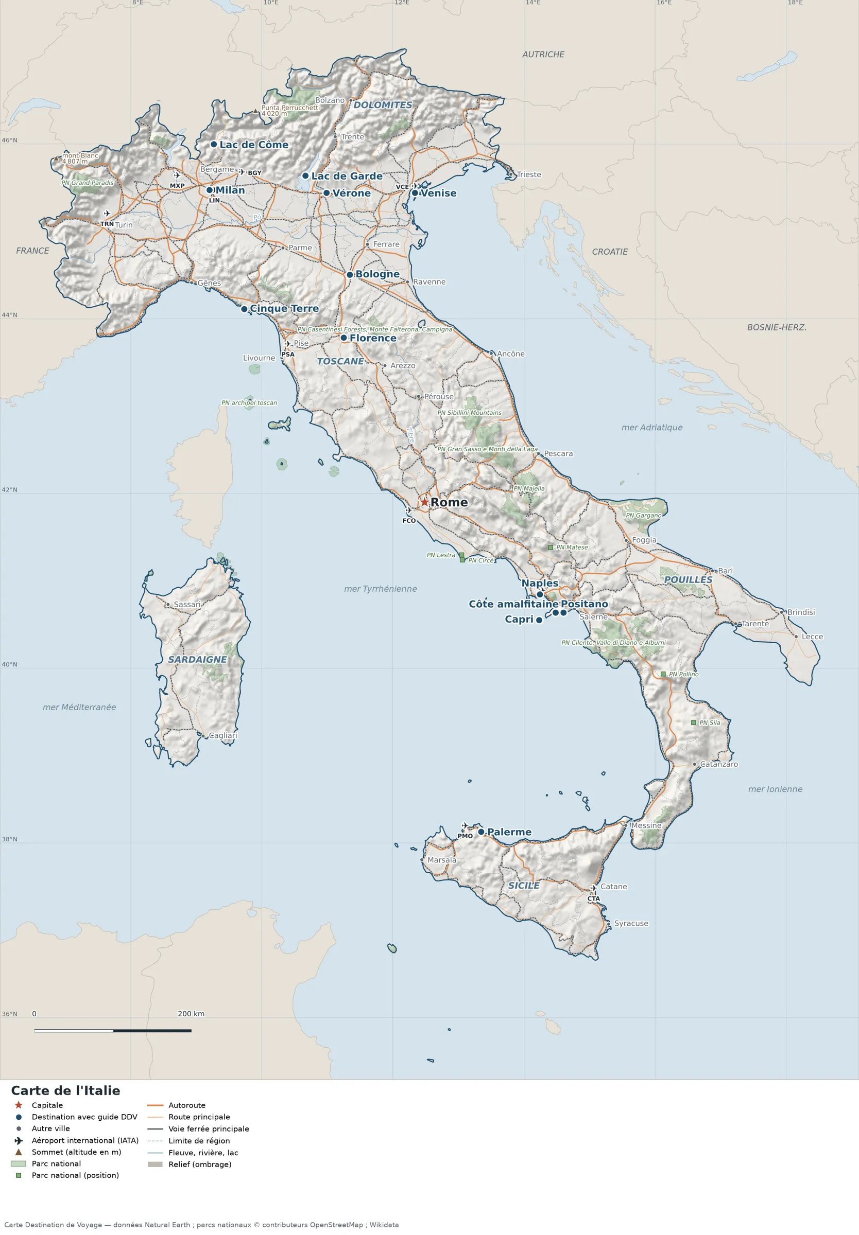
Open the full-size map (high resolution, zoomable)
Key: red star = capital; blue dot = destination covered by a Destination de Voyage guide; grey dot = other city; plane = international airport (IATA code); brown triangle = summit (elevation); green areas = national parks; thick orange line = expressway, light orange = main road; black-and-white line = main railway; grey dashes = regional or prefectural boundaries; blue = rivers and lakes; shading = terrain; grid = latitude and longitude.
Sources: base map, cities, roads, railways, airports, administrative boundaries, rivers, lakes, summits and hillshading: Natural Earth 1:10m (public domain). National parks: © OpenStreetMap contributors (ODbL licence) and Wikidata. Summits: Wikidata and Natural Earth. Places missing from Natural Earth (islands, lakes, natural sites): Wikipedia coordinates. Map produced by Destination de Voyage.
Terrain and national parks
Main summits (elevations from Wikidata / Natural Earth): Mont Blanc (4,807 m / 15,771 ft), Monte Rosa (4,634 m / 15,203 ft), Gran Paradiso (4,061 m / 13,323 ft), Punta Perrucchetti (4,020 m / 13,189 ft).
National parks shown (27, based on OpenStreetMap and Wikidata): the largest are labelled directly on the map.
Regions and destinations on the map of Italy
| Region | Cities and places (links to our guides) |
|---|---|
| Lombardy | Milan, Lake Como |
| Veneto | Venice, Verona |
| Lake Garda (Lombardy, Veneto, Trentino) | Lake Garda |
| Dolomites (Northeast Alps) | Dolomites |
| Liguria | Cinque Terre, Genoa |
| Piedmont | Turin |
| Emilia-Romagna | Bologna |
| Tuscany | Tuscany, Florence |
| Lazio | Rome |
| Campania | Naples, Amalfi Coast |
| Puglia | Puglia, Bari |
| Sicily | Sicily, Palermo, Catania |
| Sardinia | Sardinia, Cagliari |
Straight-line distances between the main cities
Straight-line distances calculated from the coordinates of the cities (haversine formula). Actual journeys by road, rail or ferry are longer.
| Route | Straight-line distance |
|---|---|
| Rome – Florence | 232 km (144 mi) |
| Rome – Naples | 188 km (117 mi) |
| Florence – Venice | 203 km (126 mi) |
| Milan – Venice | 244 km (152 mi) |
| Milan – Rome | 477 km (296 mi) |
| Florence – Bologna | 80 km (50 mi) |
| Rome – Palermo | 426 km (265 mi) |
Our Italy guides by destination
- Rome
- Milan
- Venice
- Florence
- Naples
- Bologna
- Verona
- Palermo
- Cinque Terre
- Amalfi Coast
- Lake Como
- Lake Garda
- Dolomites
- Tuscany
- Puglia
- Sicily
- Sardinia
- All our advice for the country: Italy
Frequently asked questions
What is the capital of Italy?
Rome, in Lazio, in the center-west of the peninsula. See our Rome guide.
How far is Rome from Florence?
About 232 km (144 mi) in a straight line (Destination de Voyage calculation).
Which countries border Italy?
France, Switzerland, Austria and Slovenia; San Marino and the Vatican City are enclaves within Italian territory.
Where are Italy’s lakes?
Lake Como and Lake Garda are in the north, at the foot of the Alps: Lake Como north of Milan, Lake Garda between Milan and Verona.