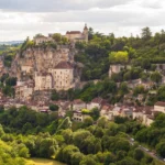
Rocamadour is a town clinging to a cliff more than 100 metres (330 ft) above the Alzou canyon, in the Lot department. A place of pilgrimage since the 12th century centred on the Black Madonna, it is organised on three stacked levels: the medieval town at the bottom, the sanctuaries in the middle and the castle at the top. This guide to visit Rocamadour explains how to move from one level to another (stairs, Way of the Cross, lifts), what to see, where to park and how to combine the visit with the Gouffre de Padirac.
To plan your visit to Rocamadour, remember that everything comes down to the climb: the 216 to 220 steps (depending on the source) of the Grand Staircase link the town with the sanctuaries. The Gouffre de Padirac, often visited the same day, is only about 12 km (7 mi) away as the crow flies (Destination de Voyage calculation).

Our travel deals for Rocamadour
Affiliate links: we earn a commission, at no extra cost to you.
 FlightsKiwi.comCompare flights and airline combinations to Rocamadour.Compare flights

Rocamadour at a glance
- Department Lot (Occitanie region), Causses du Quercy Regional Nature Park
- Three levels L’Hospitalet and the castle at the top, the sanctuaries in the middle, the medieval town at the bottom
- Grand Staircase 216 steps between the town and the sanctuaries
- Lifts two, one between the town and the sanctuaries, the other between the sanctuaries and the castle (tourist office)
- Car parks P1 L’Hospitalet, P2 Le Château, P5 La Vallée (tourist office)
- Train Rocamadour-Padirac station, outside the town: plan on a taxi or a car
- Entry Schengen rules for France; see entry requirements
- Time needed half a day to a full day
Understanding Rocamadour: the three levels
The first challenge is knowing where to start. The table below sums up the three levels and how to get from one to the other.
| Level | What you find there | Going up or down | Nearest car park |
|---|---|---|---|
| Top: L’Hospitalet and the castle | Viewpoints over the town, castle ramparts, Jerusalem cross | Way of the Cross (on foot) or castle-sanctuaries lift | P1 Hospitalet, P2 Château |
| Middle: the sanctuaries | Basilica of Saint-Sauveur, crypt of Saint-Amadour, Notre-Dame chapel and Black Madonna, chapels, museum of sacred art | Grand Staircase (more than 200 steps) or town-sanctuaries lift | Reached from one of the other two levels |
| Bottom: the medieval town | Shopping street, fortified gates, restaurants | Grand Staircase up to the sanctuaries | P5 La Vallée (valley floor) |
Which route to choose?
- From the top (Château car park): a gentle descent along the Way of the Cross to the sanctuaries, then the Grand Staircase and the shopping street. The tourist office suggests the two lifts as an alternative for coming back up.
- From the bottom (Vallée car park): you start from the Alzou canyon; according to the tourist office’s « parking de la Vallée » page, two routes of 2 h 30 and 3 h start from this car park.
- From L’Hospitalet: ideal for starting with the overall view of the cliff from the viewpoints, then walking down.
- Reduced mobility, strollers: use the lifts and ask the tourist office; lanes and steps remain numerous.
Things to do in Rocamadour
The medieval town
At the bottom, the town with its winding lanes is guarded by a series of fortified gates: Porte Salmon, Porte Cabilière, Porte de l’Hôpital and Porte du Figuier. The main street concentrates shops and restaurants.
The Grand Staircase and the sanctuaries
Pilgrims once climbed the 216 to 220 steps (depending on the source) of the Grand Staircase on their knees, and some still do. At the top, the sanctuaries’ esplanade brings together the Basilica of Saint-Sauveur and the crypt of Saint-Amadour, both World Heritage-listed, as well as the chapels of Sainte-Anne, Saint-Blaise, Saint-Jean-Baptiste, Saint-Michel and Notre-Dame. All the buildings of the religious town have been listed as historic monuments since 2000.
The Notre-Dame chapel and the Black Madonna
The heart of the pilgrimage, the Notre-Dame chapel houses the statue of the Black Madonna, dated to the 12th century. Model boats hung as ex-votos and the so-called miraculous bell recall the sanctuary’s link with sailors. It is an active place of worship: Mass times, off-season and in summer, are published by the sanctuary and the tourist office; keep silent during services.
The museum of sacred art
Housed in the bishops’ palace, renovated and reopened in 1996, the museum displays on five levels about a hundred works of sacred art given to the sanctuary.
The castle and the Way of the Cross
A Way of the Cross winds up the cliff to the castle and the Jerusalem cross, where a viewpoint has been laid out. Further on, the hamlet of L’Hospitalet, founded in 1095 to welcome pilgrims, offers the best-known view of the town.
Nearby: the Forêt des Singes and Rocamadour cheese
In the municipality, the Forêt des Singes keeps Barbary macaques, an endangered species, in semi-freedom over 20 hectares (49 acres). At the table, Rocamadour has given its name to a small goat’s cheese, the rocamadour, with protected designation (AOC) since 1996.
On its Rocamadour page, Lot Tourisme also features the Grotte des Merveilles, known for its formations and cave paintings, and points out that the Causses du Quercy are a UNESCO Global Geopark.
Itinerary: Rocamadour and Padirac in one day
The Gouffre de Padirac is about 12 km (7 mi) from Rocamadour as the crow flies. The two visits combine easily: Padirac in the morning (check the booking arrangements on the chasm’s website; the visit is underground and cool all year round), Rocamadour in the afternoon, ending with the view from L’Hospitalet late in the day.
| Site | Interest | Straight-line distance |
|---|---|---|
| Gouffre de Padirac | Chasm and underground river | about 12 km (7 mi) |
| Collonges-la-Rouge | Red sandstone village (Corrèze) | about 29 km (18 mi) |
| Domme | Bastide town above the Dordogne | about 32 km (20 mi) |
| Sarlat | Medieval town of the Périgord Noir | about 33 km (21 mi) |
| Saint-Cirq-Lapopie | Hilltop village above the Lot | about 37 km (23 mi) |
| Château de Castelnaud | Fortified castle in the Dordogne valley | about 37 km (23 mi) |
| Montignac-Lascaux | Lascaux cave (replica) | about 47 km (29 mi) |
When to go to Rocamadour
There is no published Météo-France data sheet for Rocamadour; the nearest reference station is Gourdon, about 19 km (12 mi) away as the crow flies (Destination de Voyage calculation). May, June and September are the best months: 21.5 to 25.2 °C (71 to 77 °F) in the afternoon in May-June, 23.7 °C (75 °F) in September. July and August are hot (27.6 °C / 82 °F); the tourist office has a page on the times when parking is easier. In winter the weather is cool and damp, with about ten frost days a month in December and January.
| Month | High | Low | Rain | Rain days | Sun / day | Sun vs Paris | Verdict |
|---|---|---|---|---|---|---|---|
| January | 9.0 °C (48 °F) | 2.0 °C (36 °F) | 64.7 mm (2.5 in) | 10.7 | 3.0 h | +1.1 h | ⚠️ Cold, damp |
| February | 10.8 °C (51 °F) | 1.7 °C (35 °F) | 50.8 mm (2.0 in) | 9.1 | 4.3 h | +1.3 h | ⚠️ Cold, frequent frost |
| March | 14.8 °C (59 °F) | 4.2 °C (40 °F) | 61.0 mm (2.4 in) | 10.2 | 5.5 h | +1.1 h | ⚠️ Cool |
| April | 17.7 °C (64 °F) | 6.4 °C (44 °F) | 82.6 mm (3.3 in) | 11.2 | 6.0 h | +0.1 h | ✅ Mild, spring |
| May | 21.5 °C (71 °F) | 9.6 °C (49 °F) | 82.2 mm (3.2 in) | 11.1 | 6.9 h | +0.4 h | ✅ Ideal for the stairs |
| June | 25.2 °C (77 °F) | 12.8 °C (55 °F) | 76.2 mm (3.0 in) | 8.7 | 8.1 h | +1.3 h | ✅ Long sunny days, ideal |
| July | 27.6 °C (82 °F) | 14.5 °C (58 °F) | 54.7 mm (2.2 in) | 6.7 | 8.5 h | +1.4 h | ⚠️ Hot, ~10 days ≥ 30 °C |
| August | 27.8 °C (82 °F) | 14.5 °C (58 °F) | 63.2 mm (2.5 in) | 7.7 | 8.1 h | +1.2 h | ⚠️ Hot, ~10 days ≥ 30 °C |
| September | 23.7 °C (75 °F) | 11.4 °C (53 °F) | 73.7 mm (2.9 in) | 8.9 | 7.0 h | +1.1 h | ✅ Ideal, still mild |
| October | 18.9 °C (66 °F) | 9.3 °C (49 °F) | 70.5 mm (2.8 in) | 10.0 | 4.8 h | +1.0 h | ✅ Mild, autumn colours |
| November | 12.6 °C (55 °F) | 5.0 °C (41 °F) | 76.2 mm (3.0 in) | 11.4 | 3.2 h | +0.8 h | ⚠️ Rainy, cool |
| December | 9.5 °C (49 °F) | 2.6 °C (37 °F) | 67.2 mm (2.6 in) | 11.0 | 2.9 h | +1.1 h | ⚠️ Cool, damp |
With 9.8 days above 30 °C (86 °F) in July and 10.3 in August on average (Météo-France, Gourdon), climb the Grand Staircase early in the morning in summer. The sanctuary hosts an annual pilgrimage; its calendar is published by the sanctuary.
Getting to Rocamadour
- By car: the easiest way to explore the area; Sarlat is about 33 km (21 mi) away as the crow flies (Destination de Voyage calculation based on Wikipedia coordinates), and the road distance is longer.
- By train: Rocamadour-Padirac station, on the Brive-Toulouse line via Capdenac (Wikipedia), is outside the town; plan on a taxi for the last stretch.
Where to stay in Rocamadour
| Area | Best for | Strengths |
|---|---|---|
| L’Hospitalet | Views, arriving by car | Viewpoints, close to the upper car parks |
| The town | Sleeping at the foot of the sanctuaries | Everything on foot; car access more restricted |
| Causse countryside | Families, longer stays | Quiet, dark night skies; a car is essential |
| Dordogne valley | Combining with Padirac and Sarlat | A more central base for day trips |
Entry requirements, health and safety
- US citizens: no visa for up to 90 days in the Schengen area, including France, for tourism or business; your passport should be valid at least three months beyond your stay, and you may be asked for proof of funds and a return ticket (U.S. Department of State, travel.state.gov, last updated August 11, 2025).
- UK citizens: no visa for up to 90 days in any 180-day period; your passport must have been issued less than 10 years before arrival and be valid at least 3 months after you leave the Schengen area. Under the EU Entry/Exit System (EES), fingerprints and a photo may be taken at your first entry (UK FCDO, GOV.UK, updated 22 October 2026).
- Health: UK travellers need a GHIC or valid EHIC for state healthcare; everyone should have travel insurance covering medical costs. Emergency numbers: 15 (medical), 17 (police), 18 (fire), 112 (European emergency number) (GOV.UK, travel.state.gov).
Practical tips for Rocamadour
- Shoes: stairs and cobbled lanes everywhere; avoid smooth-soled sandals.
- Shade: the tourist office gives advice on parking in the shade in summer.
- Lifts: conditions, prices and opening hours from the tourist office.
- Place of worship: modest dress and silence in the chapels.
Frequently asked questions
How many steps are there in Rocamadour?
The Grand Staircase has more than 200 steps (216 according to Wikipedia, 220 according to the tourist office) between the medieval town and the sanctuaries. A Way of the Cross then links the sanctuaries with the castle. Two lifts let you avoid the climb.
Where do you park in Rocamadour?
The main public car parks are P1 L’Hospitalet, P2 Le Château and P5 La Vallée. The choice depends on your route: from the top to walk down, from the valley to walk up.
How long does it take to visit Rocamadour?
Half a day is enough for the town, the sanctuaries and the castle. The tourist office describes routes of 2 h 30 to 3 h from the Vallée car park.
Can you do Rocamadour and Padirac on the same day?
Yes. The Gouffre de Padirac is about 12 km (7 mi) away as the crow flies; do Padirac in the morning and Rocamadour in the afternoon.
Is Rocamadour in the Dordogne?
No: Rocamadour is in the Lot, in the Occitanie region, but it is often visited from the Dordogne valley and Sarlat.
Our sources
- Météo-France: climate data sheet, 1991-2020 statistics, Gourdon station (Lot, 260 m); Paris-Montsouris station for comparison (sheets consulted on 23 October 2026)
- Vallée de la Dordogne tourist office (vallee-dordogne.com: Rocamadour practical information, parking, Vallée car park, lifts pages), consulted on 23 October 2026
- Lot Tourisme (tourisme-lot.com, Rocamadour page), consulted on 23 October 2026
- Wikipedia: « Rocamadour » (history, monuments, Grand Staircase, access), consulted on 23 October 2026
- Destination de Voyage calculation: straight-line distances (Wikipedia coordinates), sun per day vs Paris
- Entry requirements, health and safety checked on 26 October 2026: U.S. Department of State, France country information (last updated August 11, 2025) and UK FCDO, GOV.UK foreign travel advice for France (updated 22 October 2026).
- Our methodology
Updated October 2026.
To extend your trip, see our guide to the Dordogne, our page on Toulouse and our other destinations in France.