This map of North Macedonia shows the capital, Skopje, the 2 destinations covered in our guides and the main towns, with the national parks, expressways, railways and rivers.

Our travel deals for Map
Affiliate links: we earn a commission, at no extra cost to you.
 FlightsKiwi.comCompare flights and airline combinations to Map.Compare flights

Safety (UK FCDO and U.S. Department of State, read on 12 November 2026): the U.S. Department of State rates North Macedonia Level 1, Exercise Normal Precautions (travel advisory dated September 9, 2026), and the UK FCDO (GOV.UK, updated 13 August 2026) does not advise against travel to any part of the country. Sources: GOV.UK, North Macedonia travel advice and travel.state.gov, International Travel Country Information (North Macedonia page last updated September 10, 2026).
Neighbouring countries (land border): Albania, Bulgaria, Greece, Kosovo and Serbia.
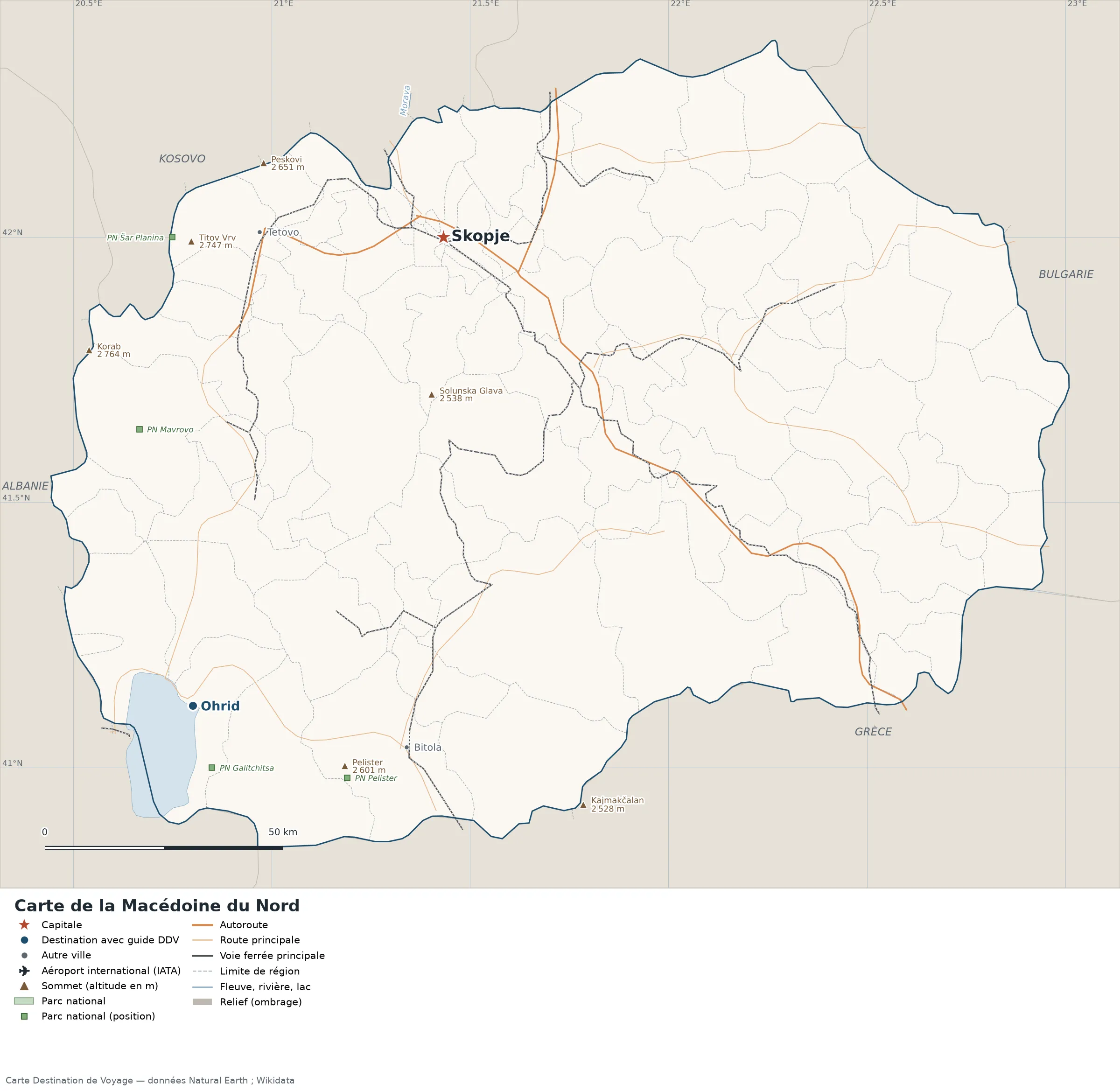
Open the full-size map (high resolution, zoomable)
Key: red star = capital; blue dot = destination covered by a Destination de Voyage guide; blue italic name = region or island with a guide; grey dot = other city; plane = international airport (IATA code); brown triangle = summit (elevation); green areas = national parks (green square = national park shown as a point); thick orange line = expressway, light orange = main road; black-and-white line = main railway; grey dashes = regional boundaries; blue = rivers and lakes; shading = terrain; grid = latitude and longitude.
Sources: base map, cities, roads, railways, airports, administrative boundaries, rivers, lakes and hillshading: Natural Earth 1:10m (public domain). National parks: Wikidata. Summits and elevations: Wikidata and Natural Earth. Places missing from Natural Earth: Wikipedia coordinates. Map produced by Destination de Voyage.
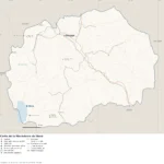
Regions and destinations on the map of North Macedonia
| Region | Our guides | Other cities on the map |
|---|---|---|
| Ohrid | Ohrid | — |
| Čair | Skopje | — |
| Bitola | — | Bitola |
| Tetovo | — | Tetovo |
Straight-line distances between the main cities
Straight-line distances calculated from the coordinates of the places (haversine formula). Actual journeys by road, rail, ferry or air are longer.
| Route | Straight-line distance |
|---|---|
| Skopje – Ohrid | 111 km (69 mi) |
| Skopje – Bitola | 107 km (66 mi) |
| Skopje – Tetovo | 38 km (24 mi) |
Terrain, national parks and airports
Main summits (elevations from Wikidata / Natural Earth): Korab (2,764 m / 9,068 ft), Peskovi (2,651 m / 8,698 ft), Pelister (2,601 m / 8,533 ft), Solunska Glava (2,538 m / 8,327 ft), Kajmakčalan (2,528 m / 8,294 ft).
National parks shown (4): Galičica National Park, Mavrovo National Park, Pelister National Park, Šar Planina National Park.
Our guides by destination
Frequently asked questions
What is the capital of North Macedonia?
Skopje, shown by the red star on the map.
What is the destination in our guides farthest from Skopje?
Ohrid, about 111 km (69 mi) in a straight line (Destination de Voyage calculation).
Which countries border North Macedonia?
Countries sharing a land border: Albania, Bulgaria, Greece, Kosovo and Serbia.
What is the highest summit shown on the map?
Korab, at 2,764 m (9,068 ft) (source: Natural Earth).