
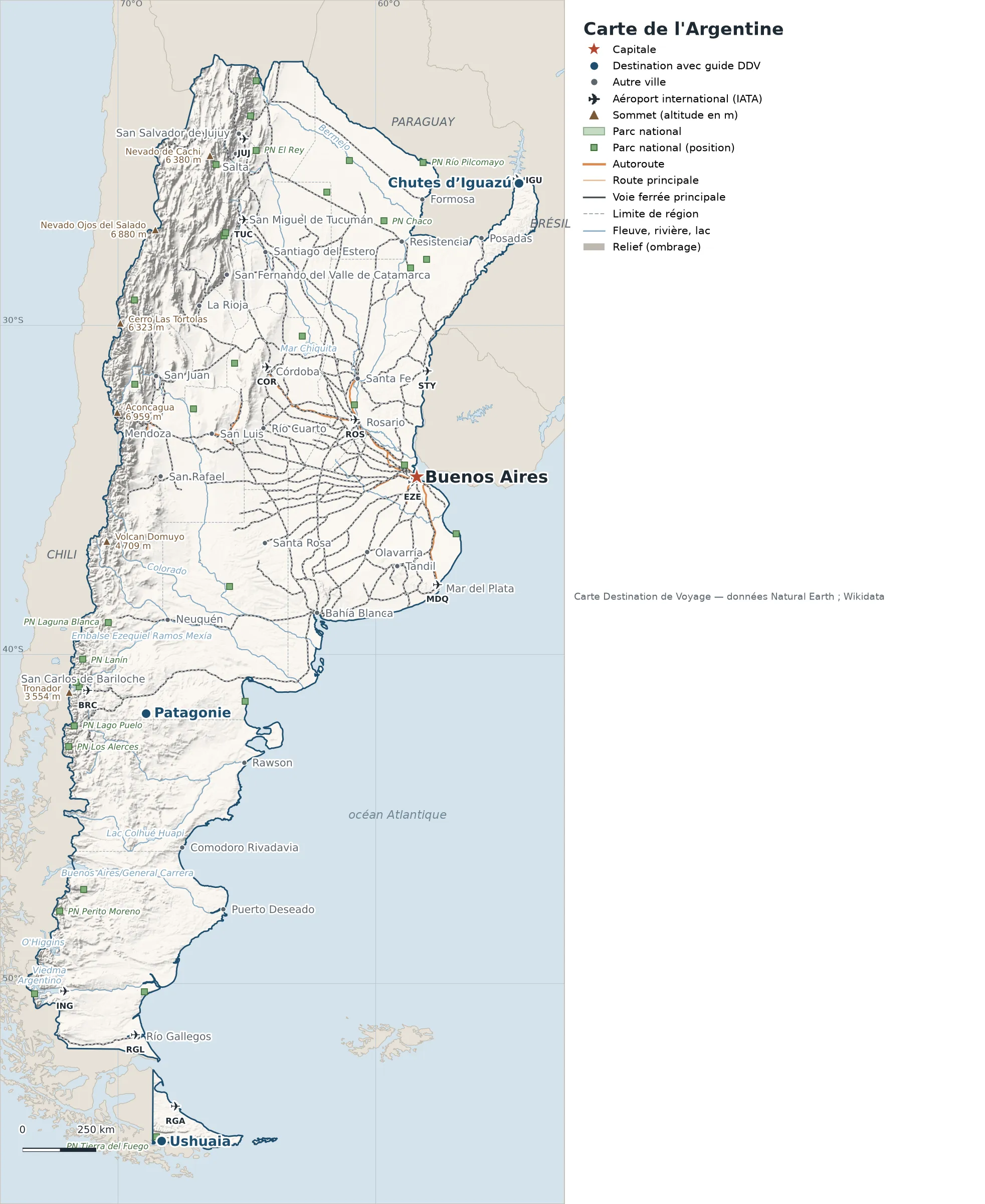
This map of Argentina shows the capital, Buenos Aires, the 4 destinations covered in our guides and the main cities, with terrain, national parks, expressways, railways, rivers and international airports.
Neighbouring countries (land border): Bolivia, Brazil, Chile, Paraguay and Uruguay. Its coasts face: Bahía Blanca, Bahía Grande, San Jorge Gulf, Río de la Plata, Strait of Magellan and San Matías Gulf.

Our travel deals for Map
Affiliate links: we earn a commission, at no extra cost to you.
 FlightsKiwi.comCompare flights and airline combinations to Map.Compare flights
- eSIMSailyAnother eSIM plan to compare: data, validity, network.See Saily plans


Open the full-size map (high resolution, zoomable)
Key: red star = capital ; blue dot = destination covered by a Destination de Voyage guide ; blue italic name = region or island with a guide ; grey dot = other city ; plane = international airport (IATA code) ; brown triangle = summit (elevation) ; green areas = national parks (green square = national park located by a point) ; thick orange line = expressway, light orange = main road ; black-and-white line = main railway ; grey dashes = regional boundaries ; blue = rivers and lakes ; shading = terrain ; grid = latitude and longitude.
Sources: base map, cities, roads, railways, airports, administrative boundaries, rivers, lakes and hillshading: Natural Earth 1:10m (public domain). National parks: Wikidata. Summits and elevations: Wikidata and Natural Earth. Places missing from Natural Earth: Wikipedia coordinates. Map produced by Destination de Voyage.
Regions and destinations on the map of Argentina
| Region | Our guides | Other cities on the map |
|---|---|---|
| Buenos Aires | Buenos Aires | Mar del Plata, Bahía Blanca, Tandil, Olavarría |
| Misiones | Iguazú Falls | Posadas |
| Río Negro | Patagonia | San Carlos de Bariloche |
| Tierra del Fuego | Ushuaia | Río Grande |
| Chubut | — | Comodoro Rivadavia |
| Córdoba | — | Córdoba |
| Formosa | — | Formosa |
| Mendoza | — | Mendoza |
| Neuquén | — | Neuquén |
| Salta | — | Salta |
| San Juan | — | San Juan |
| Santa Cruz | — | Río Gallegos |
| Santa Fe | — | Rosario |
| Tucumán | — | San Miguel de Tucumán |
Straight-line distances between the main cities
Straight-line distances calculated from place coordinates (haversine formula). Actual journeys by road, rail, boat or plane are longer.
| Route | Straight-line distance |
|---|---|
| Buenos Aires – Ushuaia | 2,372 km (1,474 mi) |
| Buenos Aires – Patagonia | 1,217 km (756 mi) |
| Buenos Aires – Iguazú Falls | 1,061 km (659 mi) |
| Buenos Aires – Córdoba | 646 km (401 mi) |
| Buenos Aires – Mendoza | 982 km (610 mi) |
| Buenos Aires – Mar del Plata | 385 km (239 mi) |
| Buenos Aires – Posadas | 840 km (522 mi) |
| Buenos Aires – Bahía Blanca | 575 km (357 mi) |
| Ushuaia – Patagonia | 1,444 km (897 mi) |
Terrain, national parks and airports
Main summits (elevations from Wikidata / Natural Earth): Aconcagua (6,959 m / 22,831 ft), Nevado Ojos del Salado (6,880 m / 22,572 ft), Monte Pissis (6,795 m / 22,293 ft), Llullaillaco (6,739 m / 22,110 ft), Mercedario (6,668 m / 21,877 ft).
National parks shown (33): the largest are labelled directly on the map.
International airports shown: ROS (Rosario – Islas Malvinas), STY (Nueva Hespérides), BRC (Teniente Luis Candelaria), JUJ (Gob. Horacio Guzman), RGA (Hermes Quijada), RGL (Piloto Civil Norberto Fernandez), TUC (Teniente Gen. Benjamin Matienzo), ING (Com. Armando Tola), IGU (Foz do Iguaçu), MDQ (Astor Piazzolla), COR (Ingeniero Ambrosio L.V. Taravella), EZE (Ministro Pistarini).
Our Argentina guides by destination
Frequently asked questions
What is the capital of Argentina?
Buenos Aires, marked by the red star on the map.
Which of our guide destinations is farthest from Buenos Aires?
Ushuaia, about 2,372 km (1,474 mi) in a straight line (Destination de Voyage calculation).
Which countries border Argentina?
Countries sharing a land border: Bolivia, Brazil, Chile, Paraguay and Uruguay.
What is the highest summit shown on the map?
Aconcagua, at an elevation of 6,959 m (22,831 ft) (source: Natural Earth).
Which international airports are on the map?
ROS (Rosario – Islas Malvinas), STY (Nueva Hespérides), BRC (Teniente Luis Candelaria), JUJ (Gob. Horacio Guzman), RGA (Hermes Quijada), RGL (Piloto Civil Norberto Fernandez), TUC (Teniente Gen. Benjamin Matienzo), ING (Com. Armando Tola), IGU (Foz do Iguaçu), MDQ (Astor Piazzolla), COR (Ingeniero Ambrosio L.V. Taravella), EZE (Ministro Pistarini).