
This map of Mexico shows the capital, Mexico City, the 4 destinations covered in our guides and the main cities, with terrain, national parks, expressways, railways, rivers and international airports.
Neighbouring countries (land border): Belize, Guatemala and the United States. Its coasts border the Gulf of Tehuantepec, the Bay of Campeche, the Yucatán Channel, the Gulf of California, the Gulf of Mexico and the Caribbean Sea.

Our travel deals for Map
Affiliate links: we earn a commission, at no extra cost to you.
 FlightsKiwi.comCompare flights and airline combinations to Map.Compare flights
- eSIMAiraloData plan to install before you leave (eSIM-compatible phone).See plans


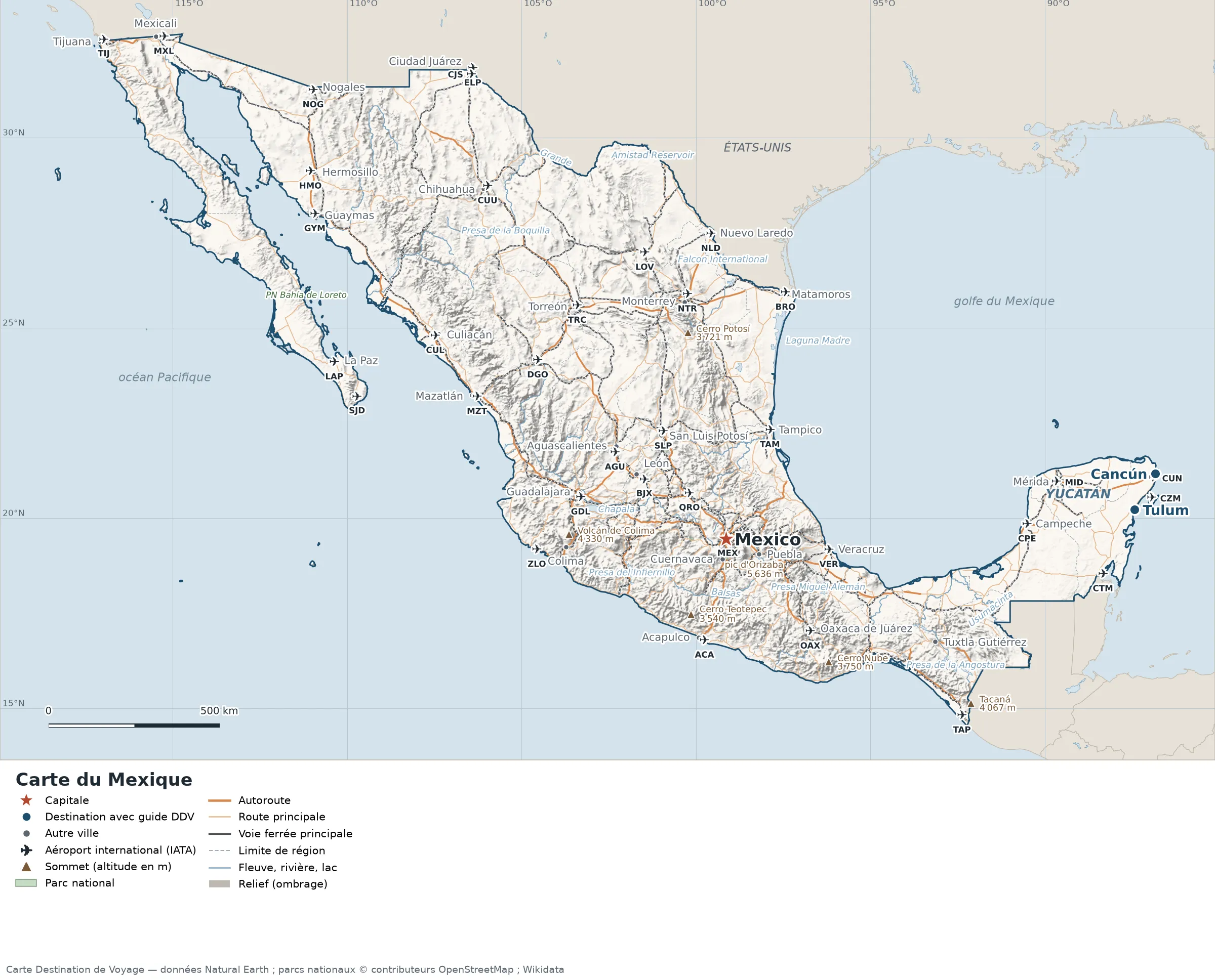
Open the full-size map (high resolution, zoomable)
Key: red star = capital; blue dot = destination covered by a Destination de Voyage guide; blue italic name = region or island with a guide; grey dot = other city; plane = international airport (IATA code); brown triangle = summit (elevation); green areas = national parks (green square = national park shown as a point); thick orange line = expressway, light orange = main road; black-and-white line = main railway; grey dashes = regional boundaries; blue = rivers and lakes; shading = terrain; grid = latitude and longitude.
Sources: base map, cities, roads, railways, airports, administrative boundaries, rivers, lakes and hillshading: Natural Earth 1:10m (public domain). National parks: © OpenStreetMap contributors (ODbL licence) and Wikidata. Summits and elevations: Wikidata and Natural Earth. Places missing from Natural Earth: Wikipedia coordinates. Map produced by Destination de Voyage.
Regions and destinations on the map of Mexico
| Region | Our guides | Other cities on the map |
|---|---|---|
| Mexico City | Mexico City | — |
| Quintana Roo | Tulum, Cancún | Chetumal |
| Yucatán | Yucatán | Mérida |
| Baja California | — | Tijuana |
| Chiapas | — | Tuxtla Gutiérrez |
| Chihuahua | — | Chihuahua |
| Guanajuato | — | León |
| Guerrero | — | Acapulco |
| Jalisco | — | Guadalajara |
| Nuevo León | — | Monterrey |
| Puebla | — | Puebla |
| Sinaloa | — | Mazatlán |
| Tamaulipas | — | Tampico |
| Veracruz | — | Veracruz |
Straight-line distances between the main cities
Straight-line distances calculated from place coordinates (haversine formula). Actual journeys by road, rail, boat or plane are longer.
| Route | Straight-line distance |
|---|---|
| Mexico City – Cancún | 1,297 km (806 mi) |
| Mexico City – Tulum | 1,227 km (762 mi) |
| Mexico City – Monterrey | 703 km (437 mi) |
| Mexico City – Guadalajara | 459 km (285 mi) |
| Mexico City – Puebla | 107 km (66 mi) |
| Mexico City – Tijuana | 2,302 km (1,430 mi) |
| Mexico City – Mérida | 1,007 km (626 mi) |
| Mexico City – Tampico | 344 km (214 mi) |
| Tulum – Cancún | 123 km (76 mi) |
Terrain, national parks and airports
Main summits (elevations from Wikidata / Natural Earth): Pico de Orizaba (5,636 m / 18,491 ft), Popocatépetl (5,420 m / 17,782 ft), La Malinche (4,462 m / 14,639 ft), Volcán de Colima (4,330 m / 14,206 ft), Cofre de Perote (4,282 m / 14,049 ft).
National parks shown (21): Big Bend National Park, Parque Nacional Arrecifes de Cozumel, Parque Nacional Arrecifes de Xcalak, Parque Nacional Bahía de Loreto, Parque Nacional Bosencheve, Parque Nacional Cerro de Garnica, Parque Nacional Costa Occidental de Isla Mujeres, Punta Cancún y Punta Nizuc, Parque Nacional Desierto de los Leones, Parque Nacional Dzibilchantún, Parque Nacional El Tepozteco, Parque Nacional El Veladero, Parque Nacional Gogorrón, Parque Nacional Insurgente José María Morelos, Parque Nacional Lagunas de Montebello, Parque Nacional Lagunas de Zempoala, Parque Nacional Mirador-Río Azul, Parque Nacional Sistema Arrecifal Veracruzano, Parque Nacional Tulum, Parque Nacional Volcán Nevado de Colima, Sierra del Lacandón National Park, Subzona de Preservación – Parque Nacional El Tepozteco.
International airports shown: BJX (Del Bajio), BRO (Brownsville-South Padre Island), CTM (Chetumal), CZM (Cozumel), DGO (Durango), LOV (Venustiano Carranza), MXL (Gen R.S. Taboada), QRO (Queretaro), SJD (Los Cabos), TAP (Tapachula), AGU (Lic. Jesús Terán Peredo), ELP (El Paso), ZLO (Playa de Oro), LAP (Gen. Márquez de León), CJS (Ciudad Juarez), CPE (Ign. Alberto Ongay), GYM (Gen. José M. Yáñez), HMO (Gen. Ignacio P. Garcia), NLD (Quetzalcoatl), OAX (Xoxocotlán), SLP (Ponciano Arriaga), TRC (Torreon), NOG (Nogales), CUL (Federal de Bachigualato), NTR (Del Norte), ACA (General Juan N Alvarez), CUN (Cancún), CUU (General R F Villalobos), GDL (Don Miguel Hidalgo), MID (Lic M Crecencio Rejon), MZT (General Rafael Buelna), TAM (Gen Francisco J Mina), TIJ (General Abelardo L Rodriguez), VER (Gen. Heriberto Jara), MEX (Lic Benito Juarez).
Our guides by destination
Frequently asked questions
What is the capital of Mexico?
Mexico City, marked by the red star on the map.
Which of our guide destinations is farthest from Mexico City?
Cancún, about 1,297 km (806 mi) in a straight line (Destination de Voyage calculation).
Which countries border Mexico?
Countries sharing a land border: Belize, Guatemala and the United States.
What is the highest summit shown on the map?
Pico de Orizaba, at 5,636 m (18,491 ft) elevation (source: Natural Earth).
Which international airports are on the map?
BJX (Del Bajio), BRO (Brownsville-South Padre Island), CTM (Chetumal), CZM (Cozumel), DGO (Durango), LOV (Venustiano Carranza), MXL (Gen R.S. Taboada), QRO (Queretaro), SJD (Los Cabos), TAP (Tapachula), AGU (Lic. Jesús Terán Peredo), ELP (El Paso), ZLO (Playa de Oro), LAP (Gen. Márquez de León), CJS (Ciudad Juarez), CPE (Ign. Alberto Ongay), GYM (Gen. José M. Yáñez), HMO (Gen. Ignacio P. Garcia), NLD (Quetzalcoatl), OAX (Xoxocotlán), SLP (Ponciano Arriaga), TRC (Torreon), NOG (Nogales), CUL (Federal de Bachigualato), NTR (Del Norte), ACA (General Juan N Alvarez), CUN (Cancún), CUU (General R F Villalobos), GDL (Don Miguel Hidalgo), MID (Lic M Crecencio Rejon), MZT (General Rafael Buelna), TAM (Gen Francisco J Mina), TIJ (General Abelardo L Rodriguez), VER (Gen. Heriberto Jara), MEX (Lic Benito Juarez).