
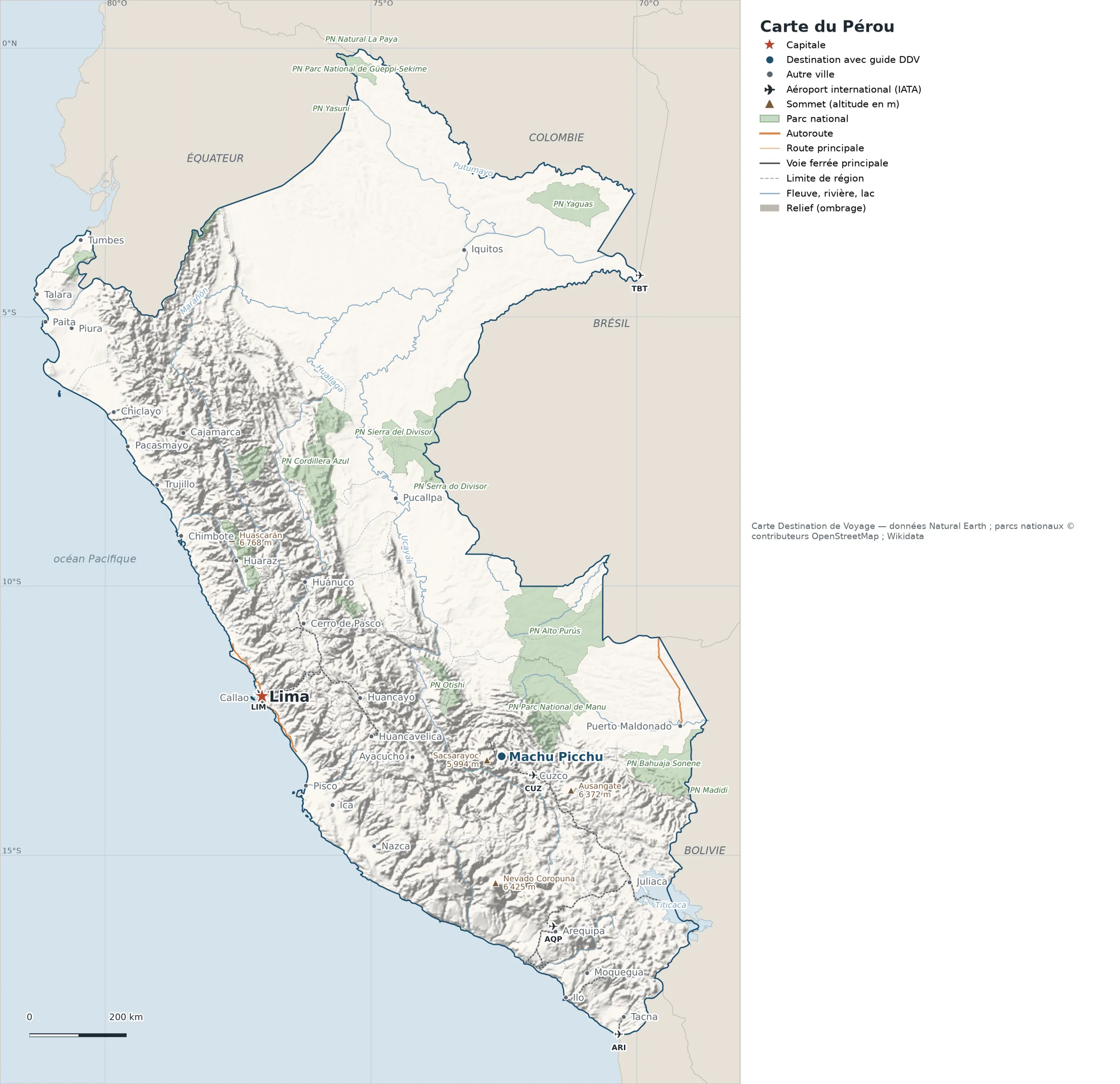
This map of Peru shows the capital, Lima, the destination covered in our guides and the main cities, with terrain, national parks, expressways, railways, rivers and international airports.
Neighbouring countries (land border): Bolivia, Brazil, Chile, Colombia and Ecuador. Its coasts border the Gulf of Guayaquil and the Pacific Ocean.

Our travel deals for Map
Affiliate links: we earn a commission, at no extra cost to you.
 FlightsKiwi.comCompare flights and airline combinations to Map.Compare flights
- eSIMSailyAnother eSIM plan to compare: data, validity, network.See Saily plans


Open the full-size map (high resolution, zoomable)
Key: red star = capital; blue dot = destination covered by a Destination de Voyage guide; blue italic name = region or island with a guide; grey dot = other city; plane = international airport (IATA code); brown triangle = summit (elevation); green areas = national parks (green square = national park shown as a point); thick orange line = expressway, light orange = main road; black-and-white line = main railway; grey dashes = regional boundaries; blue = rivers and lakes; shading = terrain; grid = latitude and longitude.
Sources: base map, cities, roads, railways, airports, administrative boundaries, rivers, lakes and hillshading: Natural Earth 1:10m (public domain). National parks: © OpenStreetMap contributors (ODbL licence) and Wikidata. Summits and elevations: Wikidata and Natural Earth. Places missing from Natural Earth: Wikipedia coordinates. Map produced by Destination de Voyage.
Regions and destinations on the map of Peru
| Region | Our guides | Other cities on the map |
|---|---|---|
| Cusco | Machu Picchu | Cusco |
| Ancash | — | Chimbote |
| Arequipa | — | Arequipa |
| Callao | — | Callao |
| Ica | — | Ica |
| Junín | — | Huancayo |
| La Libertad | — | Trujillo |
| Lambayeque | — | Chiclayo |
| Lima | — | Lima |
| Loreto | — | Iquitos |
| Piura | — | Piura |
| Puno | — | Juliaca |
| Tacna | — | Tacna |
| Ucayali | — | Pucallpa |
Straight-line distances between the main cities
Straight-line distances calculated from place coordinates (haversine formula). Actual journeys by road, rail, boat or plane are longer.
| Route | Straight-line distance |
|---|---|
| Lima – Machu Picchu | 505 km (314 mi) |
| Lima – Trujillo | 487 km (303 mi) |
| Lima – Cusco | 575 km (357 mi) |
| Lima – Tacna | 986 km (613 mi) |
| Lima – Ica | 267 km (166 mi) |
| Lima – Arequipa | 768 km (477 mi) |
| Lima – Iquitos | 1,013 km (629 mi) |
| Lima – Huancayo | 201 km (125 mi) |
Terrain, national parks and airports
Main summits (elevations from Wikidata / Natural Earth): Huascarán (6,768 m / 22,205 ft), Yerupajá (6,635 m / 21,768 ft), Nevado Coropuna (6,425 m / 21,079 ft), Ausangate (6,372 m / 20,906 ft), Huantsan (6,369 m / 20,896 ft).
National parks shown (19): Bahuaja Sonene National Park, Cordillera Azul National Park, Ichigkat muja – Cordillera del Cóndor National Park, Madidi National Park, Otishi National Park, Río Abiseo National Park, Tingo María National Park, Yanachaga Chemillén National Park, Güeppi-Sekime National Park, Huascarán National Park, Manu National Park, Alto Purús National Park, Cutervo National Park, Sierra del Divisor National Park, Cerros de Amotape National Park, Parque Nacional Natural La Paya, Parque Nacional Yasuní, Serra do Divisor National Park, Yaguas National Park.
International airports shown: ARI (Chacalluta), CUZ (Velazco Astete), TBT (Tabatinga), AQP (Rodríguez Ballón), LIM (Jorge Chávez).
Our guides by destination
Frequently asked questions
What is the capital of Peru?
Lima, marked by the red star on the map.
Which of our guide destinations is farthest from Lima?
Machu Picchu, about 505 km (314 mi) in a straight line (Destination de Voyage calculation).
Which countries border Peru?
Countries sharing a land border: Bolivia, Brazil, Chile, Colombia and Ecuador.
What is the highest summit shown on the map?
Huascarán, at 6,768 m (22,205 ft) elevation (source: Natural Earth).
Which international airports are on the map?
ARI (Chacalluta), CUZ (Velazco Astete), TBT (Tabatinga), AQP (Rodríguez Ballón), LIM (Jorge Chávez).