
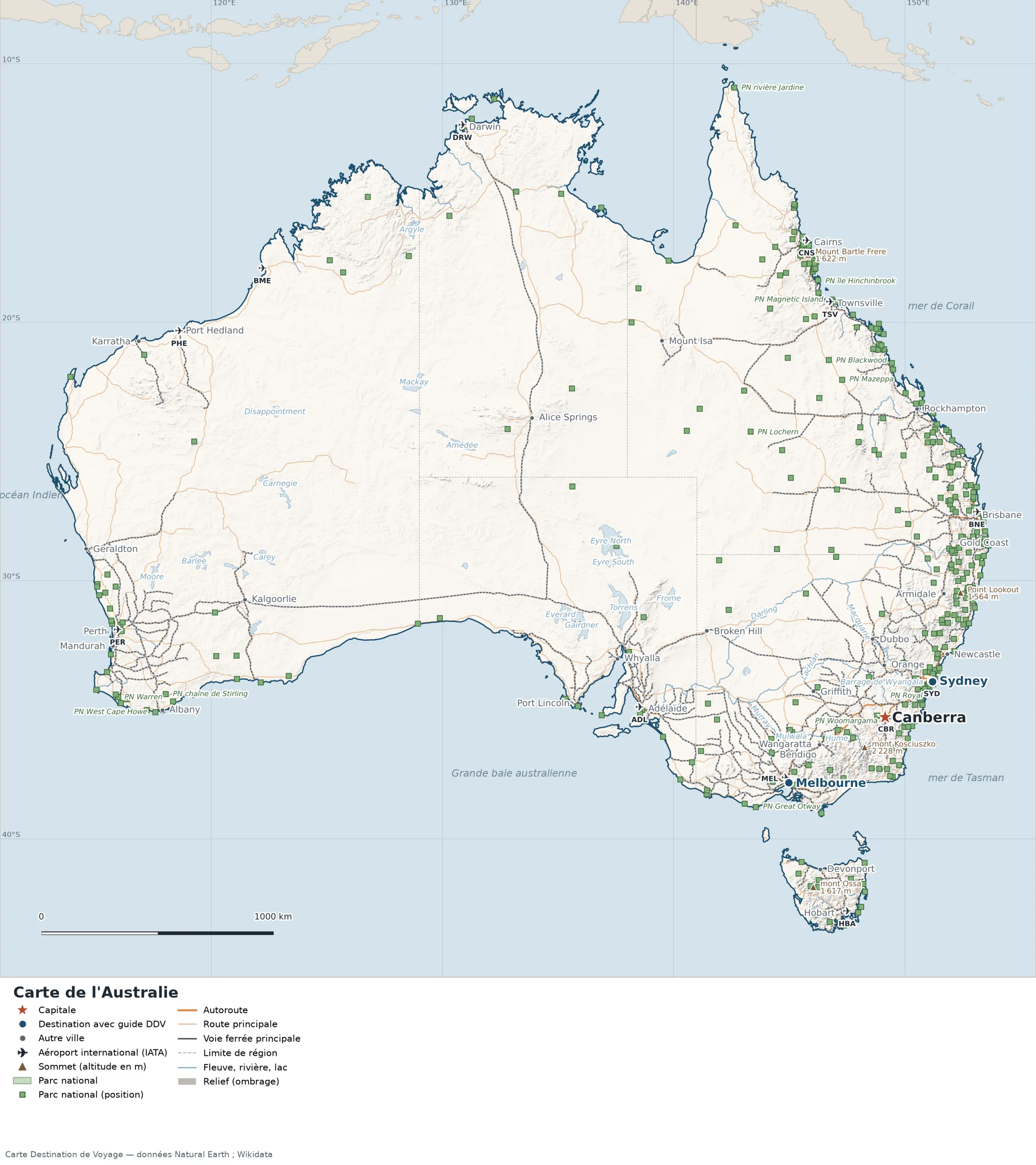
This map of Australia shows the capital, Canberra, the 2 destinations covered in our guides and the main cities, with terrain, national parks, expressways, railways, rivers and international airports.
Australia has no land border with another country on our base map. Its coasts face: Joseph Bonaparte Gulf, Gulf St Vincent, Gulf of Carpentaria, Great Australian Bight, Shark Bay and Geographe Bay.

Our travel deals for Map
Affiliate links: we earn a commission, at no extra cost to you.
 FlightsKiwi.comCompare flights and airline combinations to Map.Compare flights
- eSIMAiraloData plan to install before you leave (eSIM-compatible phone).See plans


Open the full-size map (high resolution, zoomable)
Key: red star = capital; blue dot = destination covered by a Destination de Voyage guide; blue italic name = region or island with a guide; grey dot = other city; plane = international airport (IATA code); brown triangle = summit (elevation); green areas = national parks (green square = national park located by a point); thick orange line = expressway, light orange = main road; black-and-white line = main railway; grey dashes = regional boundaries; blue = rivers and lakes; shading = terrain; grid = latitude and longitude.
Sources: base map, cities, roads, railways, airports, administrative boundaries, rivers, lakes and hillshading: Natural Earth 1:10m (public domain). National parks: Wikidata. Summits and elevations: Wikidata and Natural Earth. Places missing from Natural Earth: Wikipedia coordinates. Map produced by Destination de Voyage.
Regions and destinations on the map of Australia
| Region | Our guides | Other cities on the map |
|---|---|---|
| New South Wales | Sydney | Newcastle, Orange, Dubbo, Armidale |
| Victoria | Melbourne | Bendigo, Wangaratta, Portland, Geelong |
| South Australia | — | Adelaide |
| Western Australia | — | Perth |
| Queensland | — | Brisbane |
| Tasmania | — | Hobart |
| Australian Capital Territory | — | Canberra |
| Northern Territory | — | Darwin |
Straight-line distances between the main cities
Straight-line distances calculated from place coordinates (haversine formula). Actual journeys by road, rail, ferry or air are longer.
| Route | Straight-line distance |
|---|---|
| Canberra – Melbourne | 466 km (290 mi) |
| Canberra – Sydney | 242 km (150 mi) |
| Canberra – Perth | 3,090 km (1,920 mi) |
| Canberra – Brisbane | 946 km (588 mi) |
| Canberra – Adelaide | 958 km (595 mi) |
| Canberra – Newcastle | 367 km (228 mi) |
| Canberra – Townsville | 1,798 km (1,117 mi) |
| Canberra – Darwin | 3,136 km (1,949 mi) |
| Melbourne – Sydney | 708 km (440 mi) |
Terrain, national parks and airports
Main summits (elevations from Wikidata / Natural Earth): Mount Kosciuszko (2,228 m / 7,310 ft), Mount Jagungal (2,161 m / 7,090 ft), Mount Bogong (1,986 m / 6,516 ft), Mount Bimberi (1,912 m / 6,273 ft), Mount Buller (1,805 m / 5,922 ft).
National parks shown (340): the largest are labelled directly on the map.
International airports shown: HBA (Hobart), TSV (Townsville), BME (Broome), CNS (Cairns), PHE (Port Hedland), CBR (Canberra), ADL (Adelaide), BNE (Brisbane), DRW (Darwin), PER (Perth), MEL (Melbourne), SYD (Kingsford Smith).
Our guides by destination
Frequently asked questions
What is the capital of Australia?
Canberra, marked by the red star on the map.
Which of our guide destinations is farthest from Canberra?
Melbourne, about 466 km (290 mi) in a straight line (Destination de Voyage calculation).
What is the highest summit shown on the map?
Mount Kosciuszko, at an elevation of 2,228 m / 7,310 ft (source: Natural Earth).
Which international airports are on the map?
HBA (Hobart), TSV (Townsville), BME (Broome), CNS (Cairns), PHE (Port Hedland), CBR (Canberra), ADL (Adelaide), BNE (Brisbane), DRW (Darwin), PER (Perth), MEL (Melbourne), SYD (Kingsford Smith).