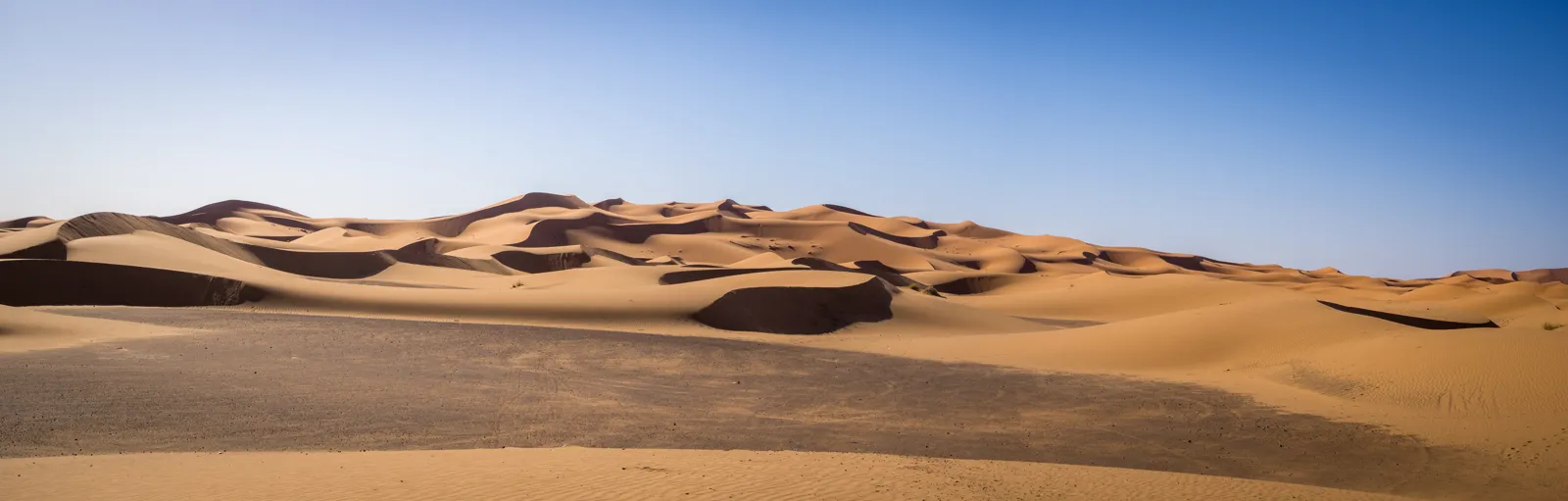
Visiting the Atacama Desert, in northern Chile, means basing yourself in the village of San Pedro de Atacama, at 2,407 m (7,897 ft): Valley of the Moon, altiplano lagoons, the salt flat and its flamingos, the El Tatio geysers at sunrise and some of the clearest skies in the world. This Atacama Desert travel guide suggests 4 to 5 days on site to see the main sights while getting used to the altitude. You can visit year-round; the most comfortable period runs from September to April, when the nights are less freezing.
It brings together the sites, opening hours and tickets published by CONAF, the climate, and two calculated figures other guides do not give: the number of hours of truly dark night each month, for stargazing, and the gap between day and night temperatures.

Our travel deals for Atacama Desert
Affiliate links: we earn a commission, at no extra cost to you.
 FlightsKiwi.comCompare flights and airline combinations to Atacama Desert.Compare flights
- eSIMSailyAnother eSIM plan to compare: data, validity, network.See Saily plans


Atacama Desert at a glance
- Country Chile, Antofagasta Region, El Loa Province
- Base San Pedro de Atacama2,407 m (7,897 ft) above sea level, 106 km (66 mi) southeast of Calama
- Language Spanish
- Currency Chilean peso (CLP); cash is useful in the village · currencies
- Time zone Chile changes its clocks on different dates from Europe and North America · detailsLocal time now: –:–
- Airports Santiago international airport, then a domestic flight to Calama (El Loa Airport) and the road to San Pedro
- Entry US and UK citizens: no visa for tourist stays of up to 90 days · travel.state.gov · GOV.UK
- Electricity 220 V, 50 Hz, type C and L plugs (round pins) · plugsUS and UK travelers need an adapter; US devices must accept 220 V
- Altitude excursions above 4,000 m (13,123 ft)Miscanti lagoon, 4,140 m (13,583 ft); El Tatio geysers, 4,320 m (14,173 ft)
What to see in the Atacama Desert: the highlights
Valley of the Moon (Valle de la Luna)
A few kilometers from San Pedro, this sector of the Los Flamencos National Reserve is a landscape of dunes, salt ridges and wind-carved formations. You can visit by car, by bike or on a tour, often late in the day for the sunset. According to the official CONAF site (checked 26 October 2026), tickets must be bought at least one day in advance on valledelaluna.com, and you cannot enter on foot. Hours are 9 am to 5 pm from September to March and 8 am to 4 pm from April to the first week of September, with shorter slots for cyclists. The sector closes on some staff-training days (for example the Tuesdays of October 2026): check before you go.
El Tatio geysers
At 4,320 m (14,173 ft), El Tatio is one of the largest geyser fields in the Southern Hemisphere. The steam columns are most impressive at sunrise, when the air is coldest, so tours leave San Pedro in the middle of the night. It is often below freezing at that hour: bring gloves, a hat and several layers.
Miscanti and Miñiques altiplano lagoons
Two deep-blue lagoons at the foot of the volcanoes, Miscanti at 4,140 m (13,583 ft), in another sector of the Los Flamencos reserve. According to CONAF (checked 26 October 2026), visits are booked on socairechile.cl, with a mandatory check-in in the village of Socaire; open 9 am to 5 pm. They are often combined with Chaxa lagoon.
Salar de Atacama and Chaxa lagoon
South of San Pedro, the vast salt flat is home to Chaxa lagoon (Soncor sector of the reserve), where flamingos feed. CONAF (checked 26 October 2026) lists tickets sold through the Ckapin Ticket app, with hours of 8 am to 8 pm in summer (last entry 7 pm) and 7 am to 7 pm in winter (last entry 6 pm), which the Toconao community may change.
San Pedro village and Tulor
Adobe houses, a white church and dirt streets: San Pedro is the base for every excursion. Nearby, the archaeological village of Tulor, also in the reserve, is open Monday to Friday, with booking by email according to CONAF.
Stargazing
Dry air, altitude and little light pollution make the desert one of the world’s great astronomy regions. Several operators in San Pedro run evening sessions with telescopes. The ALMA observatory, however, stated on its website (checked 15 October 2026) that its public visit program is currently suspended and reserved for educational institutions and media.
The flowering desert
In some years of exceptional rain, the desert is covered in flowers between September and November: the « desierto florido ». It mostly happens further south, between Vallenar and Copiapó in the Atacama Region, several hundred kilometers from San Pedro. It cannot be predicted in advance: follow the news that year.
How many days in the Atacama Desert?
High-altitude trips call for a set order: start with the lower sites and finish with the highest. A sample 4-day plan:
- Day 1: arrive in Calama, transfer to San Pedro (2,407 m / 7,897 ft), village and rest; Valley of the Moon at sunset if you feel well.
- Day 2: Salar de Atacama and Chaxa lagoon, then the Miscanti and Miñiques lagoons (above 4,000 m / 13,123 ft).
- Day 3: night departure for the El Tatio geysers (4,320 m / 14,173 ft); quiet afternoon; stargazing in the evening.
- Day 4: Tulor or a bike ride around the village, then back to Calama.
This pace follows the usual advice to climb gradually, drink plenty of water and avoid alcohol; the UK FCDO (GOV.UK, updated 9 October 2026) notes that altitude sickness is a risk in parts of Chile. For a wider trip (Santiago, the lakes, Patagonia), see our Chile travel guide. Many travelers continue to Sud Lípez and the Uyuni salt flat in Bolivia.
When to go to the Atacama Desert
The desert can be visited year-round. Afternoons reach 19 to 28 °C (66 to 82 °F) in San Pedro, but nights drop below freezing in June and July, and much lower at altitude, at the geysers or on the altiplano. It almost never rains: only February gets around 20 mm (0.8 in), from the altiplano summer storms (« Bolivian winter »), which can close high roads. April-May and September-November combine milder nights, dry skies and fewer visitors than January-February, the Chilean summer holidays.
| Month | High °C (°F) | Low °C (°F) | Day/night gap (°C) | Rain mm (in) | Dark night (h) | Sunset | Verdict |
|---|---|---|---|---|---|---|---|
| January | 28.0 (82) | 8.8 (48) | 19.2 | 4 (0.2) | 7.8 | 8:23 pm | ⚠️ Hot, Chilean holidays |
| February | 28.0 (82) | 9.4 (49) | 18.6 | 21 (0.8) | 8.5 | 8:12 pm | ⚠️ Possible storms at altitude |
| March | 27.0 (81) | 7.9 (46) | 19.1 | 7 (0.3) | 9.2 | 7:48 pm | ✅ Mild, dry skies |
| April | 25.0 (77) | 5.1 (41) | 19.9 | 0 (0.0) | 10.0 | 6:19 pm | ✅ Ideal |
| May | 21.8 (71) | 1.9 (35) | 19.9 | 1 (0.0) | 10.4 | 5:59 pm | ✅ Cool nights, clear skies |
| June | 18.9 (66) | −0.5 (31) | 19.4 | 2 (0.1) | 10.6 | 5:55 pm | ⚠️ Freezing nights |
| July | 19.3 (67) | −0.8 (31) | 20.1 | 0 (0.0) | 10.5 | 6:04 pm | ⚠️ Freezing nights, winter holidays |
| August | 21.5 (71) | 0.9 (34) | 20.6 | 1 (0.0) | 10.2 | 6:16 pm | ✅ Cool, very clear skies |
| September | 23.4 (74) | 2.7 (37) | 20.7 | 1 (0.0) | 9.5 | 7:26 pm | ✅ Ideal |
| October | 25.7 (78) | 4.4 (40) | 21.3 | 0 (0.0) | 8.8 | 7:36 pm | ✅ Ideal |
| November | 27.3 (81) | 5.8 (42) | 21.5 | 1 (0.0) | 8.0 | 7:53 pm | ✅ Mild |
| December | 28.0 (82) | 7.3 (45) | 20.7 | 0 (0.0) | 7.6 | 8:13 pm | ⚠️ Hot, end-of-year holidays |
How to read it: for astronomy, June offers about 10.6 hours of dark night, against 7.6 in December, so the southern winter is the best season for stargazing, if you can handle the cold. Also think about the Moon: an observation evening is richer around the new moon. The gap between day and night is about 19 to 21 °C (34 to 38 °F) all year: dress in layers.
In Calama, the air gateway, the Dirección Meteorológica de Chile records average highs of 21 to 25 °C (70 to 77 °F) all year and never more than 1.4 mm (0.1 in) of rain a month (1991-2020 normals). To compare with Santiago and Patagonia, see when to go to Chile.
Budget for the Atacama Desert
San Pedro is one of the most expensive stops in Chile, because almost everything is done on tours. Domestic flights add to the budget. Entry fees published by CONAF, checked on 26 October 2026:
| Site | Entry fee published by CONAF | Booking |
|---|---|---|
| Valley of the Moon | CLP 10,800 general rate; CLP 5,400 seniors and students | Online, at least the day before (valledelaluna.com) |
| Miscanti and Miñiques lagoons | CLP 4,000 to 8,000 for foreign visitors depending on age | socairechile.cl, then check-in at Socaire |
| Chaxa lagoon (salt flat) | Not shown on the CONAF page | Ckapin Ticket app |
| Tulor | Not shown on the CONAF page | By email |
Add the Calama-San Pedro transfer, tours (often paid in cash, entry fees sometimes not included) and accommodation. To convert pesos, use our currency converter.
Getting around the Atacama Desert
- Getting there: flights from Santiago to Calama (LATAM, Sky Airline, JetSmart), then a bus or transfer to San Pedro (106 km / 66 mi).
- Tours: the easiest option for El Tatio (night departure) and the high lagoons; check whether entry fees are included.
- Rental car: gives you freedom (the Valley of the Moon cannot be entered on foot, according to CONAF). Drive carefully on high-altitude roads, where altitude sickness can affect your concentration.
- Bike: handy for the Valley of the Moon and around the village, with time slots reserved for cyclists according to CONAF.
- Landmines: according to the UK FCDO (GOV.UK, updated 9 October 2026), most minefields are near the borders with Peru and Bolivia in the far north of Chile (regions XV, I and II), and some signs and fences are old and hard to spot. The U.S. Department of State advises following clearly identified roads and trails: never leave them.
Where to stay in the Atacama Desert
| Area | Best for | Highlights |
|---|---|---|
| Central San Pedro | Budget travelers, no car | Everything on foot, agencies and restaurants, tour departures |
| Ayllus around the village | Couples, a quiet stay | Lodges and guesthouses, darker skies for stargazing; a car or bike is useful |
| Calama | Late arrival or early departure | Close to the airport; little tourist interest |
Entry requirements, health and safety
- US citizens: according to the U.S. Department of State (travel.state.gov, last updated July 2, 2026), you do not need a visa for a tourist or business stay of 90 days or fewer. Your passport must be in good condition and valid for your stay. On arrival you receive a Tourist Card (Tarjeta de Turismo), which you must return on departure.
- UK citizens: according to the UK FCDO (GOV.UK, updated 9 October 2026), you can visit Chile for up to 90 days without a visa. Your passport should expire after the day you plan to leave Chile. Keep the tourist card you receive on arrival and hand it back when you leave.
- Minors: children traveling without one or both parents need a notarized authorization from the non-traveling parent(s) and an original birth certificate (both sources).
- Altitude: altitude sickness is a risk in parts of Chile (UK FCDO). San Pedro is at 2,407 m (7,897 ft) and several trips go above 4,000 m (13,123 ft): climb gradually and go back down if you have symptoms. Ask your doctor before traveling at high altitude with young children, during pregnancy or with a medical condition.
- Sun: protect yourself from heat and sun (clothing, sunscreen, water), especially at altitude.
- Vaccines: the UK FCDO advises checking the latest recommended vaccinations for Chile with a health professional before you go.
- Crime: according to the U.S. Department of State, street crime is common in several cities including Calama; keep all valuables on you on buses, especially to or from Calama and San Pedro de Atacama, where thefts are often carried out by people posing as bus employees.
- Volcanoes: the UK FCDO lists a continuing risk of eruptions at Láscar in northern Chile; follow local authority volcano monitoring advice, and climb volcanoes only with a professional guide.
- See our travel insurance guide.
Practical tips for the Atacama Desert
- Money: carry cash in pesos; cards are accepted in some places. Keep your card in sight when paying.
- Clothing: layers, a down jacket, gloves and a hat for El Tatio and the evenings; sunglasses and a hat during the day.
- Water: drink a lot, the air is very dry; limit alcohol for the first few days.
- Internet: decent coverage in the village, none on much of the high-altitude roads; download offline maps.
- Respect the sites: the Los Flamencos reserve is co-managed with Lickanantay communities: follow their access rules and stay on the trails.
Frequently asked questions
When is the best time to visit the Atacama Desert?
Year-round, with the best conditions in April-May and from September to November: nights less cold than in winter, little rain and fewer visitors than in January-February.
How many days do you need in San Pedro de Atacama?
Four to five days let you see the Valley of the Moon, the salt flat, the altiplano lagoons and the El Tatio geysers while getting used to the altitude gradually.
How do you get to the Atacama Desert?
Fly into Santiago, take a domestic flight to Calama, then drive or take a transfer 106 km (66 mi) to San Pedro de Atacama.
Do you need to book the Valley of the Moon?
Yes: according to CONAF, tickets must be bought at least one day in advance on valledelaluna.com.
When is the best time for stargazing in the Atacama Desert?
Year-round, but the southern winter has the longest dark nights (about 10.6 hours in June by our calculation, against 7.6 in December). Aim for dates close to the new moon.
Is altitude sickness a risk in the Atacama?
Yes: San Pedro is at 2,407 m (7,897 ft) and several trips go above 4,000 m (13,123 ft). Climb gradually, drink plenty of water and go back down if you have symptoms.
Our sources
- Atlas Agroclimático de Chile, San Pedro de Atacama station (temperatures 1958-1989, rainfall 1960-2015), via the Wikipedia article « San Pedro de Atacama »
- Dirección Meteorológica de Chile (DMC): 1991-2020 normals for the Calama station, taken from our when to go to Chile page
- Destination de Voyage calculations: astronomical night, sunset (NOAA solar algorithm) and day/night gap, for the coordinates of San Pedro de Atacama
- CONAF, Los Flamencos National Reserve: sectors, hours, tickets, co-management, checked 26 October 2026
- ALMA Observatory (almaobservatory.org): visits page, checked 15 October 2026
- U.S. Department of State, Chile country information (travel.state.gov, last updated July 2, 2026), read on 26 October 2026
- UK FCDO, foreign travel advice for Chile (GOV.UK, updated 9 October 2026), read on 26 October 2026
- Wikipedia: « San Pedro de Atacama » (altitude, distance from Calama), « El Tatio » and « Laguna Miscanti » (altitudes), « Desert bloom », « El Loa Airport » (domestic flights)
- Our methodology
Updated October 2026.
To plan the rest of your trip, see our Chile travel guide, our when to go to Chile page, our tips for Patagonia and our other destinations in Latin America.