Oaxaca de Juárez, often simply called Oaxaca, is the capital of the state of the same name in southern Mexico. It sits in a valley of the Sierra Madre del Sur at about 1,550 m (5,100 ft) above sea level, and its historic center has been a UNESCO World Heritage Site since 1987, together with the nearby Zapotec site of Monte Albán. Visiting Oaxaca means walking the colonial streets around the Zócalo and Santo Domingo, eating in the markets, climbing up to Monte Albán and branching out to Mitla, Hierve el Agua and the craft villages of the central valleys. Here is what to see, when to come according to the official normals of Mexico’s weather service, how to get there and what the US and UK governments say.
Best timesOctober–November and December–March, the dry season; from June to September it rains on about one day in three or more
Time zoneUTC−6 all year (central Mexico no longer changes its clocks): 6 hours behind London in winter (7 hours during UK summer time), 1 hour behind New York in winter (see time difference in Mexico)
Altitudeabout 1,550 m (5,100 ft): hot days, cool nights in winter (a low of 10 °C (50 °F) in January)
Entryno visa for tourism for US and UK citizens; the length of stay is set on arrival (travel.state.gov, GOV.UK)
Safetythe State Department rates Mexico Level 2; the FCDO reports protests that have blocked access to Oaxaca airport and notes earthquake risk, particularly in Oaxaca state
HighlightsZócalo, Santo Domingo, markets, Monte Albán, Mitla, Hierve el Agua
What to see in Oaxaca: the highlights
The Zócalo and the cathedral
The Plaza de la Constitución, or Zócalo, was laid out in 1529. Its bandstand replaced a marble fountain in 1857, and a statue of Benito Juárez, who was born in the region, was added in 1885. The square is lined by the cathedral and the former state government palace; to the northwest, the Alameda de León extends the square with a garden. It is the natural starting point for any visit, and the venue for the city’s big gatherings.
Santo Domingo de Guzmán and the cultural center
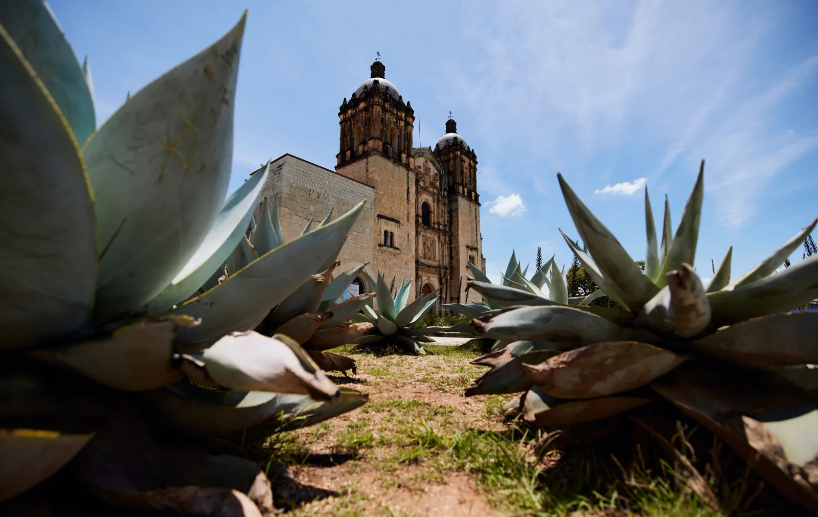
The church and former convent of Santo Domingo, four blocks north of the cathedral, were built between 1555 and 1666. The former convent buildings, restored in 1996, house the Santo Domingo Cultural Center, which displays objects found at Monte Albán among other things. Behind it, the ethnobotanical garden occupies the former convent gardens and presents the flora of the state, including many cacti and agaves.
Santo Domingo de Guzmán and its ethnobotanical garden of agaves
The Macedonio Alcalá pedestrian street and the museums
Macedonio Alcalá street, paved in green stone (cantera) and pedestrian since 1985, links the Zócalo to Santo Domingo. On it you find the Museum of Contemporary Art (MACO), housed in the « House of Cortés », one of the oldest civil buildings in the city. The Rufino Tamayo Museum displays the collection of pre-Hispanic art assembled by the painter, which he donated to his native state in 1974. The Macedonio Alcalá Theater, built between 1903 and 1909, is still in use.
The Benito Juárez and 20 de Noviembre markets
Just south of the Zócalo, the Benito Juárez market fills an entire block: flowers, fruit, drinks, crafts, leather, hats, knives. The next block holds the 20 de Noviembre market, nicknamed the « food market », where you eat on the spot. Oaxaca is famous for its moles, complex sauces based on chiles and sometimes chocolate: this is where to taste them, along with tlayudas.
Monte Albán
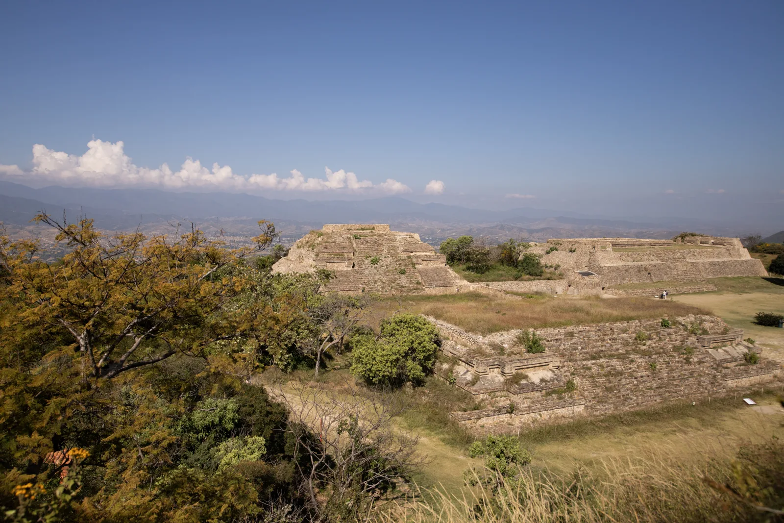
On a hill overlooking the valley, Monte Albán was a capital of the Zapotecs; it flourished between 500 BC and AD 800 and is thought to have had about 35,000 inhabitants. You see vast platforms, carved stones and a large central esplanade. The site has been a World Heritage Site with the city since 1987. Come early: there is little shade, and an April afternoon averages above 34 °C (93 °F) in the valley.
Monte Albán, the former Zapotec capital above the valley
Mitla, Hierve el Agua and the central valleys
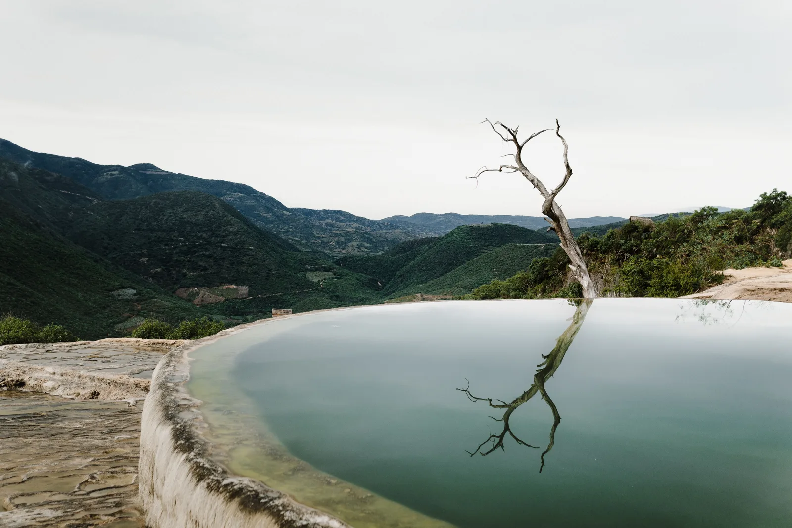
Mitla, southeast of Oaxaca, is a Zapotec then Mixtec city known for its stone fret mosaics: the « Patio of the Frets » of the Group of the Columns is said to have nearly 100,000 pieces. Farther on, Hierve el Agua has two « petrified waterfalls », formed by mineral deposits from springs, and pools where you can swim. The track that leads there starts from Mitla; colectivos leave only when full, hence the appeal of an organized excursion or an early start. The central valleys also have craft villages and mezcal distilleries (palenques).
Day 1: Zócalo, cathedral, Benito Juárez and 20 de Noviembre markets, then Macedonio Alcalá street to Santo Domingo.
Day 2: Monte Albán at opening time, Santo Domingo Cultural Center and ethnobotanical garden in the afternoon.
Day 3: excursion to Mitla and Hierve el Agua, with a stop at a palenque or a craft village.
Day 4: Rufino Tamayo and MACO museums, the Jalatlaco district, sunset from Cerro del Fortín.
Festivals and events
The Guelaguetza, also called « Mondays on the Hill » (Lunes del Cerro), is the state’s big celebration of cultures, with dances and music from the different regions; it takes place notably at the Guelaguetza auditorium on Cerro del Fortín; check the dates of the edition on the state’s official site. The Night of the Radishes (Noche de Rábanos), in December, displays sculptures carved from large radishes on the Zócalo. The Day of the Dead period, in early November, is also very popular. The exact dates of the Guelaguetza change every year: check with the state tourist office before booking.
Where to stay in Oaxaca
The historic center, around the Zócalo and Santo Domingo, lets you do everything on foot. The former villages of Jalatlaco and Xochimilco, now neighborhoods of the city, are quieter. For the Guelaguetza, the Day of the Dead and the end of the year, book early. The former Santa Catalina convent became a hotel in 1976. In the dry season nights are cool: check that there are blankets, as heating is rare.
Getting to Oaxaca and getting around
Oaxaca-Xoxocotlán airport (OAX) is south of the city. Most flights go to Mexico City, for a connection; there are also routes to other Mexican cities and to US hubs. International visitors should therefore expect at least one connection; check routes on the airport and airline websites. Oaxaca is also linked to Mexico City and the rest of the country by long-distance coaches. The UK FCDO (GOV.UK, updated 20 October 2026) notes ongoing protests that have blocked vehicle access to Oaxaca airport: if you fly to Oaxaca, check the status of your flight, monitor local media and allow more time to get to and from the airport. In town, the center is explored on foot; taxis and colectivos serve the valley villages.
Transfer, excursion or car rental?
For Monte Albán, Mitla and Hierve el Agua, three options: an organized excursion (practical for Hierve el Agua), a taxi by the day or a rental car. Before booking, check what is included (entry fees, stops, return), the vehicle insurance and the route. The State Department advises complying with road checkpoints and, for US government employees, not traveling between cities after dark, a restriction it strongly advises US citizens to follow.
When to go to Oaxaca: climate month by month
Oaxaca has two clear seasons: a sunny dry season from November to April and a rainy season from May to October, with frequent afternoon showers. The altitude tempers the heat: it is hot by day all year and cool at night in winter. The table combines the official normals with our calculations.
Month
Avg. max
Avg. min
Rain
Rainy days
Day/night gap
Sunrise / sunset on the 15th
Day length
January
28.9 °C (84 °F)
10.3 °C (51 °F)
2 mm (0.1 in)
1.4
18.6 °C (33 °F)
6:59 am / 6:13 pm
11 h 13 min
February
31.1 °C (88 °F)
11.6 °C (53 °F)
5 mm (0.2 in)
1.1
19.5 °C (35 °F)
6:53 am / 6:28 pm
11 h 36 min
March
33.3 °C (92 °F)
13.6 °C (56 °F)
18 mm (0.7 in)
4.1
19.7 °C (35 °F)
6:34 am / 6:36 pm
12 h 02 min
April
34.9 °C (95 °F)
15.8 °C (60 °F)
47 mm (1.9 in)
7.6
19.1 °C (34 °F)
6:11 am / 6:42 pm
12 h 31 min
May
33.8 °C (93 °F)
16.7 °C (62 °F)
98 mm (3.9 in)
13.7
17.1 °C (31 °F)
5:55 am / 6:51 pm
12 h 56 min
June
30.9 °C (88 °F)
16.7 °C (62 °F)
188 mm (7.4 in)
19.9
14.2 °C (26 °F)
5:53 am / 7:01 pm
13 h 09 min
July
30.1 °C (86 °F)
15.9 °C (61 °F)
119 mm (4.7 in)
20.4
14.2 °C (26 °F)
6:01 am / 7:04 pm
13 h 03 min
August
30.0 °C (86 °F)
15.9 °C (61 °F)
132 mm (5.2 in)
20.5
14.1 °C (25 °F)
6:10 am / 6:52 pm
12 h 42 min
September
29.1 °C (84 °F)
16.1 °C (61 °F)
164 mm (6.5 in)
21.4
13.0 °C (23 °F)
6:15 am / 6:28 pm
12 h 14 min
October
29.3 °C (85 °F)
14.5 °C (58 °F)
63 mm (2.5 in)
12.0
14.8 °C (27 °F)
6:19 am / 6:05 pm
11 h 46 min
November
29.0 °C (84 °F)
12.3 °C (54 °F)
9 mm (0.4 in)
3.5
16.7 °C (30 °F)
6:31 am / 5:51 pm
11 h 20 min
December
28.9 °C (84 °F)
11.0 °C (52 °F)
9 mm (0.4 in)
2.4
17.9 °C (32 °F)
6:48 am / 5:55 pm
11 h 07 min
Temperatures, rainfall and number of rainy days: 1991–2020 climate normal for the Oaxaca station (20079, 1,594 m / 5,230 ft), Servicio Meteorológico Nacional (Conagua). Day/night gap, sunrise, sunset and day length: Destination de Voyage calculations (NOAA solar algorithm, 15th of each month, official central Mexico time).
Reading the table: from December to February it rains less than 10 mm (0.4 in) a month and the gap between day and night exceeds 18 °C (32 °F) (18.6 °C (33 °F) in January): T-shirt in the afternoon, sweater in the evening. April is the hottest month (34.9 °C (95 °F)). From June to September there are about 20 rainy days a month: plan visits for the morning. Destination de Voyage calculation: day length varies by only about 2 hours over the year (from 11 h 07 min in December to 13 h 09 min in June), as befits a tropical latitude.
Entry requirements, health and safety
US citizens: according to the U.S. Department of State (travel.state.gov, Mexico page last updated August 11, 2025), you need a passport book to enter Mexico by air (a passport card cannot be used to board a plane). Mexican authorities issue a digital entry permit (FMMD) at all 66 international airports and decide on arrival how long you may stay; a date stamp goes in your passport, and you may be directed through an e-gate that prints a receipt with a QR code. The Department rates Mexico Level 2, « Exercise increased caution », because of terrorism, crime and kidnapping (advisory updated May 28, 2026).
UK citizens: according to the UK FCDO (GOV.UK, updated 20 October 2026), your passport must be valid for the duration of your stay (the Mexican Embassy in the UK recommends at least 180 days, the longest tourist stay). Tourists do not need a visa and get a stamp in the passport with the number of days allowed. At border control you may be asked for a return or onward ticket, proof of accommodation and proof of sufficient funds; make sure you get your passport stamped on entry and exit. Tourists cannot do voluntary or paid work.
Both sources leave the length of stay to the immigration officer on arrival: check the number of days on your stamp or receipt.
Safety: neither the FCDO nor the State Department names the state of Oaxaca among the areas it advises against; check the State Department’s maps of restricted areas before any trip to the coast or the Isthmus. The FCDO notes that crime is a risk to foreign nationals, particularly in major cities and tourist resort areas, and that some genuine police officers have extorted money from tourists for alleged minor offences.
Earthquakes: the FCDO (GOV.UK, updated 20 October 2026) says there is a risk of earthquakes in most parts of Mexico, with tremors happening regularly, particularly in the states of Oaxaca and Guerrero; the State Department notes that Mexico is an active earthquake zone. Find the emergency instructions in your lodging.
Altitude: the FCDO says altitude sickness is a risk in parts of Mexico (see TravelHealthPro); at about 1,550 m (5,100 ft) Oaxaca is moderate, but take it easy on arrival.
Scams: the FCDO warns of a common phone scam in which criminals pose as a kidnapped family member and demand money; do not give personal information to unknown callers.
An eSIM installed before departure lets you use maps and transport apps on arrival, and stay in touch on excursions in the valleys. Check that your phone is compatible: see our travel eSIM guide. Our Mexico eSIM guide details networks and compatibility.
If you… then…
If you…
Then…
Want good weather
Come from November to March: less than 10 mm (0.4 in) of rain a month from November to February
Want to see the Guelaguetza
Come in July, in the rainy season, and book early; check the official dates
Visit Monte Albán
Arrive at opening time, with a hat and water: little shade on the site
Want Hierve el Agua without a car
Take an organized excursion, or leave early from Mitla by colectivo
Plan to reach the Pacific coast
Check the road conditions and the State Department’s restricted-area maps first
Feel the cold
Bring a sweater: the night drops to about 10 °C (50 °F) in January
Frequently asked questions
Is Oaxaca safe?
Neither the UK FCDO nor the U.S. Department of State names the state of Oaxaca among the areas it advises against (read 26 October 2026). The State Department rates Mexico Level 2, « Exercise increased caution », and the FCDO notes ongoing protests blocking vehicle access to Oaxaca airport.
What is the best time to visit Oaxaca?
The dry season, from November to March: less than 10 mm (0.4 in) of rain a month from November to February (SMN 1991–2020 normals). July attracts visitors for the Guelaguetza, despite the rain.
How many days should you spend in Oaxaca?
Three to four days: one or two for the city, one for Monte Albán, one for Mitla and Hierve el Agua.
Is it cold in Oaxaca?
Afternoons are hot all year (29 to 35 °C (84 to 95 °F) average high), but winter nights drop to about 10–11 °C (50–52 °F) because of the altitude.
How do you get to Oaxaca?
By plane, with at least one connection, most often in Mexico City, then a domestic flight; or by long-distance coach from Mexico City. Check the airport and airline websites for current routes.
Do you need a visa for Mexico?
No visa is needed for tourism for US or UK citizens; the number of days allowed is set on arrival and stamped in your passport (U.S. Department of State, last updated August 11, 2025; UK FCDO, GOV.UK, updated 20 October 2026).
Our sources
U.S. Department of State, Mexico country information (travel.state.gov, last updated August 11, 2025) and Mexico travel advisory (Level 2, updated May 28, 2026), read on 26 October 2026


 FlightsKiwi.comCompare flights and airline combinations to Oaxaca.Compare flights