
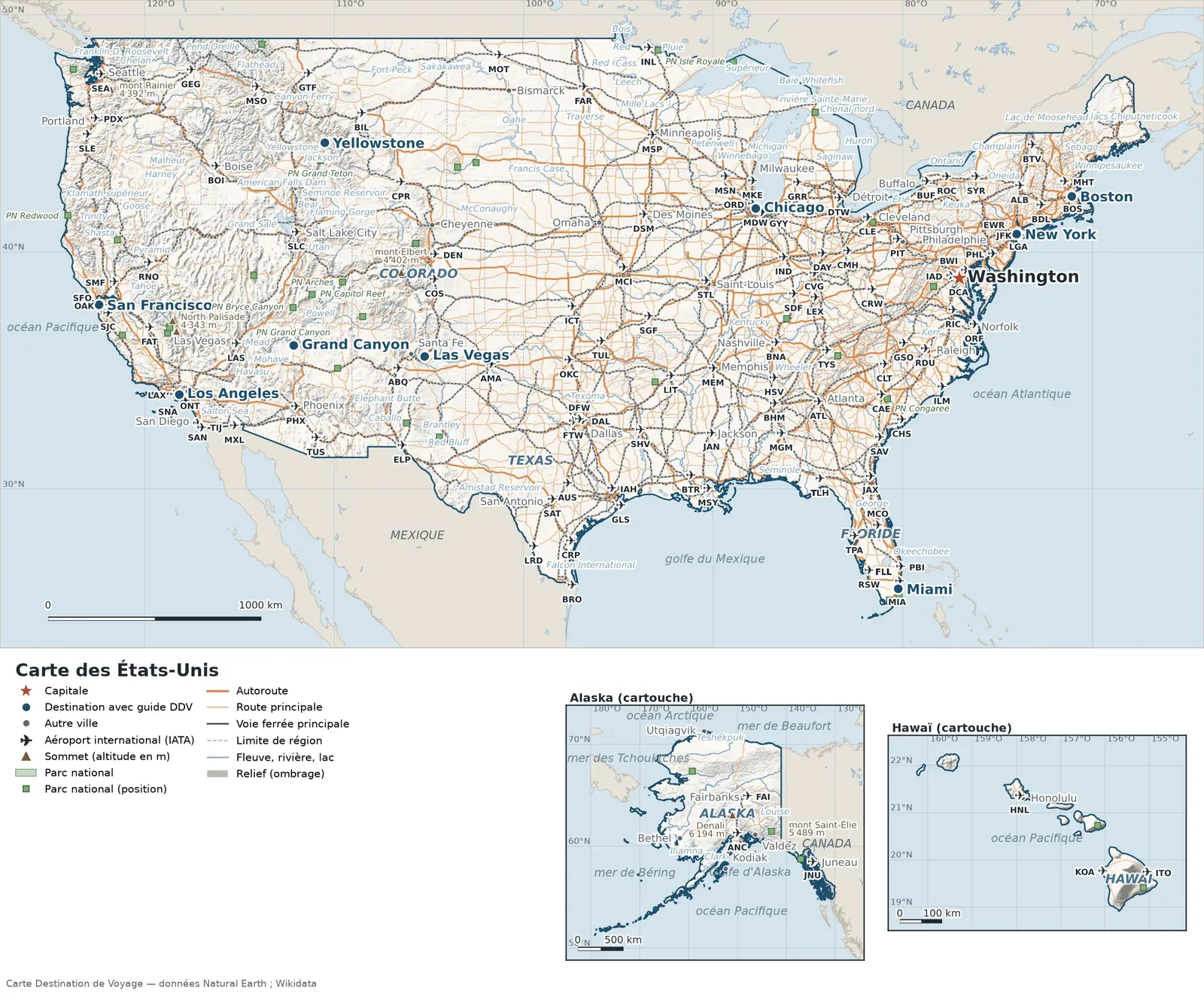
This map of the United States shows the capital, Washington, the 16 destinations covered in our guides and the main cities, with terrain, national parks, expressways, railways, rivers and international airports.
Neighbouring countries (land border): Canada and Mexico. Its coasts border Albemarle Bay, Baird Inlet, Cordova Bay, Dixon Entrance, the Gulf of Alaska and Cook Inlet. Remote territories (Alaska and Hawaii) appear in insets, each with its own scale.

Our travel deals for Map
Affiliate links: we earn a commission, at no extra cost to you.
 FlightsKiwi.comCompare flights and airline combinations to Map.Compare flights
- eSIMAiraloData plan to install before you leave (eSIM-compatible phone).See plans


Open the full-size map (high resolution, zoomable)
Key: red star = capital; blue dot = destination covered by a Destination de Voyage guide; blue italic name = region or island with a guide; grey dot = other city; plane = international airport (IATA code); brown triangle = summit (elevation); green areas = national parks (green square = national park shown as a point); thick orange line = expressway, light orange = main road; black-and-white line = main railway; grey dashes = regional boundaries; blue = rivers and lakes; shading = terrain; grid = latitude and longitude.
Sources: base map, cities, roads, railways, airports, administrative boundaries, rivers, lakes and hillshading: Natural Earth 1:10m (public domain). National parks: Wikidata. Summits and elevations: Wikidata and Natural Earth. Places missing from Natural Earth: Wikipedia coordinates. Map produced by Destination de Voyage.
Regions and destinations on the map of the United States
| Region | Our guides | Other cities on the map |
|---|---|---|
| Alaska | Alaska | Anchorage |
| Arizona | Grand Canyon | Phoenix |
| California | California and the West Coast, San Francisco, Los Angeles | San Diego, San José, Sacramento |
| Colorado | Colorado | Denver |
| Florida | Florida, Miami | Tampa |
| Hawaii | Hawaii | Honolulu |
| Illinois | Chicago | — |
| Massachusetts | Boston | — |
| Nevada | Las Vegas | — |
| Texas | Texas | Houston, Dallas, San Antonio |
| Washington | Washington | Seattle |
| Wyoming | Yellowstone | — |
| New York State | New York | Buffalo |
| Georgia | — | Atlanta |
Straight-line distances between the main cities
Straight-line distances calculated from place coordinates (haversine formula). Actual journeys by road, rail, boat or plane are longer.
| Route | Straight-line distance |
|---|---|
| Washington – San Francisco | 3,921 km (2,436 mi) |
| Washington – Los Angeles | 3,691 km (2,293 mi) |
| Washington – Grand Canyon | 3,097 km (1,924 mi) |
| Washington – Yellowstone | 2,828 km (1,757 mi) |
| Washington – Las Vegas | 2,514 km (1,562 mi) |
| Washington – Miami | 1,489 km (925 mi) |
| Washington – Chicago | 966 km (600 mi) |
| Washington – Boston | 630 km (391 mi) |
| Grand Canyon – Los Angeles | 596 km (370 mi) |
| Boston – New York | 299 km (186 mi) |
| Yellowstone – Grand Canyon | 960 km (597 mi) |
| Washington – New York | 331 km (206 mi) |
Terrain, national parks and airports
Main summits (elevations from Wikidata / Natural Earth): Denali (6,194 m / 20,322 ft), Mount Saint Elias (5,489 m / 18,009 ft), Mount Foraker (5,304 m / 17,402 ft), Mount Blackburn (4,996 m / 16,391 ft), Mount Bona (4,986 m / 16,358 ft).
National parks shown (44): the largest are labelled directly on the map.
International airports shown: AMA (Amarillo), BHM (Birmingham), BIL (Logan), BRO (Brownsville-South Padre Island), BTR (Baton Rouge Metro), BTV (Burlington), CAE (Columbia Metro), CHS (Charleston), CPR (Casper/Natrona County), CRW (Yeager), DAY (James M. Cox Dayton), DCA (Washington Nat’l), FAR (Hector), FAT (Fresno Yosemite), GEG (Spokane), GRR (Gerald R. Ford), GSO (Triad), GTF (Great Falls), HSV (Huntsville), ICT (Kansas City), ILM (Wilmington), INL (Falls), KOA (Kona at Keahole), LEX (Blue Grass), LIT (Clinton National), LRD (Laredo), MDW (Chicago Midway), MGM (Montgomery Reg.), MHT (Manchester-Boston Reg.), MOT (Minot), MSO (Missoula), MXL (Gen R.S. Taboada), RIC (Richmond), ROC (Greater Rochester), SGF (Springfield Reg.), SHV (Shreveport Reg.), SLE (McNary Field), TLH (Tallahassee Reg.), CRP (Corpus Christi), ELP (El Paso), FTW (Fort Worth Meacham Field), GLS (Scholes), GYY (Gary/Chicago), IND (Indianapolis), OAK (Oakland), ONT (Ontario), RNO (Reno-Tahoe), TUS (Tucson), ABQ (Albuquerque), BDL (Bradley), COS (City of Colorado Springs), CVG (Greater Cincinnati), DAL (Dallas Love Field), DSM (Des Moines), IAD (Dulles), ITO (Hilo), JAN (Jackson), JAX (Jacksonville), LGA (LaGuardia), MCI (Kansas City), OKC (Will Rogers), ORF (Norfolk), PBI (Palm Beach), PIT (Greater Pittsburgh), SAN (San Diego), SAT (San Antonio), SAV (Savannah), SMF (Sacramento), SYR (Syracuse Hancock), TUL (Tulsa), TYS (Mcghee Tyson), ALB (Albany), MKE (General Mitchell), AUS (Austin-Bergstrom), CMH (Port Columbus), JFK (John F Kennedy), MSN (Dane Cty. Reg. (Truax Field)), RSW (Southwest Florida), SJC (San Jose), SNA (John Wayne), SDF (Louisville), BNA (Nashville), BOI (Boise Air Terminal), BUF (Greater Buffalo), CLE (Hopkins), MEM (Memphis), MIA (Miami), MSY (New Orleans), PDX (Portland), RDU (Durham), TIJ (General Abelardo L Rodriguez), TPA (Tampa), CLT (Douglas), DTW (Detroit Metro), FAI (Fairbanks), LAS (Mccarran), MCO (Orlando), MSP (Minneapolis St. Paul), PHL (Philadelphia), PHX (Sky Harbor), SLC (Salt Lake City), STL (Lambert St Louis), ANC (Anchorage), ATL (Hartsfield-Jackson Atlanta), BOS (Gen E L Logan), BWI (Baltimore-Washington Thurgood Marshall), DEN (Denver), DFW (Dallas-Ft. Worth), EWR (Newark), FLL (Fort Lauderdale Hollywood), IAH (George Bush Intercontinental), JNU (Juneau), LAX (Los Angeles), HNL (Honolulu), ORD (Chicago O’Hare), SEA (Seattle-Tacoma), SFO (San Francisco).
Our guides by destination
- Alaska
- Boston
- California and the West Coast
- Chicago
- Colorado
- Florida
- Grand Canyon
- Hawaii
- Las Vegas
- Los Angeles
- Miami
- New York
- San Francisco
- Texas
- Washington
- Yellowstone
- All our travel advice: United States
Frequently asked questions
What is the capital of the United States?
Washington, marked by the red star on the map.
Which of our guide destinations is farthest from Washington?
San Francisco, about 3,921 km (2,436 mi) in a straight line (Destination de Voyage calculation).
Which countries border the United States?
Countries sharing a land border: Canada and Mexico.
What is the highest summit shown on the map?
Denali, at 6,194 m (20,322 ft) elevation (source: Natural Earth).
Which international airports are on the map?
AMA (Amarillo), BHM (Birmingham), BIL (Logan), BRO (Brownsville-South Padre Island), BTR (Baton Rouge Metro), BTV (Burlington), CAE (Columbia Metro), CHS (Charleston), CPR (Casper/Natrona County), CRW (Yeager), DAY (James M. Cox Dayton), DCA (Washington Nat’l), FAR (Hector), FAT (Fresno Yosemite), GEG (Spokane), GRR (Gerald R. Ford), GSO (Triad), GTF (Great Falls), HSV (Huntsville), ICT (Kansas City), ILM (Wilmington), INL (Falls), KOA (Kona at Keahole), LEX (Blue Grass), LIT (Clinton National), LRD (Laredo), MDW (Chicago Midway), MGM (Montgomery Reg.), MHT (Manchester-Boston Reg.), MOT (Minot), MSO (Missoula), MXL (Gen R.S. Taboada), RIC (Richmond), ROC (Greater Rochester), SGF (Springfield Reg.), SHV (Shreveport Reg.), SLE (McNary Field), TLH (Tallahassee Reg.), CRP (Corpus Christi), ELP (El Paso), FTW (Fort Worth Meacham Field), GLS (Scholes), GYY (Gary/Chicago), IND (Indianapolis), OAK (Oakland), ONT (Ontario), RNO (Reno-Tahoe), TUS (Tucson), ABQ (Albuquerque), BDL (Bradley), COS (City of Colorado Springs), CVG (Greater Cincinnati), DAL (Dallas Love Field), DSM (Des Moines), IAD (Dulles), ITO (Hilo), JAN (Jackson), JAX (Jacksonville), LGA (LaGuardia), MCI (Kansas City), OKC (Will Rogers), ORF (Norfolk), PBI (Palm Beach), PIT (Greater Pittsburgh), SAN (San Diego), SAT (San Antonio), SAV (Savannah), SMF (Sacramento), SYR (Syracuse Hancock), TUL (Tulsa), TYS (Mcghee Tyson), ALB (Albany), MKE (General Mitchell), AUS (Austin-Bergstrom), CMH (Port Columbus), JFK (John F Kennedy), MSN (Dane Cty. Reg. (Truax Field)), RSW (Southwest Florida), SJC (San Jose), SNA (John Wayne), SDF (Louisville), BNA (Nashville), BOI (Boise Air Terminal), BUF (Greater Buffalo), CLE (Hopkins), MEM (Memphis), MIA (Miami), MSY (New Orleans), PDX (Portland), RDU (Durham), TIJ (General Abelardo L Rodriguez), TPA (Tampa), CLT (Douglas), DTW (Detroit Metro), FAI (Fairbanks), LAS (Mccarran), MCO (Orlando), MSP (Minneapolis St. Paul), PHL (Philadelphia), PHX (Sky Harbor), SLC (Salt Lake City), STL (Lambert St Louis), ANC (Anchorage), ATL (Hartsfield-Jackson Atlanta), BOS (Gen E L Logan), BWI (Baltimore-Washington Thurgood Marshall), DEN (Denver), DFW (Dallas-Ft. Worth), EWR (Newark), FLL (Fort Lauderdale Hollywood), IAH (George Bush Intercontinental), JNU (Juneau), LAX (Los Angeles), HNL (Honolulu), ORD (Chicago O’Hare), SEA (Seattle-Tacoma), SFO (San Francisco).
Why are some islands shown in an inset?
They are too far from the main territory to fit on the same scale: Alaska and Hawaii are shown separately, with their own scale.