
This map of Spain shows the capital, Madrid, the 12 destinations covered in our guides and the main cities, with terrain, national parks, expressways, railways, rivers and international airports.
Neighbouring countries (land border): Andorra, France, Gibraltar, Morocco and Portugal. Its coasts border the Gulf of Lion, the Strait of Gibraltar, the Bay of Biscay, the Mediterranean Sea, the Alboran Sea and the Balearic Sea. Remote territories (Canary Islands) appear in insets, each with its own scale.

Our travel deals for Map
Affiliate links: we earn a commission, at no extra cost to you.
 FlightsKiwi.comCompare flights and airline combinations to Map.Compare flights

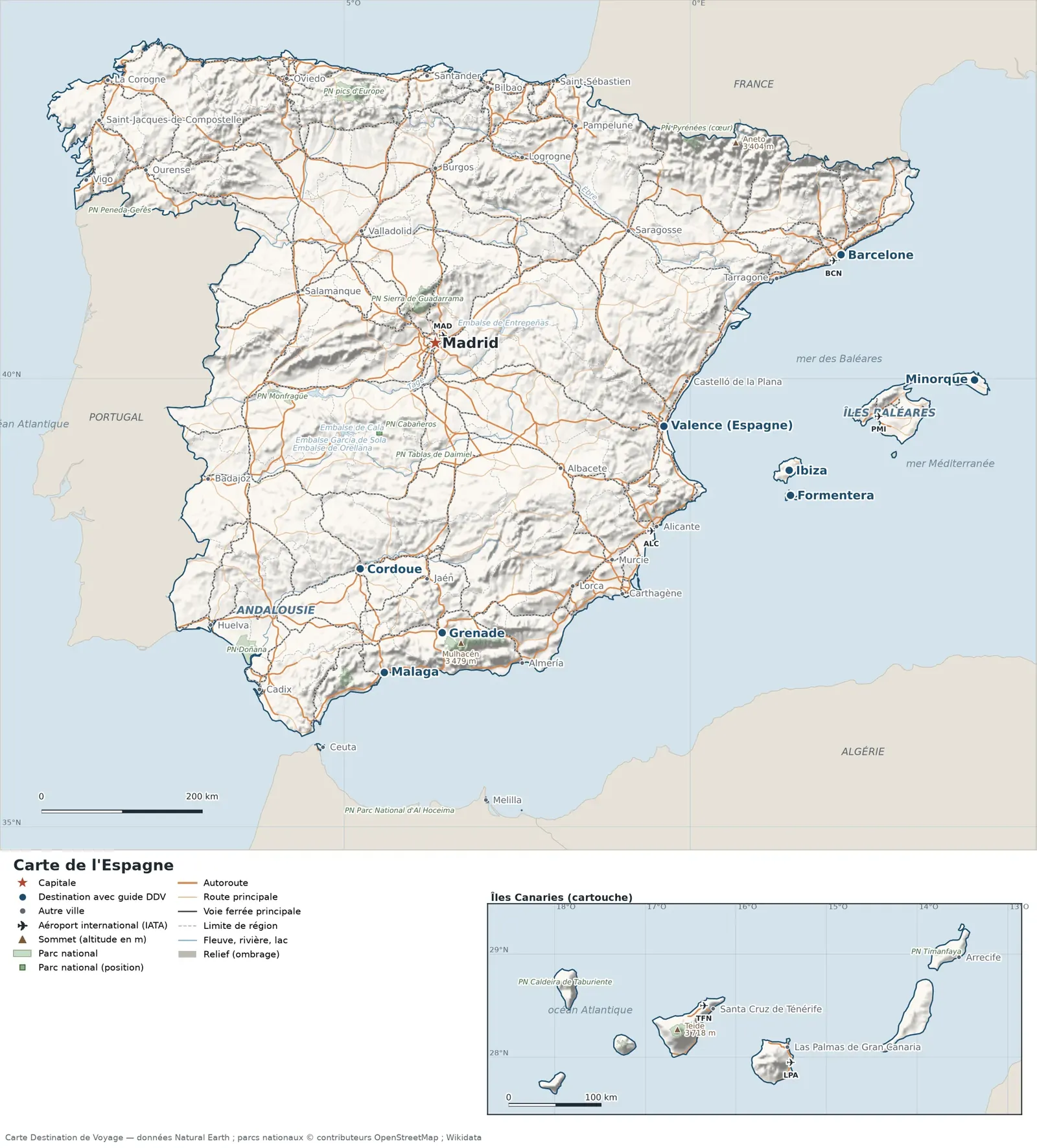
Open the full-size map (high resolution, zoomable)
Key: red star = capital; blue dot = destination covered by a Destination de Voyage guide; blue italic name = region or island with a guide; grey dot = other city; plane = international airport (IATA code); brown triangle = summit (elevation); green areas = national parks (green square = national park shown as a point); thick orange line = expressway, light orange = main road; black-and-white line = main railway; grey dashes = regional boundaries; blue = rivers and lakes; shading = terrain; grid = latitude and longitude.
Sources: base map, cities, roads, railways, airports, administrative boundaries, rivers, lakes and hillshading: Natural Earth 1:10m (public domain). National parks: © OpenStreetMap contributors (ODbL licence) and Wikidata. Summits and elevations: Wikidata and Natural Earth. Places missing from Natural Earth: Wikipedia coordinates. Map produced by Destination de Voyage.
Regions and destinations on the map of Spain
| Region | Our guides | Other cities on the map |
|---|---|---|
| Barcelona | Barcelona | — |
| Community of Madrid | Madrid | — |
| Córdoba | Córdoba | — |
| Granada | Granada | — |
| Málaga | Malaga | — |
| Seville | Andalusia | — |
| Valencia | Valencia (Spain) | — |
| Balearic Islands | Balearic Islands, Formentera, Menorca, Ibiza, Mallorca | Palma de Mallorca |
| Biscay | — | Bilbao |
| A Coruña | — | A Coruña |
| Las Palmas | — | Las Palmas de Gran Canaria |
| Murcia | — | Murcia |
| Pontevedra | — | Vigo |
| Zaragoza | — | Zaragoza |
Straight-line distances between the main cities
Straight-line distances calculated from place coordinates (haversine formula). Actual journeys by road, rail, boat or plane are longer.
| Route | Straight-line distance |
|---|---|
| Madrid – Menorca | 664 km (413 mi) |
| Madrid – Barcelona | 505 km (314 mi) |
| Madrid – Formentera | 479 km (298 mi) |
| Madrid – Ibiza | 465 km (289 mi) |
| Madrid – Malaga | 414 km (257 mi) |
| Madrid – Granada | 360 km (224 mi) |
| Madrid – Valencia (Spain) | 300 km (186 mi) |
| Madrid – Córdoba | 296 km (184 mi) |
| Valencia (Spain) – Ibiza | 165 km (103 mi) |
| Barcelona – Menorca | 225 km (140 mi) |
| Granada – Malaga | 89 km (55 mi) |
| Formentera – Ibiza | 31 km (19 mi) |
Terrain, national parks and airports
Main summits (elevations from Wikidata / Natural Earth): Teide (3,718 m / 12,198 ft), Mulhacén (3,479 m / 11,414 ft), Aneto (3,404 m / 11,168 ft), Monte Perdido (3,355 m / 11,007 ft), Frondella (3,071 m / 10,075 ft).
National parks shown (17): Doñana National Park, Al Hoceima National Park, Ordesa y Monte Perdido National Park, Garajonay National Park, Timanfaya National Park, Cabrera Archipelago National Park, Caldera de Taburiente National Park, Pyrenees National Park (core), Tablas de Daimiel National Park, Picos de Europa National Park, Teide National Park, Monfragüe National Park, Sierra Nevada National Park, Sierra de Guadarrama National Park, Peneda-Gerês National Park, Sierra de las Nieves National Park, Cabañeros National Park.
International airports shown: ALC (Alicante), LPA (Gran Canaria), PMI (Palma de Mallorca), TFN (Tenerife N.), BCN (Barcelona), MAD (Madrid Barajas).
Our guides by destination
- Andalusia
- Barcelona
- Córdoba
- Formentera
- Granada
- Ibiza
- Madrid
- Mallorca
- Malaga
- Menorca
- Valencia (Spain)
- Balearic Islands
- All our travel advice: Spain
- Our methodology
Frequently asked questions
What is the capital of Spain?
Madrid, marked by the red star on the map.
Which of our guide destinations is farthest from Madrid?
Menorca, about 664 km (413 mi) in a straight line (Destination de Voyage calculation).
Which countries border Spain?
Countries sharing a land border: Andorra, France, Gibraltar, Morocco and Portugal.
What is the highest summit shown on the map?
Teide, at 3,718 m (12,198 ft) elevation (source: Natural Earth).
Which international airports are on the map?
ALC (Alicante), LPA (Gran Canaria), PMI (Palma de Mallorca), TFN (Tenerife N.), BCN (Barcelona), MAD (Madrid Barajas).
Why are some islands shown in an inset?
They are too far from the main territory to fit on the same scale: the Canary Islands are shown separately, with their own scale.