
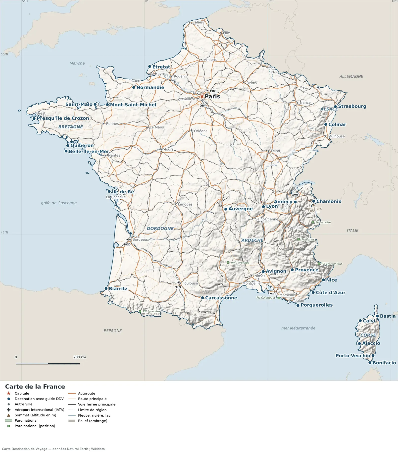
This map of France shows the capital, Paris, the 32 destinations covered in our guides and the main cities, with terrain, national parks, expressways, railways, rivers and international airports.
Countries sharing a land border: Germany, Andorra, Belgium, Spain, Italy, Luxembourg, Monaco and Switzerland. Its coastline faces: Gulf of Lion, English Channel, Mozambique Channel, Bay of Biscay, Ligurian Sea and Mediterranean Sea.

Our travel deals for Map
Affiliate links: we earn a commission, at no extra cost to you.
 FlightsKiwi.comCompare flights and airline combinations to Map.Compare flights

Open the full-size map (high resolution, zoomable)
Key: red star = capital; blue dot = destination covered by a Destination de Voyage guide; blue italic name = region or island with a guide; grey dot = other city; plane = international airport (IATA code); brown triangle = summit (elevation); green areas = national parks (green square = national park located by a single point); thick orange line = expressway, light orange = main road; black-and-white line = main railway; grey dashes = regional boundaries; blue = rivers and lakes; shading = terrain; grid = latitude and longitude.
Sources: base map, cities, roads, railways, airports, administrative boundaries, rivers, lakes and hillshading: Natural Earth 1:10m (public domain). National parks: Wikidata. Summits and elevations: Wikidata and Natural Earth. Places missing from Natural Earth: Wikipedia coordinates. Map produced by Destination de Voyage.
Regions and destinations on the map of France
| Region | Our guides | Other cities on the map |
|---|---|---|
| Alpes-Maritimes | Nice | — |
| Alpes-de-Haute-Provence | Provence | — |
| Ardèche | Ardèche | — |
| Aude | Carcassonne | — |
| Bas-Rhin | Alsace, Strasbourg | — |
| Calvados | Normandy | Caen |
| Charente-Maritime | Île de Ré | La Rochelle |
| Corse-du-Sud | Ajaccio, Bonifacio, Porto-Vecchio | — |
| Dordogne | Dordogne | — |
| Finistère | Crozon Peninsula | Brest |
| Haut-Rhin | Colmar | Mulhouse |
| Haute-Corse | Corsica, Bastia, Calvi | — |
| Haute-Savoie | Annecy, Chamonix | — |
| Ille-et-Vilaine | Saint-Malo | Rennes |
| English Channel | Mont-Saint-Michel | — |
| Morbihan | Brittany, Belle-Île-en-Mer, Quiberon | Lorient |
| Paris | Paris | — |
| Puy-de-Dôme | Auvergne | — |
| Pyrénées-Atlantiques | Biarritz | — |
| Rhône | Lyon | — |
| Seine-Maritime | Étretat | Le Havre, Rouen |
| Var | Côte d’Azur, Porquerolles | Toulon |
| Vaucluse | Avignon | — |
Straight-line distances between the main cities
Straight-line distances calculated from the coordinates of the places (haversine formula). Actual journeys by road, rail, ferry or air are longer.
| Route | Straight-line distance |
|---|---|
| Paris – Bonifacio | 988 km (614 mi) |
| Paris – Porto-Vecchio | 974 km (605 mi) |
| Paris – Ajaccio | 919 km (571 mi) |
| Paris – Bastia | 879 km (546 mi) |
| Paris – Calvi | 859 km (534 mi) |
| Paris – Porquerolles | 718 km (446 mi) |
| Paris – Côte d’Azur | 704 km (437 mi) |
| Paris – Nice | 686 km (426 mi) |
| Paris – Étretat | 180 km (112 mi) |
| Annecy – Chamonix | 58 km (36 mi) |
| Île de Ré – Belle-Île-en-Mer | 183 km (114 mi) |
| Auvergne – Lyon | 119 km (74 mi) |
Terrain, national parks and airports
Main summits (elevations from Wikidata / Natural Earth): Mont Blanc (4,807 m / 15,771 ft), Barre des Écrins (4,102 m / 13,458 ft), Grande Casse (3,855 m / 12,648 ft).
National parks shown (8): La Réunion National Park, Guadeloupe National Park, Vanoise National Park, Calanques National Park, Cévennes National Park, Pyrénées National Park, Écrins National Park, Mercantour National Park.
International airports shown: BOD (Bordeaux), TLS (Toulouse-Blagnac), DZA (Dzaoudzi Pamanzi), MRS (Marseille Provence Airport), GVA (Geneva), ORY (Paris Orly), CDG (Charles de Gaulle).
Our guides by destination
- Ajaccio
- Alsace
- Annecy
- Ardèche
- Auvergne
- Avignon
- Bastia
- Belle-Île-en-Mer
- Biarritz
- Bonifacio
- Brittany
- Calvi
- Carcassonne
- Chamonix
- Colmar
- Corsica
- Côte d’Azur
- Dordogne
- Lyon
- Mont-Saint-Michel
- Nice
- Normandy
- Paris
- Porquerolles
- Porto-Vecchio
- Crozon Peninsula
- Provence
- Quiberon
- Saint-Malo
- Strasbourg
- Étretat
- Île de Ré
- All our travel advice: France
Frequently asked questions
What is the capital of France?
Paris, marked by the red star on the map.
Which of our guide destinations is farthest from the capital, Paris?
Bonifacio, about 988 km (614 mi) in a straight line (Destination de Voyage calculation).
Which countries border France?
Countries sharing a land border: Germany, Andorra, Belgium, Spain, Italy, Luxembourg, Monaco and Switzerland.
What is the highest summit shown on the map?
Mont Blanc, at an elevation of 4,807 m (15,771 ft) (source: Natural Earth).
Which international airports are on the map?
BOD (Bordeaux), TLS (Toulouse-Blagnac), DZA (Dzaoudzi Pamanzi), MRS (Marseille Provence Airport), GVA (Geneva), ORY (Paris Orly), CDG (Charles de Gaulle).